Property Record
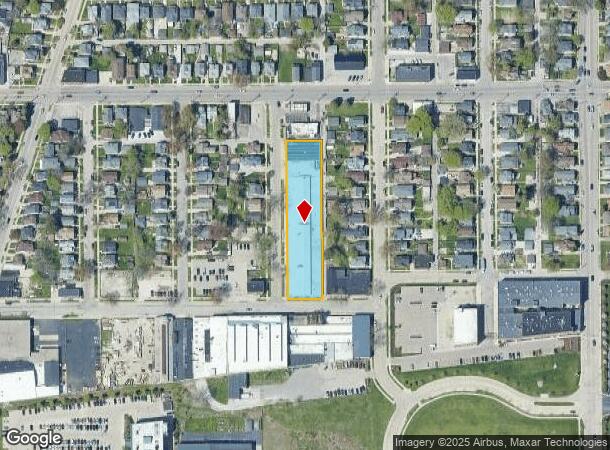
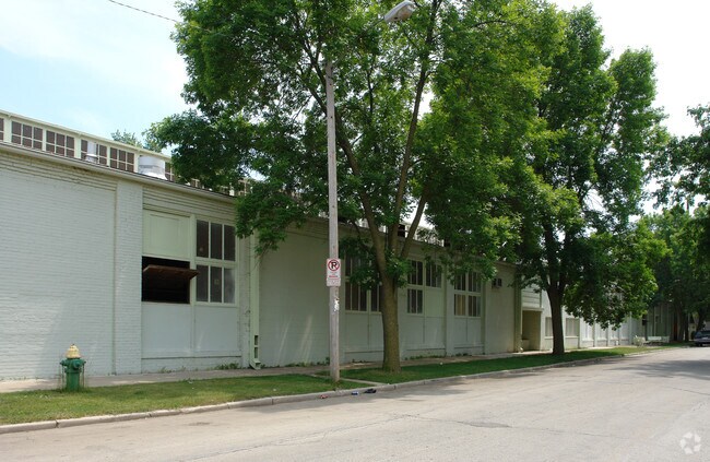
1920 17Th St, Racine, WI 53403

NEARBY LISTINGS FOR SALE OR LEASE
Property Detail
1920 17Th St
Racine-Mount Pleasant, WI
Simonson's
276-000013266000
BLK 1 SIMONSON S ADD LOTS 3 THRU 13 + VAC ALLEY ADJ LOT 3 1.042 AC MOL
Manufacturinglight
Racine
X
Wisconsin
55101C0233E
3
2024
1.04 AC
2024
Racine East
000500
Milwaukee/Madison
DEMOGRAPHICS near 1920 17Th St
1 mile
3 mile
5 mile
2024 Total Population
20,567
79,630
117,802
2029 Population
20,421
79,034
116,889
Pop Growth 2024-2029
(0.71%)
(0.75%)
(0.78%)
Average Age
35
38
39
2024 Total Households
7,936
32,317
48,018
HH Growth 2024-2029
(0.79%)
(0.80%)
(0.81%)
Median Household Inc
$48,860
$51,596
$59,224
Avg Household Size
2.50
2.40
2.30
2024 Avg HH Vehicles
2.00
2.00
2.00
Median Home Value
$127,987
$153,717
$175,403
Median Year Built
1947
1954
1961
Nearby Places
Map Layers
Map Styles
 Street
 Aerial
Transit
 Traffic
 Biking
Places
Listings with unknown addresses are not visible on the map
- Restaurants
- Banks
- Shops
- Fitness
- Groceries
PUBLIC TRANSPORTATION
COMMUTER RAIL
Drive
Walk
Distance
12 min
6.4 mi
Kenosha Station (Union Pacific North Line - Northeast Illinois Regional Commuter Railroad (Metra))
Drive
Walk
Distance
Kenosha Station (Union Pacific North Line - Northeast Illinois Regional Commuter Railroad (Metra))
19 min
9.6 mi
AIRPORT
General Mitchell International
Drive
Walk
Distance
General Mitchell International
36 min
25.4 mi
Nearby Properties
Address
Land Use
TOTAL SIZE
Lot Size
Zoning
Address
Land Use
TOTAL SIZE
Lot Size
Zoning
61,744 SF
42.23 AC
OI
Address
Land Use
TOTAL SIZE
Lot Size
Zoning
14.11 AC
I2
Address
Land Use
TOTAL SIZE
Lot Size
Zoning
180,831 SF
1.49 AC
B4
Address
Land Use
TOTAL SIZE
Lot Size
Zoning
6.77 AC
PUL
Address
Land Use
TOTAL SIZE
Lot Size
Zoning
9,982 SF
0.39 AC
B4
Address
Land Use
TOTAL SIZE
Lot Size
Zoning
33.40 AC
I2
Address
Land Use
TOTAL SIZE
Lot Size
Zoning
98.81 AC
Address
Land Use
TOTAL SIZE
Lot Size
Zoning
Address
Land Use
TOTAL SIZE
Lot Size
Zoning
3.54 AC
B4
Address
Land Use
TOTAL SIZE
Lot Size
Zoning
164,201 SF
17 AC
B2
Address
Land Use
TOTAL SIZE
Lot Size
Zoning
Address
Land Use
TOTAL SIZE
Lot Size
Zoning
Address
Land Use
TOTAL SIZE
Lot Size
Zoning
22.72 AC
Address
Land Use
TOTAL SIZE
Lot Size
Zoning
58,485 SF
19.71 AC
I2
Address
Land Use
TOTAL SIZE
Lot Size
Zoning
Address
Land Use
TOTAL SIZE
Lot Size
Zoning
Address
Land Use
TOTAL SIZE
Lot Size
Zoning
11.56 AC
Address
Land Use
TOTAL SIZE
Lot Size
Zoning
Address
Land Use
TOTAL SIZE
Lot Size
Zoning
23.15 AC
I2
Address
Land Use
TOTAL SIZE
Lot Size
Zoning
102,312 SF
9.92 AC
B2
Address
Land Use
TOTAL SIZE
Lot Size
Zoning
105,550 SF
13.43 AC
Address
Land Use
TOTAL SIZE
Lot Size
Zoning
Address
Land Use
TOTAL SIZE
Lot Size
Zoning
44,439 SF
1.75 AC
B4
Address
Land Use
TOTAL SIZE
Lot Size
Zoning
Address
Land Use
TOTAL SIZE
Lot Size
Zoning
30.06 AC
Address
Land Use
TOTAL SIZE
Lot Size
Zoning
8.08 AC
Address
Land Use
TOTAL SIZE
Lot Size
Zoning
5.04 AC
B-3
Address
Land Use
TOTAL SIZE
Lot Size
Zoning
71,184 SF
1.05 AC
B4
Address
Land Use
TOTAL SIZE
Lot Size
Zoning
78,748 SF
0.88 AC
I2
The World's #1 Commercial Real Estate Marketplace
Connect with us
© 2026 CoStar Group
The information above has been obtained from sources believed reliable. While we do not doubt its accuracy we have not verified it and make no guarantee, warranty or representation about it. It is your responsibility to independently confirm its accuracy and completeness. Any projections, opinions, assumptions, or estimates used are for example only and do not represent the current or future performance of the property. The value of this transaction to you depends on tax and other factors which should be evaluated by your tax, financial, and legal advisors. You and your advisors should conduct a careful, independent investigation of the property to determine to your satisfaction the suitability of the property for your needs.