Property Record
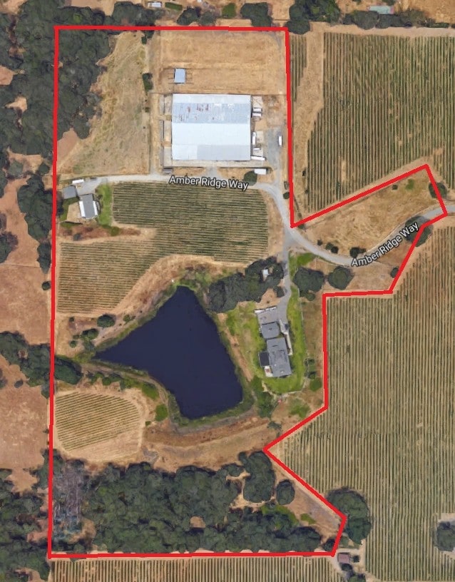
1920 Amber Ridge Way, Windsor, CA 95492

Property Detail
1920 Amber Ridge Way
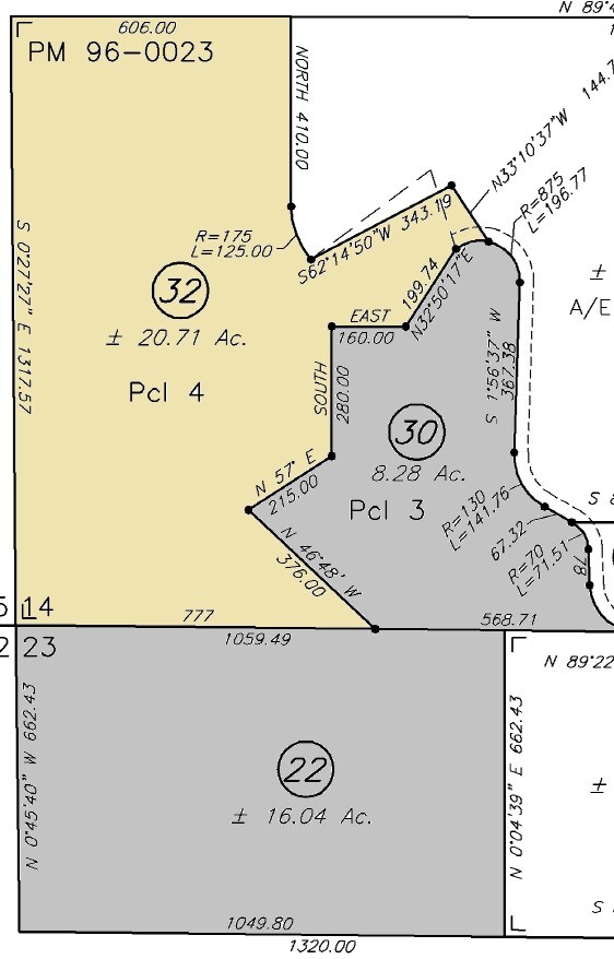
066-200-032
2000 FM PT 066-200-31 &28 99R101618 &19 LLA99-0009
Vineyard
Sonoma
B and X Area of moderate flood hazard, usually the area between the limits of the 100-year and 500-year floods.
California
2025
20.71 AC
2025
Healdsburg/Cloverdale/N.
153810
North Bay/Santa Rosa
1,344 SF
Santa Rosa-Petaluma, CA
NEARBY LISTINGS FOR SALE OR LEASE
DEMOGRAPHICS near 1920 Amber Ridge Way
1 mile
3 mile
5 mile
2025 Total Population
2,563
27,370
39,829
2030 Population
2,553
27,279
39,497
Pop Growth 2025-2030
(0.39%)
(0.33%)
(0.83%)
Average Age
40
43
43
2025 Total Households
778
9,437
14,346
HH Growth 2025-2030
(0.51%)
(0.51%)
(1.00%)
Median Household Inc
$144,700
$126,935
$116,212
Avg Household Size
3.10
2.80
2.70
2025 Avg HH Vehicles
3.00
2.00
2.00
Median Home Value
$810,024
$761,372
$762,249
Median Year Built
2001
1991
1987
Nearby Places
Map Layers
Map Styles
 Street
 Aerial
Layers
 Traffic
 Biking
Places
Listings with unknown addresses are not visible on the map
- Restaurants
- Banks
- Shops
- Fitness
- Groceries
PUBLIC TRANSPORTATION
AIRPORT
Charles M Schulz - Sonoma County
Drive
Walk
Distance
Charles M Schulz - Sonoma County
16 min
4.5 mi
Freight Ports
Port of Richmond
Drive
Walk
Distance
Port of Richmond
81 min
59.3 mi
Nearby Properties
Address
Land Use
TOTAL SIZE
Lot Size
Zoning
Address
Land Use
TOTAL SIZE
Lot Size
Zoning
14.56 AC
Address
Land Use
TOTAL SIZE
Lot Size
Zoning
27,302 SF
63.97 AC
Address
Land Use
TOTAL SIZE
Lot Size
Zoning
249,088 SF
10.75 AC
Address
Land Use
TOTAL SIZE
Lot Size
Zoning
11,906 SF
0.12 AC
DA60
Address
Land Use
TOTAL SIZE
Lot Size
Zoning
154,794 SF
15.09 AC
Address
Land Use
TOTAL SIZE
Lot Size
Zoning
6,770 SF
0.18 AC
LIA60
Address
Land Use
TOTAL SIZE
Lot Size
Zoning
93,886 SF
5.40 AC
MP2
Address
Land Use
TOTAL SIZE
Lot Size
Zoning
100,186 SF
4.31 AC
Address
Land Use
TOTAL SIZE
Lot Size
Zoning
14.29 AC
Address
Land Use
TOTAL SIZE
Lot Size
Zoning
232,262 SF
30.69 AC
Address
Land Use
TOTAL SIZE
Lot Size
Zoning
18.24 AC
Address
Land Use
TOTAL SIZE
Lot Size
Zoning
129,726 SF
12.47 AC
Address
Land Use
TOTAL SIZE
Lot Size
Zoning
23,374 SF
30.07 AC
Address
Land Use
TOTAL SIZE
Lot Size
Zoning
70,358 SF
4.51 AC
M1
Address
Land Use
TOTAL SIZE
Lot Size
Zoning
100,704 SF
84.59 AC
Address
Land Use
TOTAL SIZE
Lot Size
Zoning
282,600 SF
6.89 AC
Address
Land Use
TOTAL SIZE
Lot Size
Zoning
13,953 SF
13.48 AC
LIA40
Address
Land Use
TOTAL SIZE
Lot Size
Zoning
193,263 SF
12.31 AC
Address
Land Use
TOTAL SIZE
Lot Size
Zoning
110,289 SF
11.02 AC
Address
Land Use
TOTAL SIZE
Lot Size
Zoning
69,962 SF
4.49 AC
Address
Land Use
TOTAL SIZE
Lot Size
Zoning
70,511 SF
1.52 AC
Address
Land Use
TOTAL SIZE
Lot Size
Zoning
80,808 SF
6.92 AC
Address
Land Use
TOTAL SIZE
Lot Size
Zoning
98,033 SF
1.39 AC
Address
Land Use
TOTAL SIZE
Lot Size
Zoning
35,648 SF
2.26 AC
M1
Address
Land Use
TOTAL SIZE
Lot Size
Zoning
56,796 SF
7.59 AC
PC
Address
Land Use
TOTAL SIZE
Lot Size
Zoning
0.18 AC
Address
Land Use
TOTAL SIZE
Lot Size
Zoning
63,600 SF
3.72 AC
Address
Land Use
TOTAL SIZE
Lot Size
Zoning
63,600 SF
4.05 AC
Address
Land Use
TOTAL SIZE
Lot Size
Zoning
1,540 SF
0.25 AC
LIA60
Address
Land Use
TOTAL SIZE
Lot Size
Zoning
42,040 SF
45.09 AC
The World's #1 Commercial Real Estate Marketplace
Connect with us
© 2026 CoStar Group
The information above has been obtained from sources believed reliable. While we do not doubt its accuracy we have not verified it and make no guarantee, warranty or representation about it. It is your responsibility to independently confirm its accuracy and completeness. Any projections, opinions, assumptions, or estimates used are for example only and do not represent the current or future performance of the property. The value of this transaction to you depends on tax and other factors which should be evaluated by your tax, financial, and legal advisors. You and your advisors should conduct a careful, independent investigation of the property to determine to your satisfaction the suitability of the property for your needs.