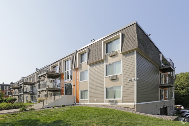
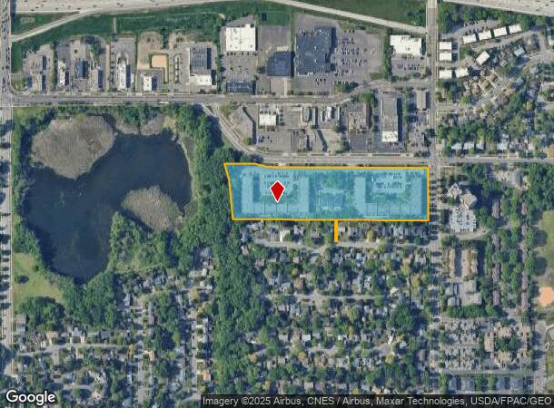
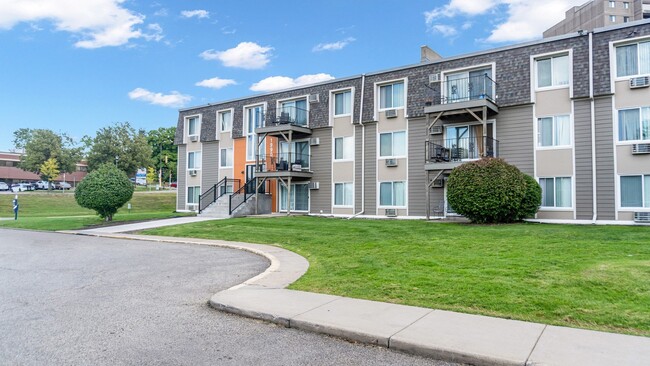
Property Record
1920 Burns Ave, Saint Paul, MN 55119
NEARBY LISTINGS FOR SALE OR LEASE
Property Detail
1920 Burns Ave
Minneapolis-St. Paul-Bloomington, MN-WI
Clapp-Thomssen Battle Cr West
02-28-22-21-0003
CLAPP-THOMSSEN BATTLE CR WEST SUBJ TO RD; LOT 2 BLK 1
Apartment
Ramsey
X
Minnesota
27037C0050E
2
2024
8.99 AC
2025
Battle Creek
034702
Minneapolis/St Paul
185,600 SF
DEMOGRAPHICS near 1920 Burns Ave
1 Mile
3 Mile
5 Mile
2024 Total Population
14,731
101,686
281,977
2029 Population
14,345
99,918
281,802
Pop Growth 2024-2029
(2.62%)
(1.74%)
(0.06%)
Average Age
35
35
37
2024 Total Households
5,279
35,159
106,942
HH Growth 2024-2029
(2.58%)
(1.62%)
+ 0.21%
Median Household Inc
$55,435
$62,046
$67,339
Avg Household Size
2.60
2.70
2.50
2024 Avg HH Vehicles
2.00
2.00
2.00
Median Home Value
$229,007
$225,639
$256,584
Median Year Built
1969
1964
1969
Nearby Places
Map Layers
Map Styles
 Street
 Aerial
- Restaurants
- Banks
- Shops
- Fitness
- Groceries
PUBLIC TRANSPORTATION
COMMUTER RAIL
St. Paul-Minneapolis (Empire Builder - Amtrak)
DRIVE
WALK
Distance
St. Paul-Minneapolis (Empire Builder - Amtrak)
8 min
3.7 mi
AIRPORT
Minneapolis-St Paul International/Wold-Chamberlain
DRIVE
WALK
Distance
Minneapolis-St Paul International/Wold-Chamberlain
21 min
13.0 mi
Freight Ports
Port Milwaukee
DRIVE
WALK
Distance
Port Milwaukee
358 min
325.3 mi
Nearby Properties
Address
Land Use
TOTAL SIZE
Lot Size
Zoning
Address
Land Use
TOTAL SIZE
Lot Size
Zoning
267,948 SF
372.92 AC
Address
Land Use
TOTAL SIZE
Lot Size
Zoning
114,777 SF
22.45 AC
Address
Land Use
TOTAL SIZE
Lot Size
Zoning
270,348 SF
35.96 AC
Address
Land Use
TOTAL SIZE
Lot Size
Zoning
127,888 SF
141.04 AC
Address
Land Use
TOTAL SIZE
Lot Size
Zoning
460,439 SF
25.26 AC
Address
Land Use
TOTAL SIZE
Lot Size
Zoning
29.55 AC
Address
Land Use
TOTAL SIZE
Lot Size
Zoning
32,159 SF
448.26 AC
Address
Land Use
TOTAL SIZE
Lot Size
Zoning
3,080 SF
9.37 AC
Address
Land Use
TOTAL SIZE
Lot Size
Zoning
81,006 SF
12.05 AC
Address
Land Use
TOTAL SIZE
Lot Size
Zoning
147,199 SF
32.47 AC
Address
Land Use
TOTAL SIZE
Lot Size
Zoning
53,851 SF
22.74 AC
Address
Land Use
TOTAL SIZE
Lot Size
Zoning
311,332 SF
36.34 AC
Address
Land Use
TOTAL SIZE
Lot Size
Zoning
181.88 AC
Address
Land Use
TOTAL SIZE
Lot Size
Zoning
41,868 SF
6.69 AC
Address
Land Use
TOTAL SIZE
Lot Size
Zoning
64,563 SF
1.05 AC
Address
Land Use
TOTAL SIZE
Lot Size
Zoning
297,750 SF
11.54 AC
Address
Land Use
TOTAL SIZE
Lot Size
Zoning
262,872 SF
14.22 AC
Address
Land Use
TOTAL SIZE
Lot Size
Zoning
13.43 AC
Address
Land Use
TOTAL SIZE
Lot Size
Zoning
41,201 SF
9.55 AC
Address
Land Use
TOTAL SIZE
Lot Size
Zoning
221,625 SF
3.94 AC
Address
Land Use
TOTAL SIZE
Lot Size
Zoning
49,691 SF
10.94 AC
Address
Land Use
TOTAL SIZE
Lot Size
Zoning
Address
Land Use
TOTAL SIZE
Lot Size
Zoning
163,561 SF
41.09 AC
Address
Land Use
TOTAL SIZE
Lot Size
Zoning
92,091 SF
2.78 AC
Address
Land Use
TOTAL SIZE
Lot Size
Zoning
78,278 SF
4.08 AC
Address
Land Use
TOTAL SIZE
Lot Size
Zoning
188,160 SF
7.53 AC
Address
Land Use
TOTAL SIZE
Lot Size
Zoning
190,062 SF
6.99 AC
Address
Land Use
TOTAL SIZE
Lot Size
Zoning
301,658 SF
21.92 AC
Address
Land Use
TOTAL SIZE
Lot Size
Zoning
192,600 SF
11 AC
The World's #1 Commercial Real Estate Marketplace
Connect with us
© 2025 CoStar Group
The information above has been obtained from sources believed reliable. While we do not doubt its accuracy we have not verified it and make no guarantee, warranty or representation about it. It is your responsibility to independently confirm its accuracy and completeness. Any projections, opinions, assumptions, or estimates used are for example only and do not represent the current or future performance of the property. The value of this transaction to you depends on tax and other factors which should be evaluated by your tax, financial, and legal advisors. You and your advisors should conduct a careful, independent investigation of the property to determine to your satisfaction the suitability of the property for your needs.