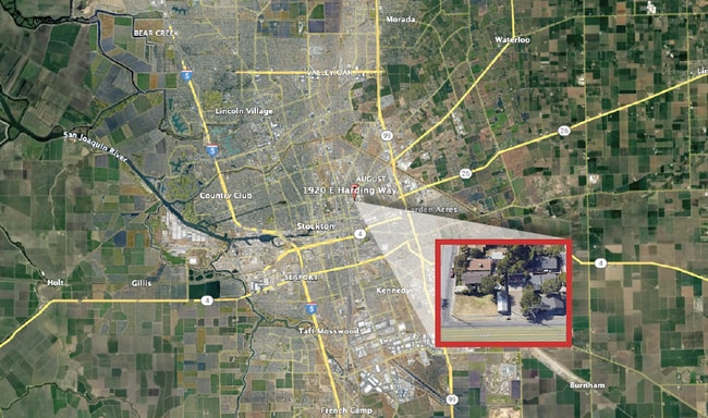
Property Record
1920 E Harding Way, Stockton, CA 95205
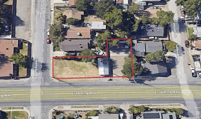

This Property Is For Sale
Property Detail
1920 E Harding Way
Stockton-Lodi, CA
B/O ALWNG 1400 HOX 12-8-76
117-235-11
SAN JOAQUIN
Commercialacreage
California
2025
0.20 AC
2025
Stockton
001600
Stockton/Modesto
NEARBY LISTINGS FOR SALE OR LEASE
DEMOGRAPHICS near 1920 E Harding Way
1 mile
3 mile
5 mile
2025 Total Population
17,635
153,046
308,385
2030 Population
18,331
159,332
320,842
Pop Growth 2025-2030
+ 3.95%
+ 4.11%
+ 4.04%
Average Age
34
36
36
2025 Total Households
4,991
46,810
94,941
HH Growth 2025-2030
+ 4.03%
+ 4.42%
+ 4.23%
Median Household Inc
$58,718
$61,370
$69,569
Avg Household Size
3.40
3.10
3.10
2025 Avg HH Vehicles
2.00
2.00
2.00
Median Home Value
$300,258
$366,314
$396,725
Median Year Built
1955
1963
1973
Nearby Places
Map Layers
Map Styles
 Street
 Aerial
Transit
 Traffic
 Biking
Places
Listings with unknown addresses are not visible on the map
- Restaurants
- Banks
- Shops
- Fitness
- Groceries
PUBLIC TRANSPORTATION
COMMUTER RAIL
Drive
Walk
Distance
4 min
1.6 mi
Drive
Walk
Distance
6 min
2.6 mi
AIRPORT
Stockton Metro
Drive
Walk
Distance
Stockton Metro
13 min
6.3 mi
Freight Ports
Port of Stockton
Drive
Walk
Distance
Port of Stockton
10 min
4.1 mi
Nearby Properties
Address
Land Use
TOTAL SIZE
Lot Size
Zoning
Address
Land Use
TOTAL SIZE
Lot Size
Zoning
530,700 SF
8.35 AC
Address
Land Use
TOTAL SIZE
Lot Size
Zoning
30,080 SF
82.44 AC
Address
Land Use
TOTAL SIZE
Lot Size
Zoning
152,000 SF
1.31 AC
Address
Land Use
TOTAL SIZE
Lot Size
Zoning
4.78 AC
Address
Land Use
TOTAL SIZE
Lot Size
Zoning
10,208 SF
47.57 AC
Address
Land Use
TOTAL SIZE
Lot Size
Zoning
9,750 SF
136.94 AC
AU20
Address
Land Use
TOTAL SIZE
Lot Size
Zoning
502,000 SF
19.76 AC
Address
Land Use
TOTAL SIZE
Lot Size
Zoning
22.89 AC
Address
Land Use
TOTAL SIZE
Lot Size
Zoning
652,548 SF
35.24 AC
IL
Address
Land Use
TOTAL SIZE
Lot Size
Zoning
121,574 SF
5.49 AC
RHD
Address
Land Use
TOTAL SIZE
Lot Size
Zoning
47.61 AC
Address
Land Use
TOTAL SIZE
Lot Size
Zoning
82,512 SF
4.14 AC
Address
Land Use
TOTAL SIZE
Lot Size
Zoning
219,572 SF
16.53 AC
IL
Address
Land Use
TOTAL SIZE
Lot Size
Zoning
14,212 SF
26.11 AC
Address
Land Use
TOTAL SIZE
Lot Size
Zoning
23.30 AC
Address
Land Use
TOTAL SIZE
Lot Size
Zoning
15,203 SF
3.65 AC
Address
Land Use
TOTAL SIZE
Lot Size
Zoning
8,000 SF
0.67 AC
Address
Land Use
TOTAL SIZE
Lot Size
Zoning
62,588 SF
43.56 AC
IW
Address
Land Use
TOTAL SIZE
Lot Size
Zoning
0.79 AC
Address
Land Use
TOTAL SIZE
Lot Size
Zoning
37,846 SF
2.94 AC
Address
Land Use
TOTAL SIZE
Lot Size
Zoning
2.42 AC
Address
Land Use
TOTAL SIZE
Lot Size
Zoning
2,876 SF
10.54 AC
Address
Land Use
TOTAL SIZE
Lot Size
Zoning
67,195 SF
5.30 AC
Address
Land Use
TOTAL SIZE
Lot Size
Zoning
119,341 SF
7.98 AC
Address
Land Use
TOTAL SIZE
Lot Size
Zoning
95,838 SF
10.10 AC
Address
Land Use
TOTAL SIZE
Lot Size
Zoning
129,750 SF
8.63 AC
Address
Land Use
TOTAL SIZE
Lot Size
Zoning
261,860 SF
7.48 AC
IW
Address
Land Use
TOTAL SIZE
Lot Size
Zoning
84,895 SF
2.21 AC
Address
Land Use
TOTAL SIZE
Lot Size
Zoning
76,500 SF
7.03 AC
The World's #1 Commercial Real Estate Marketplace
Connect with us
© 2026 CoStar Group
The information above has been obtained from sources believed reliable. While we do not doubt its accuracy we have not verified it and make no guarantee, warranty or representation about it. It is your responsibility to independently confirm its accuracy and completeness. Any projections, opinions, assumptions, or estimates used are for example only and do not represent the current or future performance of the property. The value of this transaction to you depends on tax and other factors which should be evaluated by your tax, financial, and legal advisors. You and your advisors should conduct a careful, independent investigation of the property to determine to your satisfaction the suitability of the property for your needs.