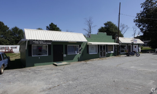
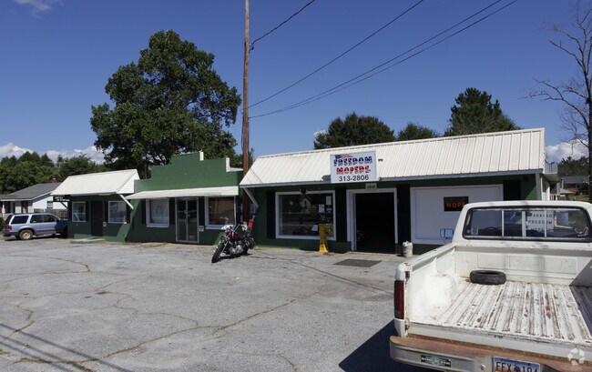
Property Record
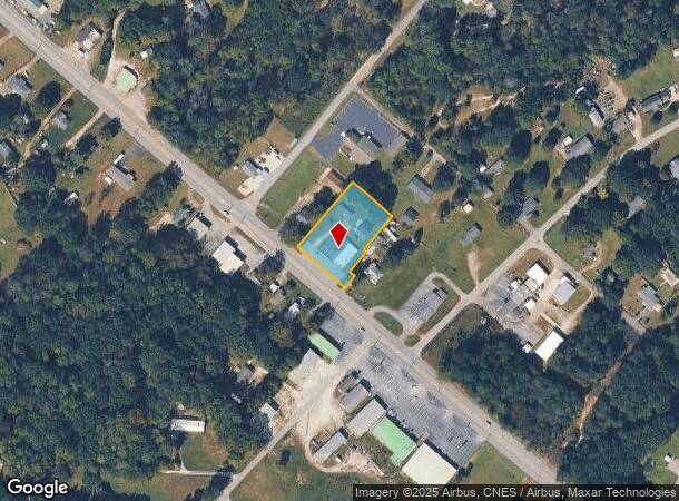
1920 Gentry Memorial Hwy, Easley, SC 29640
NEARBY LISTINGS FOR SALE OR LEASE
Property Detail
1920 Gentry Memorial Hwy
4190-16-93-9474
NE/SIDE HWY 8 PICKENS HWY PLAT 605/313
Storebuilding
Pickens
X
South Carolina
45007C0025E
0.87 AC
2024
Pickens County
2024
Greenville/Spartanburg
010700
Greenville-Anderson-Mauldin, SC
4,658 SF
DEMOGRAPHICS near 1920 Gentry Memorial Hwy
1 Mile
3 Mile
5 Mile
2024 Total Population
1,658
11,704
37,374
2029 Population
1,723
12,232
39,203
Pop Growth 2024-2029
+ 3.92%
+ 4.51%
+ 4.89%
Average Age
43
41
41
2024 Total Households
682
4,482
15,001
HH Growth 2024-2029
+ 4.11%
+ 4.64%
+ 5.02%
Median Household Inc
$65,755
$44,172
$44,173
Avg Household Size
2.40
2.50
2.40
2024 Avg HH Vehicles
2.00
2.00
2.00
Median Home Value
$208,823
$150,048
$153,934
Median Year Built
1990
1984
1982
Nearby Places
Map Layers
Map Styles
 Street
 Aerial
- Restaurants
- Banks
- Shops
- Fitness
- Groceries
PUBLIC TRANSPORTATION
AIRPORT
Greenville Spartanburg International
DRIVE
WALK
Distance
Greenville Spartanburg International
50 min
32.3 mi
Freight Ports
North Charleston Terminal
DRIVE
WALK
Distance
North Charleston Terminal
253 min
218.7 mi
Nearby Properties
Address
Land Use
TOTAL SIZE
Lot Size
Zoning
Address
Land Use
TOTAL SIZE
Lot Size
Zoning
56,599 SF
8.02 AC
RM16
Address
Land Use
TOTAL SIZE
Lot Size
Zoning
13,376 SF
12.36 AC
Address
Land Use
TOTAL SIZE
Lot Size
Zoning
29,595 SF
2.94 AC
R12
Address
Land Use
TOTAL SIZE
Lot Size
Zoning
5,356 SF
17.33 AC
Address
Land Use
TOTAL SIZE
Lot Size
Zoning
30,000 SF
3.30 AC
Address
Land Use
TOTAL SIZE
Lot Size
Zoning
27,700 SF
12.91 AC
Address
Land Use
TOTAL SIZE
Lot Size
Zoning
39,480 SF
3.26 AC
Address
Land Use
TOTAL SIZE
Lot Size
Zoning
12,466 SF
2.32 AC
R12
Address
Land Use
TOTAL SIZE
Lot Size
Zoning
4,829 SF
2 AC
Address
Land Use
TOTAL SIZE
Lot Size
Zoning
180.03 AC
Address
Land Use
TOTAL SIZE
Lot Size
Zoning
5,645 SF
0.67 AC
Address
Land Use
TOTAL SIZE
Lot Size
Zoning
6,070 SF
1.71 AC
CBD
Address
Land Use
TOTAL SIZE
Lot Size
Zoning
2,679 SF
0.58 AC
Address
Land Use
TOTAL SIZE
Lot Size
Zoning
19,852 SF
47.45 AC
GBD
Address
Land Use
TOTAL SIZE
Lot Size
Zoning
5,508 SF
4.78 AC
Address
Land Use
TOTAL SIZE
Lot Size
Zoning
5,468 SF
0.75 AC
CBD
Address
Land Use
TOTAL SIZE
Lot Size
Zoning
114.97 AC
Address
Land Use
TOTAL SIZE
Lot Size
Zoning
91,940 SF
15.07 AC
GBD
Address
Land Use
TOTAL SIZE
Lot Size
Zoning
20,652 SF
3.89 AC
Address
Land Use
TOTAL SIZE
Lot Size
Zoning
2,434 SF
6.19 AC
Address
Land Use
TOTAL SIZE
Lot Size
Zoning
1,296 SF
11.05 AC
Address
Land Use
TOTAL SIZE
Lot Size
Zoning
5,400 SF
2.20 AC
GBD
Address
Land Use
TOTAL SIZE
Lot Size
Zoning
2,997 SF
1.50 AC
GBD
Address
Land Use
TOTAL SIZE
Lot Size
Zoning
32,181 SF
2.90 AC
GBD
Address
Land Use
TOTAL SIZE
Lot Size
Zoning
1,716 SF
1.01 AC
GBD
Address
Land Use
TOTAL SIZE
Lot Size
Zoning
1,514 SF
0.34 AC
Address
Land Use
TOTAL SIZE
Lot Size
Zoning
12.41 AC
Address
Land Use
TOTAL SIZE
Lot Size
Zoning
30.89 AC
Address
Land Use
TOTAL SIZE
Lot Size
Zoning
14,461 SF
2.48 AC
GBD
Address
Land Use
TOTAL SIZE
Lot Size
Zoning
23.39 AC
GBD
The World's #1 Commercial Real Estate Marketplace
Connect with us
© 2025 CoStar Group
The information above has been obtained from sources believed reliable. While we do not doubt its accuracy we have not verified it and make no guarantee, warranty or representation about it. It is your responsibility to independently confirm its accuracy and completeness. Any projections, opinions, assumptions, or estimates used are for example only and do not represent the current or future performance of the property. The value of this transaction to you depends on tax and other factors which should be evaluated by your tax, financial, and legal advisors. You and your advisors should conduct a careful, independent investigation of the property to determine to your satisfaction the suitability of the property for your needs.