Property Record
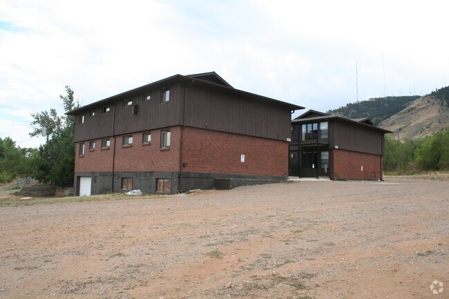
1920 Jones Rd, Golden, CO 80401


NEARBY LISTINGS FOR SALE OR LEASE
Property Detail
1920 Jones Rd
30-334-00-005
Acreage
Commercialnec
SECTION 33 TOWNSHIP 03 RANGE 70 QTR SE SIZE: 60243 VALUE: 1.383 KEY=044
X
Jefferson
08059C0276F
Colorado
0
1.38 AC
2024
Downtown Golden
010001
Denver
6,890 SF
Denver-Aurora-Lakewood, CO
DEMOGRAPHICS near 1920 Jones Rd
1 Mile
3 Mile
5 Mile
2024 Total Population
7,777
27,062
72,351
2029 Population
7,840
26,992
71,939
Pop Growth 2024-2029
+ 0.81%
(0.26%)
(0.57%)
Average Age
35
39
41
2024 Total Households
2,702
10,661
29,689
HH Growth 2024-2029
+ 1.30%
(0.24%)
(0.55%)
Median Household Inc
$79,964
$91,978
$101,384
Avg Household Size
2.00
2.20
2.30
2024 Avg HH Vehicles
2.00
2.00
2.00
Median Home Value
$725,352
$666,714
$697,695
Median Year Built
1975
1983
1981
Nearby Places
Map Layers
Map Styles
 Street
 Aerial
- Restaurants
- Banks
- Shops
- Fitness
- Groceries
PUBLIC TRANSPORTATION
COMMUTER RAIL
Wheat Ridge - Ward Station Track 1 (Union Station to Wheat Ridge Ward Station - Regional Transportation District)
DRIVE
WALK
Distance
Wheat Ridge - Ward Station Track 1 (Union Station to Wheat Ridge Ward Station - Regional Transportation District)
14 min
8.7 mi
Arvada Ridge Station Track 1 (Union Station to Wheat Ridge Ward Station - Regional Transportation District)
DRIVE
WALK
Distance
Arvada Ridge Station Track 1 (Union Station to Wheat Ridge Ward Station - Regional Transportation District)
14 min
9.7 mi
Freight Ports
Tulsa Port Of Catoosa
DRIVE
WALK
Distance
Tulsa Port Of Catoosa
744 min
722.8 mi
Nearby Properties
Address
Land Use
TOTAL SIZE
Lot Size
Zoning
Address
Land Use
TOTAL SIZE
Lot Size
Zoning
Address
Land Use
TOTAL SIZE
Lot Size
Zoning
367,452 SF
38.94 AC
Address
Land Use
TOTAL SIZE
Lot Size
Zoning
3,357,529 SF
32.87 AC
Address
Land Use
TOTAL SIZE
Lot Size
Zoning
420,482 SF
66.03 AC
Address
Land Use
TOTAL SIZE
Lot Size
Zoning
69,819 SF
1,402.21 AC
R1
Address
Land Use
TOTAL SIZE
Lot Size
Zoning
352,259 SF
17.94 AC
Address
Land Use
TOTAL SIZE
Lot Size
Zoning
589,966 SF
23.48 AC
Address
Land Use
TOTAL SIZE
Lot Size
Zoning
Address
Land Use
TOTAL SIZE
Lot Size
Zoning
156,531 SF
8.20 AC
Address
Land Use
TOTAL SIZE
Lot Size
Zoning
188,554 SF
33.28 AC
Address
Land Use
TOTAL SIZE
Lot Size
Zoning
322,105 SF
136.23 AC
Address
Land Use
TOTAL SIZE
Lot Size
Zoning
198,147 SF
2.55 AC
Address
Land Use
TOTAL SIZE
Lot Size
Zoning
1,115,227 SF
84.74 AC
I2
Address
Land Use
TOTAL SIZE
Lot Size
Zoning
260,325 SF
13.70 AC
Address
Land Use
TOTAL SIZE
Lot Size
Zoning
350,722 SF
73.85 AC
R1
Address
Land Use
TOTAL SIZE
Lot Size
Zoning
55,030 SF
4.94 AC
Address
Land Use
TOTAL SIZE
Lot Size
Zoning
454.79 AC
A2
Address
Land Use
TOTAL SIZE
Lot Size
Zoning
391,506 SF
10.02 AC
Address
Land Use
TOTAL SIZE
Lot Size
Zoning
68,773 SF
9.90 AC
Address
Land Use
TOTAL SIZE
Lot Size
Zoning
240,059 SF
58.36 AC
Address
Land Use
TOTAL SIZE
Lot Size
Zoning
120,967 SF
9.54 AC
Address
Land Use
TOTAL SIZE
Lot Size
Zoning
129,753 SF
11.40 AC
Address
Land Use
TOTAL SIZE
Lot Size
Zoning
109,428 SF
12.76 AC
Address
Land Use
TOTAL SIZE
Lot Size
Zoning
67,473 SF
6.90 AC
Address
Land Use
TOTAL SIZE
Lot Size
Zoning
57,434 SF
5.19 AC
Address
Land Use
TOTAL SIZE
Lot Size
Zoning
206,151 SF
7.67 AC
Address
Land Use
TOTAL SIZE
Lot Size
Zoning
190,874 SF
17.36 AC
Address
Land Use
TOTAL SIZE
Lot Size
Zoning
90,663 SF
56.05 AC
Address
Land Use
TOTAL SIZE
Lot Size
Zoning
82,432 SF
1.62 AC
Address
Land Use
TOTAL SIZE
Lot Size
Zoning
173,500 SF
5.16 AC
The World's #1 Commercial Real Estate Marketplace
Connect with us
© 2025 CoStar Group
The information above has been obtained from sources believed reliable. While we do not doubt its accuracy we have not verified it and make no guarantee, warranty or representation about it. It is your responsibility to independently confirm its accuracy and completeness. Any projections, opinions, assumptions, or estimates used are for example only and do not represent the current or future performance of the property. The value of this transaction to you depends on tax and other factors which should be evaluated by your tax, financial, and legal advisors. You and your advisors should conduct a careful, independent investigation of the property to determine to your satisfaction the suitability of the property for your needs.