Property Record
1920 N Drexel Blvd, Oklahoma City, OK 73107


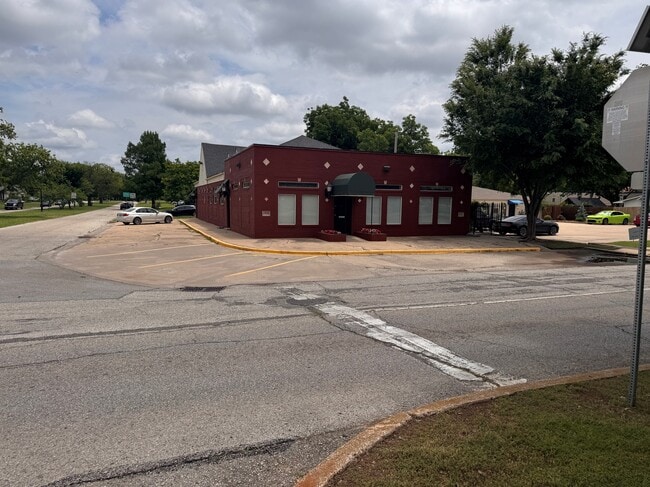
This Property Is For Sale
Current Lease Availabilities
NEARBY LISTINGS FOR SALE OR LEASE
Property Detail
1920 N Drexel Blvd
Oklahoma City, OK
Milam Place Addition
065187540
MILAM PLACE ADDITION 014 000 W107.5FT OF LOTS 18 & 19
Commercialnec
Oklahoma
X
Oklahoma
40109C0280H
18,19
2023
0.12 AC
2024
West/Central
102100
Oklahoma City
3,603 SF
DEMOGRAPHICS near 1920 N Drexel Blvd
1 Mile
3 Mile
5 Mile
2024 Total Population
14,236
97,889
236,624
2029 Population
14,522
100,793
244,351
Pop Growth 2024-2029
+ 2.01%
+ 2.97%
+ 3.27%
Average Age
36
36
37
2024 Total Households
6,005
42,274
98,747
HH Growth 2024-2029
+ 2.05%
+ 3.07%
+ 3.37%
Median Household Inc
$53,466
$48,376
$47,672
Avg Household Size
2.30
2.20
2.30
2024 Avg HH Vehicles
2.00
2.00
2.00
Median Home Value
$143,070
$157,737
$152,606
Median Year Built
1946
1956
1961
Nearby Places
Map Layers
Map Styles
 Street
 Aerial
- Restaurants
- Banks
- Shops
- Fitness
- Groceries
PUBLIC TRANSPORTATION
COMMUTER RAIL
Oklahoma City (Heartland Flyer - Amtrak)
DRIVE
WALK
Distance
Oklahoma City (Heartland Flyer - Amtrak)
9 min
4.7 mi
AIRPORT
Will Rogers World
DRIVE
WALK
Distance
Will Rogers World
19 min
9.2 mi
Freight Ports
Tulsa Port Of Catoosa
DRIVE
WALK
Distance
Tulsa Port Of Catoosa
136 min
124.7 mi
Nearby Properties
Address
Land Use
TOTAL SIZE
Lot Size
Zoning
Address
Land Use
TOTAL SIZE
Lot Size
Zoning
819,976 SF
21.87 AC
C-3
Address
Land Use
TOTAL SIZE
Lot Size
Zoning
40,914 SF
0.50 AC
DTD-1
Address
Land Use
TOTAL SIZE
Lot Size
Zoning
417,965 SF
3.48 AC
DTD-1
Address
Land Use
TOTAL SIZE
Lot Size
Zoning
413,783 SF
6.25 AC
DBD
Address
Land Use
TOTAL SIZE
Lot Size
Zoning
194,762 SF
3 AC
DTD-1
Address
Land Use
TOTAL SIZE
Lot Size
Zoning
467,216 SF
66.90 AC
C-3
Address
Land Use
TOTAL SIZE
Lot Size
Zoning
44,519 SF
3.39 AC
SPUD
Address
Land Use
TOTAL SIZE
Lot Size
Zoning
90,059 SF
14.99 AC
O-2
Address
Land Use
TOTAL SIZE
Lot Size
Zoning
2.59 AC
DBD
Address
Land Use
TOTAL SIZE
Lot Size
Zoning
430,092 SF
17.35 AC
R-4
Address
Land Use
TOTAL SIZE
Lot Size
Zoning
485,764 SF
6.05 AC
C-3
Address
Land Use
TOTAL SIZE
Lot Size
Zoning
452,123 SF
5.64 AC
O-2
Address
Land Use
TOTAL SIZE
Lot Size
Zoning
246,774 SF
55.60 AC
PUD
Address
Land Use
TOTAL SIZE
Lot Size
Zoning
28,099 SF
1.21 AC
O-2
Address
Land Use
TOTAL SIZE
Lot Size
Zoning
26,340 SF
2.38 AC
NC
Address
Land Use
TOTAL SIZE
Lot Size
Zoning
181,946 SF
4.42 AC
C-4
Address
Land Use
TOTAL SIZE
Lot Size
Zoning
371,946 SF
31.38 AC
I-2
Address
Land Use
TOTAL SIZE
Lot Size
Zoning
178,297 SF
4.25 AC
Address
Land Use
TOTAL SIZE
Lot Size
Zoning
29,274 SF
0.93 AC
C-3
Address
Land Use
TOTAL SIZE
Lot Size
Zoning
239,466 SF
1.73 AC
DTD-2
Address
Land Use
TOTAL SIZE
Lot Size
Zoning
2,950 SF
1.51 AC
DTD-2
Address
Land Use
TOTAL SIZE
Lot Size
Zoning
681,708 SF
20.54 AC
C-3
Address
Land Use
TOTAL SIZE
Lot Size
Zoning
697,098 SF
88.91 AC
C-3
Address
Land Use
TOTAL SIZE
Lot Size
Zoning
158,150 SF
15.18 AC
I-2
Address
Land Use
TOTAL SIZE
Lot Size
Zoning
141,204 SF
6.10 AC
I-2
Address
Land Use
TOTAL SIZE
Lot Size
Zoning
69,370 SF
O-2
Address
Land Use
TOTAL SIZE
Lot Size
Zoning
246,884 SF
11.64 AC
I-2
Address
Land Use
TOTAL SIZE
Lot Size
Zoning
327,372 SF
14.79 AC
R-4
Address
Land Use
TOTAL SIZE
Lot Size
Zoning
370,066 SF
6.83 AC
O-2
Address
Land Use
TOTAL SIZE
Lot Size
Zoning
14,720 SF
0.81 AC
C-3
The World's #1 Commercial Real Estate Marketplace
Connect with us
© 2026 CoStar Group
The information above has been obtained from sources believed reliable. While we do not doubt its accuracy we have not verified it and make no guarantee, warranty or representation about it. It is your responsibility to independently confirm its accuracy and completeness. Any projections, opinions, assumptions, or estimates used are for example only and do not represent the current or future performance of the property. The value of this transaction to you depends on tax and other factors which should be evaluated by your tax, financial, and legal advisors. You and your advisors should conduct a careful, independent investigation of the property to determine to your satisfaction the suitability of the property for your needs.