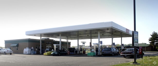
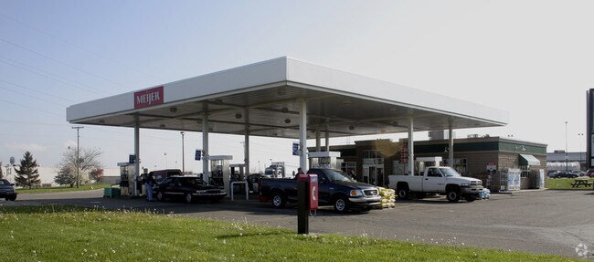
Property Record
1920 Pipestone Rd, Benton Harbor, MI 49022

Property Detail
1920 Pipestone Rd
11-03-0032-0034-01-0
SPLIT ON 10/14/2020 FROM 03-0032-0009-75-7; FROM N1/4 PST SEC 32 T4S R18W RUN S89DEG21'45''E 1877.8' TH ON A 733.89' RAD CUR RT A CHORD DIS OF S16DEG56'05''E 198.92' TH S09DEG08'45''E 894.92' TH N89DEG21'45''W 345.5' TO POB TH S00DEG38'15W 150' TH S8
Conveniencestore
Berrien
B and X Area of moderate flood hazard, usually the area between the limits of the 100-year and 500-year floods.
Michigan
2024
25.05 AC
2025
Michigan Southwest Area
002100
Other Market Areas
218,334 SF
Niles, MI
NEARBY LISTINGS FOR SALE OR LEASE
DEMOGRAPHICS near 1920 Pipestone Rd
1 mile
3 mile
5 mile
2025 Total Population
1,412
24,052
46,665
2030 Population
1,370
23,689
45,802
Pop Growth 2025-2030
(2.97%)
(1.51%)
(1.85%)
Average Age
43
39
41
2025 Total Households
665
9,500
19,273
HH Growth 2025-2030
(3.46%)
(1.84%)
(2.13%)
Median Household Inc
$32,736
$39,564
$60,162
Avg Household Size
2.10
2.40
2.30
2025 Avg HH Vehicles
1.00
1.00
2.00
Median Home Value
$95,485
$163,498
$247,877
Median Year Built
1957
1961
1963
Nearby Places
Map Layers
Map Styles
 Street
 Aerial
Layers
 Traffic
 Biking
Places
Listings with unknown addresses are not visible on the map
- Restaurants
- Banks
- Shops
- Fitness
- Groceries
PUBLIC TRANSPORTATION
COMMUTER RAIL
Drive
Walk
Distance
12 min
4.9 mi
AIRPORT
South Bend International
Drive
Walk
Distance
South Bend International
49 min
32.4 mi
Nearby Properties
Address
Land Use
TOTAL SIZE
Lot Size
Zoning
Address
Land Use
TOTAL SIZE
Lot Size
Zoning
200,321 SF
15.47 AC
D1 COMM
Address
Land Use
TOTAL SIZE
Lot Size
Zoning
69,180 SF
3.58 AC
D1 COMM
Address
Land Use
TOTAL SIZE
Lot Size
Zoning
73,505 SF
4.02 AC
D1 COMM
Address
Land Use
TOTAL SIZE
Lot Size
Zoning
66,680 SF
3.42 AC
Address
Land Use
TOTAL SIZE
Lot Size
Zoning
296,788 SF
34 AC
D1 COMM
Address
Land Use
TOTAL SIZE
Lot Size
Zoning
258,549 SF
17.20 AC
C MULTI
Address
Land Use
TOTAL SIZE
Lot Size
Zoning
62,800 SF
3.06 AC
Address
Land Use
TOTAL SIZE
Lot Size
Zoning
171,165 SF
15.15 AC
D1 COMM
Address
Land Use
TOTAL SIZE
Lot Size
Zoning
61,732 SF
3.51 AC
D1 COMM
Address
Land Use
TOTAL SIZE
Lot Size
Zoning
42,610 SF
5.30 AC
C4 HEAVY
Address
Land Use
TOTAL SIZE
Lot Size
Zoning
112,503 SF
4.30 AC
C MULTI FA
Address
Land Use
TOTAL SIZE
Lot Size
Zoning
75,050 SF
5.33 AC
NONE
Address
Land Use
TOTAL SIZE
Lot Size
Zoning
126,127 SF
11.84 AC
D1 COMM
Address
Land Use
TOTAL SIZE
Lot Size
Zoning
204,000 SF
34.08 AC
F HEAVY
Address
Land Use
TOTAL SIZE
Lot Size
Zoning
90,000 SF
7.62 AC
W
Address
Land Use
TOTAL SIZE
Lot Size
Zoning
391,928 SF
40.84 AC
F HEAVY
Address
Land Use
TOTAL SIZE
Lot Size
Zoning
84,732 SF
4.19 AC
C MULTI FA
Address
Land Use
TOTAL SIZE
Lot Size
Zoning
77,703 SF
28.05 AC
F HEAVY
Address
Land Use
TOTAL SIZE
Lot Size
Zoning
88,572 SF
15.70 AC
D1 COMM
Address
Land Use
TOTAL SIZE
Lot Size
Zoning
254,984 SF
25.04 AC
R-A RE
Address
Land Use
TOTAL SIZE
Lot Size
Zoning
49,527 SF
4.47 AC
PUD
Address
Land Use
TOTAL SIZE
Lot Size
Zoning
70,617 SF
12 AC
E RESTRICT
Address
Land Use
TOTAL SIZE
Lot Size
Zoning
103,591 SF
8.77 AC
D1 COMM
Address
Land Use
TOTAL SIZE
Lot Size
Zoning
69,484 SF
8.08 AC
C MULTI
Address
Land Use
TOTAL SIZE
Lot Size
Zoning
18.05 AC
D1 COMM
Address
Land Use
TOTAL SIZE
Lot Size
Zoning
151,462 SF
9.96 AC
DISTRICT F
Address
Land Use
TOTAL SIZE
Lot Size
Zoning
60,188 SF
3.59 AC
D1 COMM
Address
Land Use
TOTAL SIZE
Lot Size
Zoning
55,753 SF
6 AC
DISTRICT D
Address
Land Use
TOTAL SIZE
Lot Size
Zoning
172,489 SF
12.66 AC
E RESTRICT
The World's #1 Commercial Real Estate Marketplace
Connect with us
© 2026 CoStar Group
The information above has been obtained from sources believed reliable. While we do not doubt its accuracy we have not verified it and make no guarantee, warranty or representation about it. It is your responsibility to independently confirm its accuracy and completeness. Any projections, opinions, assumptions, or estimates used are for example only and do not represent the current or future performance of the property. The value of this transaction to you depends on tax and other factors which should be evaluated by your tax, financial, and legal advisors. You and your advisors should conduct a careful, independent investigation of the property to determine to your satisfaction the suitability of the property for your needs.