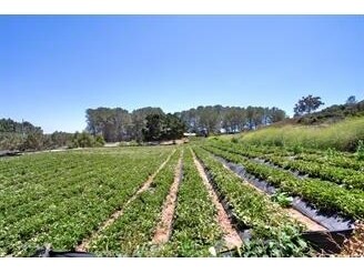
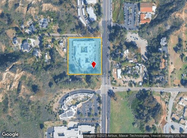
Property Record
1920 S El Camino Real, Encinitas, CA 92024
NEARBY LISTINGS FOR SALE OR LEASE
Property Detail
1920 S El Camino Real
262-160-31
San Diego Tech Center
Hospitalprivate
SEC 23-13-4W SEQ DOC19-0320386 IN SEQ OF SEQ OF
X
San Diego
06073C1044H
California
2024
3.24 AC
2025
North Beach Cities
017406
San Diego
90,028 SF
San Diego-Carlsbad, CA
DEMOGRAPHICS near 1920 S El Camino Real
1 Mile
3 Mile
5 Mile
2024 Total Population
5,702
63,685
123,184
2029 Population
5,574
63,460
122,382
Pop Growth 2024-2029
(2.24%)
(0.35%)
(0.65%)
Average Age
45
44
44
2024 Total Households
2,136
25,398
48,508
HH Growth 2024-2029
(2.57%)
(0.33%)
(0.68%)
Median Household Inc
$166,548
$136,208
$148,413
Avg Household Size
2.50
2.40
2.50
2024 Avg HH Vehicles
2.00
2.00
2.00
Median Home Value
$1,113,489
$1,096,172
$1,100,965
Median Year Built
1977
1977
1980
Nearby Places
Map Layers
Map Styles
 Street
 Aerial
- Restaurants
- Banks
- Shops
- Fitness
- Groceries
PUBLIC TRANSPORTATION
COMMUTER RAIL
Solana Beach (Coaster - San Diego North County Transit District (Coaster/Sprinter/Breeze))
DRIVE
WALK
Distance
Solana Beach (Coaster - San Diego North County Transit District (Coaster/Sprinter/Breeze))
7 min
3.6 mi
Encinitas (Coaster - San Diego North County Transit District (Coaster/Sprinter/Breeze))
DRIVE
WALK
Distance
Encinitas (Coaster - San Diego North County Transit District (Coaster/Sprinter/Breeze))
8 min
4.1 mi
AIRPORT
San Diego International
DRIVE
WALK
Distance
San Diego International
30 min
22.5 mi
Freight Ports
Port of San Diego
DRIVE
WALK
Distance
Port of San Diego
34 min
26.8 mi
SALE & LEASE HISTORY
LISTING DATE
SALE/LEASE

Sep 25, 2016
For Lease
Nearby Properties
Address
Land Use
TOTAL SIZE
Lot Size
Zoning
Address
Land Use
TOTAL SIZE
Lot Size
Zoning
13.11 AC
P/SP
Address
Land Use
TOTAL SIZE
Lot Size
Zoning
70,334 SF
9.92 AC
CC-1-3
Address
Land Use
TOTAL SIZE
Lot Size
Zoning
17.80 AC
GC
Address
Land Use
TOTAL SIZE
Lot Size
Zoning
71,369 SF
4.99 AC
CC-1-3
Address
Land Use
TOTAL SIZE
Lot Size
Zoning
12.44 AC
P/SP
Address
Land Use
TOTAL SIZE
Lot Size
Zoning
4.46 AC
RR1
Address
Land Use
TOTAL SIZE
Lot Size
Zoning
4.77 AC
ER-MU1
Address
Land Use
TOTAL SIZE
Lot Size
Zoning
91,869 SF
1.72 AC
C
Address
Land Use
TOTAL SIZE
Lot Size
Zoning
46,415 SF
5.96 AC
S88
Address
Land Use
TOTAL SIZE
Lot Size
Zoning
8.23 AC
C
Address
Land Use
TOTAL SIZE
Lot Size
Zoning
11 AC
GC
Address
Land Use
TOTAL SIZE
Lot Size
Zoning
16.89 AC
MHRd
Address
Land Use
TOTAL SIZE
Lot Size
Zoning
4.31 AC
OP
Address
Land Use
TOTAL SIZE
Lot Size
Zoning
2.26 AC
LI
Address
Land Use
TOTAL SIZE
Lot Size
Zoning
74,583 SF
5.61 AC
R11
Address
Land Use
TOTAL SIZE
Lot Size
Zoning
7,484 SF
6.77 AC
RR2
Address
Land Use
TOTAL SIZE
Lot Size
Zoning
62,682 SF
7.36 AC
GC
Address
Land Use
TOTAL SIZE
Lot Size
Zoning
66,540 SF
6.35 AC
R11
Address
Land Use
TOTAL SIZE
Lot Size
Zoning
59,065 SF
3.06 AC
C
Address
Land Use
TOTAL SIZE
Lot Size
Zoning
62,357 SF
4.38 AC
R11
Address
Land Use
TOTAL SIZE
Lot Size
Zoning
5.49 AC
R15
Address
Land Use
TOTAL SIZE
Lot Size
Zoning
6.96 AC
R15
Address
Land Use
TOTAL SIZE
Lot Size
Zoning
71,962 SF
5.33 AC
P/SP
Address
Land Use
TOTAL SIZE
Lot Size
Zoning
9.41 AC
R15
Address
Land Use
TOTAL SIZE
Lot Size
Zoning
53,017 SF
2.08 AC
R11
Address
Land Use
TOTAL SIZE
Lot Size
Zoning
10.76 AC
GC
Address
Land Use
TOTAL SIZE
Lot Size
Zoning
97,263 SF
7.73 AC
GC
Address
Land Use
TOTAL SIZE
Lot Size
Zoning
5.80 AC
C
Address
Land Use
TOTAL SIZE
Lot Size
Zoning
71,403 SF
4.22 AC
C
Address
Land Use
TOTAL SIZE
Lot Size
Zoning
32,742 SF
5.91 AC
GC
The World's #1 Commercial Real Estate Marketplace
Connect with us
© 2025 CoStar Group
The information above has been obtained from sources believed reliable. While we do not doubt its accuracy we have not verified it and make no guarantee, warranty or representation about it. It is your responsibility to independently confirm its accuracy and completeness. Any projections, opinions, assumptions, or estimates used are for example only and do not represent the current or future performance of the property. The value of this transaction to you depends on tax and other factors which should be evaluated by your tax, financial, and legal advisors. You and your advisors should conduct a careful, independent investigation of the property to determine to your satisfaction the suitability of the property for your needs.