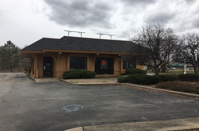
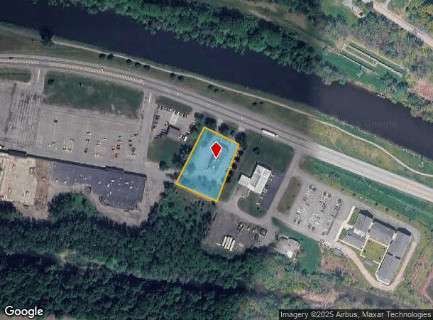
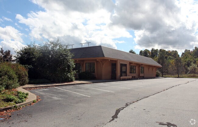
Property Record
1920 State Route 31, Macedon, NY 14502
NEARBY LISTINGS FOR SALE OR LEASE
Property Detail
1920 State Route 31
Rochester, NY
31111-00-237900
543000-063-111-0000-266-903-0000
Wayne
Restaurantdrivein
New York
2025
266.903
2024
1.19 AC
020302
Wayne County
3,074 SF
Rochester
DEMOGRAPHICS near 1920 State Route 31
1 Mile
3 Mile
5 Mile
2024 Total Population
857
8,896
20,520
2029 Population
854
8,869
20,385
Pop Growth 2024-2029
(0.35%)
(0.30%)
(0.66%)
Average Age
45
43
42
2024 Total Households
383
3,832
8,424
HH Growth 2024-2029
(0.52%)
(0.37%)
(0.71%)
Median Household Inc
$67,125
$72,379
$76,402
Avg Household Size
2.20
2.30
2.40
2024 Avg HH Vehicles
2.00
2.00
2.00
Median Home Value
$150,000
$158,591
$167,106
Median Year Built
1984
1968
1975
Nearby Places
- Restaurants
- Banks
- Shops
- Fitness
- Groceries
PUBLIC TRANSPORTATION
AIRPORT
Frederick Douglass/Greater Rochester International
DRIVE
WALK
Distance
Frederick Douglass/Greater Rochester International
36 min
22.0 mi
SALE & LEASE HISTORY
LISTING DATE
SALE/LEASE

Sep 24, 2016
For Sale
Sep 12, 2017
For Sale
Nov 17, 2021
For Sale
Mar 13, 2017
For Sale
Apr 17, 2018
For Lease
Apr 17, 2018
For Sale
Nearby Properties
Address
Land Use
TOTAL SIZE
Lot Size
Zoning
Address
Land Use
TOTAL SIZE
Lot Size
Zoning
11,144 SF
24.17 AC
05 - COMME
Address
Land Use
TOTAL SIZE
Lot Size
Zoning
2.73 AC
Address
Land Use
TOTAL SIZE
Lot Size
Zoning
88,818 SF
7.67 AC
Address
Land Use
TOTAL SIZE
Lot Size
Zoning
126,403 SF
5.86 AC
R1
Address
Land Use
TOTAL SIZE
Lot Size
Zoning
110,254 SF
16.08 AC
R1
Address
Land Use
TOTAL SIZE
Lot Size
Zoning
25,541 SF
3.14 AC
05 - COMME
Address
Land Use
TOTAL SIZE
Lot Size
Zoning
77.84 AC
AR
Address
Land Use
TOTAL SIZE
Lot Size
Zoning
0.52 AC
Address
Land Use
TOTAL SIZE
Lot Size
Zoning
39.40 AC
Address
Land Use
TOTAL SIZE
Lot Size
Zoning
16,000 SF
6.29 AC
Address
Land Use
TOTAL SIZE
Lot Size
Zoning
55,180 SF
22.91 AC
05 - COMME
Address
Land Use
TOTAL SIZE
Lot Size
Zoning
61,044 SF
3.33 AC
R2
Address
Land Use
TOTAL SIZE
Lot Size
Zoning
910 SF
22 AC
RR
Address
Land Use
TOTAL SIZE
Lot Size
Zoning
44.80 AC
Address
Land Use
TOTAL SIZE
Lot Size
Zoning
10,125 SF
2.42 AC
Address
Land Use
TOTAL SIZE
Lot Size
Zoning
110,360 SF
8.45 AC
GC
Address
Land Use
TOTAL SIZE
Lot Size
Zoning
69,078 SF
6.80 AC
05 - COMME
Address
Land Use
TOTAL SIZE
Lot Size
Zoning
6,080 SF
16.15 AC
R1
Address
Land Use
TOTAL SIZE
Lot Size
Zoning
63,806 SF
3.93 AC
06 - INDUS
Address
Land Use
TOTAL SIZE
Lot Size
Zoning
18,938 SF
58.50 AC
ORM
Address
Land Use
TOTAL SIZE
Lot Size
Zoning
65,195 SF
1.27 AC
C1
Address
Land Use
TOTAL SIZE
Lot Size
Zoning
11,600 SF
39.67 AC
Address
Land Use
TOTAL SIZE
Lot Size
Zoning
7,825 SF
2.57 AC
GC
Address
Land Use
TOTAL SIZE
Lot Size
Zoning
16,628 SF
3.13 AC
05 - COMME
Address
Land Use
TOTAL SIZE
Lot Size
Zoning
12,528 SF
1.75 AC
C1
Address
Land Use
TOTAL SIZE
Lot Size
Zoning
5,400 SF
155.32 AC
Address
Land Use
TOTAL SIZE
Lot Size
Zoning
4,000 SF
10.30 AC
Address
Land Use
TOTAL SIZE
Lot Size
Zoning
15,400 SF
30.16 AC
R1
Address
Land Use
TOTAL SIZE
Lot Size
Zoning
8,824 SF
4.03 AC
05 - COMME
Address
Land Use
TOTAL SIZE
Lot Size
Zoning
3,622 SF
4.20 AC
05 - COMME
The World's #1 Commercial Real Estate Marketplace
Connect with us
© 2025 CoStar Group
The information above has been obtained from sources believed reliable. While we do not doubt its accuracy we have not verified it and make no guarantee, warranty or representation about it. It is your responsibility to independently confirm its accuracy and completeness. Any projections, opinions, assumptions, or estimates used are for example only and do not represent the current or future performance of the property. The value of this transaction to you depends on tax and other factors which should be evaluated by your tax, financial, and legal advisors. You and your advisors should conduct a careful, independent investigation of the property to determine to your satisfaction the suitability of the property for your needs.