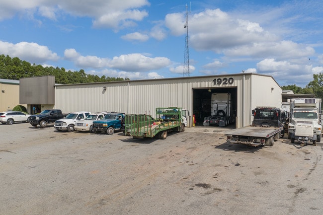
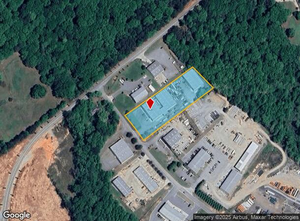
Property Record
1920 Statham Dr, Statham, GA 30666
NEARBY LISTINGS FOR SALE OR LEASE
Property Detail
1920 Statham Dr
Atlanta-Sandy Springs-Roswell, GA
Oakcrest Estates Unit 1
ST02-090C
PB 51-70 LOT 3 BLK A STATHAM IND PARK LANDLOT: RES
Warehouse
Barrow
X
Georgia
13013C0155D
3
2025
2.57 AC
2025
S Barrow
180402
Atlanta
10,000 SF
DEMOGRAPHICS near 1920 Statham Dr
1 Mile
3 Mile
5 Mile
2024 Total Population
1,917
12,770
28,193
2029 Population
2,256
14,950
32,734
Pop Growth 2024-2029
+ 17.68%
+ 17.07%
+ 16.11%
Average Age
38
38
38
2024 Total Households
677
4,480
9,783
HH Growth 2024-2029
+ 17.87%
+ 17.34%
+ 16.23%
Median Household Inc
$56,275
$71,597
$76,039
Avg Household Size
2.80
2.80
2.80
2024 Avg HH Vehicles
2.00
2.00
2.00
Median Home Value
$222,778
$259,326
$254,992
Median Year Built
1998
2004
2003
Nearby Places
Map Layers
Map Styles
 Street
 Aerial
- Restaurants
- Banks
- Shops
- Fitness
- Groceries
SALE & LEASE HISTORY
LISTING DATE
SALE/LEASE

Jan 11, 2018
For Lease
Nearby Properties
Address
Land Use
TOTAL SIZE
Lot Size
Zoning
Address
Land Use
TOTAL SIZE
Lot Size
Zoning
87,278 SF
43.43 AC
A-1
Address
Land Use
TOTAL SIZE
Lot Size
Zoning
398,490 SF
56.68 AC
M-1
Address
Land Use
TOTAL SIZE
Lot Size
Zoning
Address
Land Use
TOTAL SIZE
Lot Size
Zoning
160,000 SF
29.44 AC
O-I
Address
Land Use
TOTAL SIZE
Lot Size
Zoning
27,337 SF
60 AC
M-2
Address
Land Use
TOTAL SIZE
Lot Size
Zoning
30,056 SF
311.73 AC
R-2
Address
Land Use
TOTAL SIZE
Lot Size
Zoning
224,093 SF
17.12 AC
LI
Address
Land Use
TOTAL SIZE
Lot Size
Zoning
12,032 SF
6.30 AC
MFR
Address
Land Use
TOTAL SIZE
Lot Size
Zoning
33,704 SF
14.25 AC
O-I
Address
Land Use
TOTAL SIZE
Lot Size
Zoning
41,916 SF
16.11 AC
LI
Address
Land Use
TOTAL SIZE
Lot Size
Zoning
2,800 SF
5.32 AC
O-I
Address
Land Use
TOTAL SIZE
Lot Size
Zoning
25,044 SF
9.01 AC
M-1
Address
Land Use
TOTAL SIZE
Lot Size
Zoning
24,222 SF
3.81 AC
O-I
Address
Land Use
TOTAL SIZE
Lot Size
Zoning
20,891 SF
3.10 AC
HB
Address
Land Use
TOTAL SIZE
Lot Size
Zoning
1,421 SF
6.09 AC
R-2
Address
Land Use
TOTAL SIZE
Lot Size
Zoning
7,500 SF
3 AC
LI
Address
Land Use
TOTAL SIZE
Lot Size
Zoning
6,159 SF
0.32 AC
R-1-MPD
Address
Land Use
TOTAL SIZE
Lot Size
Zoning
3,498 SF
89.27 AC
AG
Address
Land Use
TOTAL SIZE
Lot Size
Zoning
984 SF
2.07 AC
HB
Address
Land Use
TOTAL SIZE
Lot Size
Zoning
80.95 AC
AG
Address
Land Use
TOTAL SIZE
Lot Size
Zoning
26,400 SF
13.38 AC
M-1
Address
Land Use
TOTAL SIZE
Lot Size
Zoning
64,733 SF
1.58 AC
CB
Address
Land Use
TOTAL SIZE
Lot Size
Zoning
8,821 SF
10.90 AC
AG
Address
Land Use
TOTAL SIZE
Lot Size
Zoning
3,200 SF
3.43 AC
M-1
Address
Land Use
TOTAL SIZE
Lot Size
Zoning
5,203 SF
0.32 AC
R-1-MPD
Address
Land Use
TOTAL SIZE
Lot Size
Zoning
6,869 SF
0.90 AC
R-2
Address
Land Use
TOTAL SIZE
Lot Size
Zoning
18,865 SF
0.46 AC
HR
Address
Land Use
TOTAL SIZE
Lot Size
Zoning
84.74 AC
AG
Address
Land Use
TOTAL SIZE
Lot Size
Zoning
50.42 AC
AG
The World's #1 Commercial Real Estate Marketplace
Connect with us
© 2025 CoStar Group
The information above has been obtained from sources believed reliable. While we do not doubt its accuracy we have not verified it and make no guarantee, warranty or representation about it. It is your responsibility to independently confirm its accuracy and completeness. Any projections, opinions, assumptions, or estimates used are for example only and do not represent the current or future performance of the property. The value of this transaction to you depends on tax and other factors which should be evaluated by your tax, financial, and legal advisors. You and your advisors should conduct a careful, independent investigation of the property to determine to your satisfaction the suitability of the property for your needs.