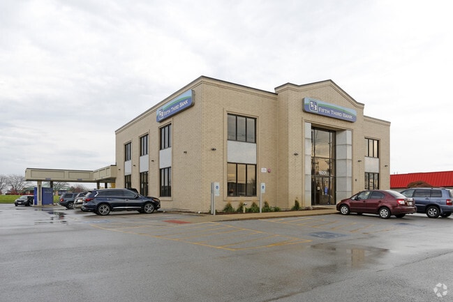
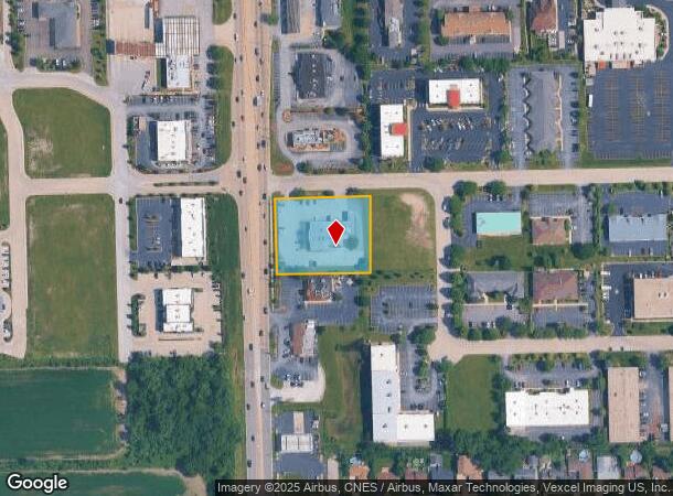
Property Record
19201 S La Grange Rd, Mokena, IL 60448
Current Lease Availabilities
NEARBY LISTINGS FOR SALE OR LEASE
Property Detail
19201 S La Grange Rd
Chicago-Naperville-Elgin, IL-IN-WI
La Grange Ridge
19-09-10-102-016
LOT 13 IN LA GRANGE RIDGE BUSINESS PARK, BEING A SUB OF PRT OF THE W1/2 OF THE NW1/4 OF SEC. 10, T35N-R12E.
Commercialnec
Will
X
Illinois
17197C0211G
13
2024
1.20 AC
2024
Joliet/Central Will
883513
Chicago
10,923 SF
DEMOGRAPHICS near 19201 S La Grange Rd
1 Mile
3 Mile
5 Mile
2024 Total Population
5,537
59,944
151,546
2029 Population
5,499
59,138
148,864
Pop Growth 2024-2029
(0.69%)
(1.34%)
(1.77%)
Average Age
41
43
43
2024 Total Households
1,906
21,529
55,884
HH Growth 2024-2029
(0.68%)
(1.45%)
(2.07%)
Median Household Inc
$119,905
$115,478
$102,119
Avg Household Size
2.90
2.70
2.70
2024 Avg HH Vehicles
2.00
2.00
2.00
Median Home Value
$329,480
$327,474
$307,583
Median Year Built
1994
1993
1991
Nearby Places
- Restaurants
- Banks
- Shops
- Fitness
- Groceries
PUBLIC TRANSPORTATION
COMMUTER RAIL
Hickory Creek (Rock Island - Metra)
DRIVE
WALK
Distance
Hickory Creek (Rock Island - Metra)
3 min
15 min
0.8 mi
Mokena/Front Street Station (Rock Island District Line - Northeast Illinois Regional Commuter Railroad (Metra))
DRIVE
WALK
Distance
Mokena/Front Street Station (Rock Island District Line - Northeast Illinois Regional Commuter Railroad (Metra))
7 min
3.3 mi
AIRPORT
Chicago Midway International
DRIVE
WALK
Distance
Chicago Midway International
35 min
22.6 mi
Freight Ports
Port Milwaukee
DRIVE
WALK
Distance
Port Milwaukee
137 min
109.9 mi
Nearby Properties
Address
Land Use
TOTAL SIZE
Lot Size
Zoning
Address
Land Use
TOTAL SIZE
Lot Size
Zoning
30.10 AC
Address
Land Use
TOTAL SIZE
Lot Size
Zoning
68,954 SF
Address
Land Use
TOTAL SIZE
Lot Size
Zoning
103,663 SF
13.06 AC
Address
Land Use
TOTAL SIZE
Lot Size
Zoning
79,455 SF
5.36 AC
Address
Land Use
TOTAL SIZE
Lot Size
Zoning
304,608 SF
19.51 AC
Address
Land Use
TOTAL SIZE
Lot Size
Zoning
168,708 SF
14.74 AC
Address
Land Use
TOTAL SIZE
Lot Size
Zoning
Address
Land Use
TOTAL SIZE
Lot Size
Zoning
238,068 SF
13.96 AC
Address
Land Use
TOTAL SIZE
Lot Size
Zoning
200,815 SF
10 AC
Address
Land Use
TOTAL SIZE
Lot Size
Zoning
216,900 SF
10.11 AC
Address
Land Use
TOTAL SIZE
Lot Size
Zoning
23.67 AC
Address
Land Use
TOTAL SIZE
Lot Size
Zoning
8.50 AC
Address
Land Use
TOTAL SIZE
Lot Size
Zoning
77,290 SF
10.23 AC
Address
Land Use
TOTAL SIZE
Lot Size
Zoning
92,499 SF
5.29 AC
Address
Land Use
TOTAL SIZE
Lot Size
Zoning
113,474 SF
19.83 AC
Address
Land Use
TOTAL SIZE
Lot Size
Zoning
77,779 SF
1.65 AC
Address
Land Use
TOTAL SIZE
Lot Size
Zoning
106,359 SF
8.25 AC
Address
Land Use
TOTAL SIZE
Lot Size
Zoning
40,000 SF
4.98 AC
Address
Land Use
TOTAL SIZE
Lot Size
Zoning
126,480 SF
10.58 AC
Address
Land Use
TOTAL SIZE
Lot Size
Zoning
8.76 AC
Address
Land Use
TOTAL SIZE
Lot Size
Zoning
70,848 SF
10.18 AC
Address
Land Use
TOTAL SIZE
Lot Size
Zoning
8,826 SF
61.49 AC
Address
Land Use
TOTAL SIZE
Lot Size
Zoning
55,435 SF
6.43 AC
Address
Land Use
TOTAL SIZE
Lot Size
Zoning
113,936 SF
6.96 AC
Address
Land Use
TOTAL SIZE
Lot Size
Zoning
63,239 SF
9.25 AC
Address
Land Use
TOTAL SIZE
Lot Size
Zoning
53,072 SF
0.63 AC
Address
Land Use
TOTAL SIZE
Lot Size
Zoning
97,318 SF
9.80 AC
Address
Land Use
TOTAL SIZE
Lot Size
Zoning
125,016 SF
6.63 AC
Address
Land Use
TOTAL SIZE
Lot Size
Zoning
4.62 AC
Address
Land Use
TOTAL SIZE
Lot Size
Zoning
48,238 SF
5.17 AC
The World's #1 Commercial Real Estate Marketplace
Connect with us
© 2025 CoStar Group
The information above has been obtained from sources believed reliable. While we do not doubt its accuracy we have not verified it and make no guarantee, warranty or representation about it. It is your responsibility to independently confirm its accuracy and completeness. Any projections, opinions, assumptions, or estimates used are for example only and do not represent the current or future performance of the property. The value of this transaction to you depends on tax and other factors which should be evaluated by your tax, financial, and legal advisors. You and your advisors should conduct a careful, independent investigation of the property to determine to your satisfaction the suitability of the property for your needs.