Property Record
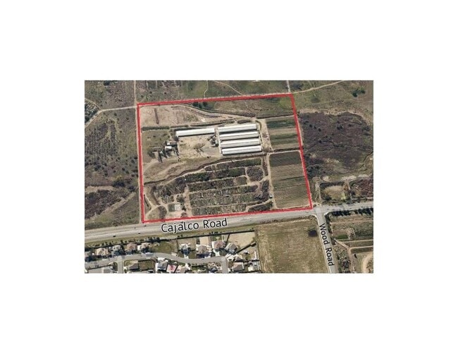
19203 Cajalco Rd, Perris, CA 92570

This Property Is For Sale
Property Detail
19203 Cajalco Rd
321-140-034
2.07 ACRES M/L IN POR SW 1/4 OF SEC 8 T4S R4W FOR TOTAL DESCRIPTION SEE ASSESSORS MAPS
Agriculturalland
RIVERSIDE
RA12
California
A Areas with a 1% annual chance of flooding and a 26% chance of flooding over the life of a 30-year mortgage.
22.33 AC
2024
Moreno Valley/Perris
2025
Inland Empire (California)
042903
Riverside-San Bernardino-Ontario, CA
1,300 SF
NEARBY LISTINGS FOR SALE OR LEASE
DEMOGRAPHICS near 19203 Cajalco Rd
1 mile
3 mile
5 mile
2025 Total Population
1,531
24,011
66,260
2030 Population
1,556
24,637
67,798
Pop Growth 2025-2030
+ 1.63%
+ 2.61%
+ 2.32%
Average Age
38
37
38
2025 Total Households
392
5,982
17,843
HH Growth 2025-2030
+ 1.02%
+ 2.32%
+ 2.07%
Median Household Inc
$115,961
$97,590
$117,466
Avg Household Size
3.60
3.70
3.50
2025 Avg HH Vehicles
3.00
3.00
3.00
Median Home Value
$810,141
$663,418
$708,900
Median Year Built
2000
1987
1990
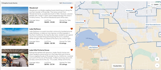
Nearby Places
Map Layers
Map Styles
 Street
 Aerial
Layers
 Traffic
 Biking
Places
Listings with unknown addresses are not visible on the map
- Restaurants
- Banks
- Shops
- Fitness
- Groceries
PUBLIC TRANSPORTATION
COMMUTER RAIL
Drive
Walk
Distance
14 min
9.1 mi
AIRPORT
Ontario International
Drive
Walk
Distance
Ontario International
44 min
26.8 mi
John Wayne/Orange County
Drive
Walk
Distance
John Wayne/Orange County
62 min
47.3 mi
Nearby Properties
Address
Land Use
TOTAL SIZE
Lot Size
Zoning
Address
Land Use
TOTAL SIZE
Lot Size
Zoning
57.73 AC
RA12
Address
Land Use
TOTAL SIZE
Lot Size
Zoning
4,841 SF
1.14 AC
Address
Land Use
TOTAL SIZE
Lot Size
Zoning
4,629 SF
10.05 AC
RA
Address
Land Use
TOTAL SIZE
Lot Size
Zoning
252 SF
3.86 AC
A1
Address
Land Use
TOTAL SIZE
Lot Size
Zoning
8,346 SF
2.12 AC
Address
Land Use
TOTAL SIZE
Lot Size
Zoning
13,330 SF
4.80 AC
A11
Address
Land Use
TOTAL SIZE
Lot Size
Zoning
1,152 SF
203 AC
RR12
Address
Land Use
TOTAL SIZE
Lot Size
Zoning
9.20 AC
A110
Address
Land Use
TOTAL SIZE
Lot Size
Zoning
7,641 SF
2.41 AC
Address
Land Use
TOTAL SIZE
Lot Size
Zoning
9,036 SF
4.39 AC
RA
Address
Land Use
TOTAL SIZE
Lot Size
Zoning
65 AC
RA1
Address
Land Use
TOTAL SIZE
Lot Size
Zoning
150 AC
RR
Address
Land Use
TOTAL SIZE
Lot Size
Zoning
2,529 SF
15.15 AC
AP
Address
Land Use
TOTAL SIZE
Lot Size
Zoning
3,170 SF
0.76 AC
CPS
Address
Land Use
TOTAL SIZE
Lot Size
Zoning
5,467 SF
4.29 AC
Address
Land Use
TOTAL SIZE
Lot Size
Zoning
5,880 SF
1.38 AC
Address
Land Use
TOTAL SIZE
Lot Size
Zoning
2,310 SF
80 AC
CBOOK
Address
Land Use
TOTAL SIZE
Lot Size
Zoning
6,834 SF
0.93 AC
Address
Land Use
TOTAL SIZE
Lot Size
Zoning
6,143 SF
1.74 AC
CPS
Address
Land Use
TOTAL SIZE
Lot Size
Zoning
3,822 SF
10 AC
RT
Address
Land Use
TOTAL SIZE
Lot Size
Zoning
8.23 AC
RA212
Address
Land Use
TOTAL SIZE
Lot Size
Zoning
31.14 AC
A15
The World's #1 Commercial Real Estate Marketplace
Connect with us
© 2026 CoStar Group
The information above has been obtained from sources believed reliable. While we do not doubt its accuracy we have not verified it and make no guarantee, warranty or representation about it. It is your responsibility to independently confirm its accuracy and completeness. Any projections, opinions, assumptions, or estimates used are for example only and do not represent the current or future performance of the property. The value of this transaction to you depends on tax and other factors which should be evaluated by your tax, financial, and legal advisors. You and your advisors should conduct a careful, independent investigation of the property to determine to your satisfaction the suitability of the property for your needs.