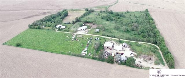
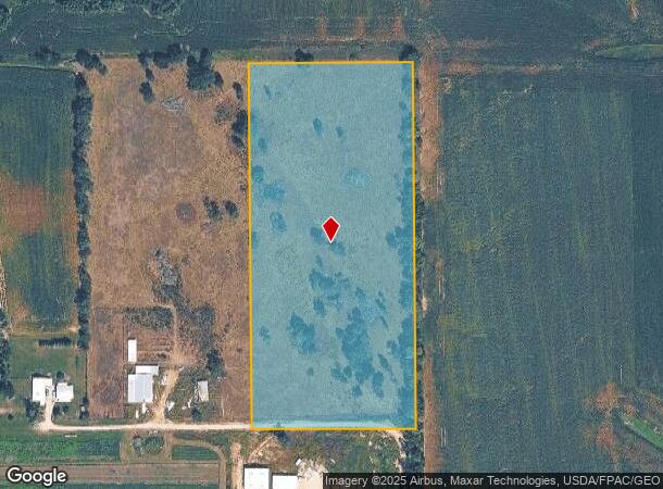
Property Record
19204 State St, Bennington, NE 68007
NEARBY LISTINGS FOR SALE OR LEASE
Property Detail
19204 State St
Omaha, NE-IA
Lands
2254-0014-01
LANDS SEC-TWN-RGE 19-16-11 -EX W 880 FT- N 990 FT NE 1/4 SE 1/4
Agriculturalland
Douglas
X
Nebraska
31055C0179J
10 AC
2024
Northwest Omaha
2025
Omaha/Council Bluffs
007505
DEMOGRAPHICS near 19204 State St
1 mile
3 mile
5 mile
2024 Total Population
141
14,379
69,646
2029 Population
143
15,193
71,685
Pop Growth 2024-2029
+ 1.42%
+ 5.66%
+ 2.93%
Average Age
40
35
36
2024 Total Households
46
4,522
24,953
HH Growth 2024-2029
0.00%
+ 5.62%
+ 2.85%
Median Household Inc
$149,999
$132,676
$115,150
Avg Household Size
3.00
3.10
2.80
2024 Avg HH Vehicles
3.00
2.00
2.00
Median Home Value
$576,087
$381,645
$319,379
Median Year Built
1988
2010
2008
Nearby Places
Map Layers
Map Styles
 Street
 Aerial
Transit
 Traffic
 Biking
Places
Listings with unknown addresses are not visible on the map
- Restaurants
- Banks
- Shops
- Fitness
- Groceries
PUBLIC TRANSPORTATION
AIRPORT
Eppley Airfield
Drive
Walk
Distance
Eppley Airfield
41 min
21.2 mi
Freight Ports
Tulsa Port Of Catoosa
Drive
Walk
Distance
Tulsa Port Of Catoosa
492 min
438.0 mi
SALE & LEASE HISTORY
LISTING DATE
SALE/LEASE

Jun 29, 2017
For Sale
Nearby Properties
Address
Land Use
TOTAL SIZE
Lot Size
Zoning
Address
Land Use
TOTAL SIZE
Lot Size
Zoning
320,111 SF
19.17 AC
R4
Address
Land Use
TOTAL SIZE
Lot Size
Zoning
301,689 SF
8.82 AC
Address
Land Use
TOTAL SIZE
Lot Size
Zoning
228,963 SF
7.36 AC
Address
Land Use
TOTAL SIZE
Lot Size
Zoning
57,360 SF
3.62 AC
Address
Land Use
TOTAL SIZE
Lot Size
Zoning
47,770 SF
20 AC
AF1
Address
Land Use
TOTAL SIZE
Lot Size
Zoning
12,748 SF
2.65 AC
Address
Land Use
TOTAL SIZE
Lot Size
Zoning
13,045 SF
1.36 AC
Address
Land Use
TOTAL SIZE
Lot Size
Zoning
26,736 SF
8.46 AC
Address
Land Use
TOTAL SIZE
Lot Size
Zoning
25,618 SF
1.91 AC
Address
Land Use
TOTAL SIZE
Lot Size
Zoning
12,451 SF
0.57 AC
Address
Land Use
TOTAL SIZE
Lot Size
Zoning
22,123 SF
0.90 AC
Address
Land Use
TOTAL SIZE
Lot Size
Zoning
22,610 SF
1.87 AC
Address
Land Use
TOTAL SIZE
Lot Size
Zoning
12,519 SF
0.62 AC
BENNINGTON
Address
Land Use
TOTAL SIZE
Lot Size
Zoning
12,975 SF
1.97 AC
Address
Land Use
TOTAL SIZE
Lot Size
Zoning
12,053 SF
1 AC
Address
Land Use
TOTAL SIZE
Lot Size
Zoning
13,674 SF
1.18 AC
Address
Land Use
TOTAL SIZE
Lot Size
Zoning
18,212 SF
0.99 AC
Address
Land Use
TOTAL SIZE
Lot Size
Zoning
13,152 SF
11.65 AC
AG
Address
Land Use
TOTAL SIZE
Lot Size
Zoning
12,345 SF
1.01 AC
BENNINGTON
Address
Land Use
TOTAL SIZE
Lot Size
Zoning
9,873 SF
1.01 AC
Address
Land Use
TOTAL SIZE
Lot Size
Zoning
9,858 SF
0.60 AC
Address
Land Use
TOTAL SIZE
Lot Size
Zoning
10,720 SF
1.46 AC
R1
Address
Land Use
TOTAL SIZE
Lot Size
Zoning
12.19 AC
Address
Land Use
TOTAL SIZE
Lot Size
Zoning
10,575 SF
0.52 AC
Address
Land Use
TOTAL SIZE
Lot Size
Zoning
11,860 SF
1.39 AC
Address
Land Use
TOTAL SIZE
Lot Size
Zoning
10,308 SF
1.03 AC
Address
Land Use
TOTAL SIZE
Lot Size
Zoning
11,434 SF
14.94 AC
Address
Land Use
TOTAL SIZE
Lot Size
Zoning
10,980 SF
1.30 AC
Address
Land Use
TOTAL SIZE
Lot Size
Zoning
9,937 SF
0.58 AC
Address
Land Use
TOTAL SIZE
Lot Size
Zoning
14,785 SF
23.53 AC
The World's #1 Commercial Real Estate Marketplace
Connect with us
© 2026 CoStar Group
The information above has been obtained from sources believed reliable. While we do not doubt its accuracy we have not verified it and make no guarantee, warranty or representation about it. It is your responsibility to independently confirm its accuracy and completeness. Any projections, opinions, assumptions, or estimates used are for example only and do not represent the current or future performance of the property. The value of this transaction to you depends on tax and other factors which should be evaluated by your tax, financial, and legal advisors. You and your advisors should conduct a careful, independent investigation of the property to determine to your satisfaction the suitability of the property for your needs.