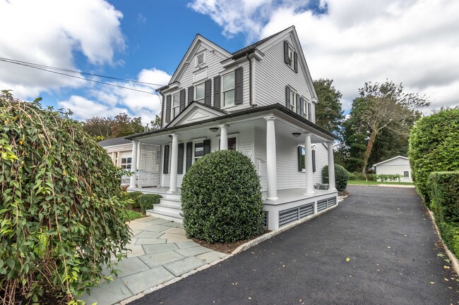
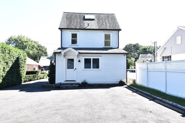
Property Record
1921 Post Rd, Darien, CT 06820

Property Detail
1921 Post Rd
Governmentalpublicusegeneral
FAIRFIELD
NB
Connecticut
B and X Area of moderate flood hazard, usually the area between the limits of the 100-year and 500-year floods.
0.12 AC
2025
Darien
2025
Westchester/So Connecticut
030400
Bridgeport-Stamford-Danbury, CT
1,456 SF
DARI-000042-000000-000004
NEARBY LISTINGS FOR SALE OR LEASE
DEMOGRAPHICS near 1921 Post Rd
1 mile
3 mile
5 mile
2025 Total Population
6,797
93,086
205,254
2030 Population
7,003
95,598
210,125
Pop Growth 2025-2030
+ 3.03%
+ 2.70%
+ 2.37%
Average Age
39
39
40
2025 Total Households
2,209
36,820
78,813
HH Growth 2025-2030
+ 2.99%
+ 2.89%
+ 2.57%
Median Household Inc
$244,296
$115,006
$111,394
Avg Household Size
3.10
2.40
2.50
2025 Avg HH Vehicles
2.00
2.00
2.00
Median Home Value
$1,110,000
$795,004
$758,268
Median Year Built
1956
1969
1969
Nearby Places
Map Layers
Map Styles
 Street
 Aerial
Transit
 Traffic
 Biking
Places
Listings with unknown addresses are not visible on the map
- Restaurants
- Banks
- Shops
- Fitness
- Groceries
PUBLIC TRANSPORTATION
COMMUTER RAIL
Noroton Heights Station (New Haven Line - Metro-North Commuter Railroad Company (Metro-North))
Drive
Walk
Distance
Noroton Heights Station (New Haven Line - Metro-North Commuter Railroad Company (Metro-North))
2 min
20 min
1.1 mi
Darien Station (New Haven Line - Metro-North Commuter Railroad Company (Metro-North))
Drive
Walk
Distance
Darien Station (New Haven Line - Metro-North Commuter Railroad Company (Metro-North))
3 min
1.5 mi
AIRPORT
Westchester County
Drive
Walk
Distance
Westchester County
26 min
15.7 mi
LaGuardia
Drive
Walk
Distance
LaGuardia
53 min
35.0 mi
Freight Ports
Port of New Haven
Drive
Walk
Distance
Port of New Haven
55 min
38.4 mi
SALE & LEASE HISTORY
LISTING DATE
SALE/LEASE

Oct 15, 2018
For Sale
May 18, 2023
For Sale
Jan 12, 2023
For Sale
Feb 22, 2019
For Lease
Feb 19, 2019
For Lease
Apr 17, 2023
For Lease
Apr 16, 2019
For Lease
Nearby Properties
Address
Land Use
TOTAL SIZE
Lot Size
Zoning
Address
Land Use
TOTAL SIZE
Lot Size
Zoning
8.91 AC
DC
Address
Land Use
TOTAL SIZE
Lot Size
Zoning
336,000 SF
40 AC
MU
Address
Land Use
TOTAL SIZE
Lot Size
Zoning
5.10 AC
MXD
Address
Land Use
TOTAL SIZE
Lot Size
Zoning
Address
Land Use
TOTAL SIZE
Lot Size
Zoning
543,005 SF
2.23 AC
RHD
Address
Land Use
TOTAL SIZE
Lot Size
Zoning
4.13 AC
CC
Address
Land Use
TOTAL SIZE
Lot Size
Zoning
46,302 SF
23.50 AC
MG
Address
Land Use
TOTAL SIZE
Lot Size
Zoning
9.62 AC
MZN
Address
Land Use
TOTAL SIZE
Lot Size
Zoning
359,686 SF
1.67 AC
CCN
Address
Land Use
TOTAL SIZE
Lot Size
Zoning
377,754 SF
2.06 AC
PD
Address
Land Use
TOTAL SIZE
Lot Size
Zoning
79.29 AC
P
Address
Land Use
TOTAL SIZE
Lot Size
Zoning
32.68 AC
MD
Address
Land Use
TOTAL SIZE
Lot Size
Zoning
8.21 AC
CWD
Address
Land Use
TOTAL SIZE
Lot Size
Zoning
304,617 SF
CI
Address
Land Use
TOTAL SIZE
Lot Size
Zoning
304,345 SF
1.15 AC
PD
Address
Land Use
TOTAL SIZE
Lot Size
Zoning
308,621 SF
CI
Address
Land Use
TOTAL SIZE
Lot Size
Zoning
32.06 AC
DMR
Address
Land Use
TOTAL SIZE
Lot Size
Zoning
235,186 SF
1.29 AC
CG
Address
Land Use
TOTAL SIZE
Lot Size
Zoning
3.14 AC
RH
Address
Land Use
TOTAL SIZE
Lot Size
Zoning
243,000 SF
3.02 AC
CG
Address
Land Use
TOTAL SIZE
Lot Size
Zoning
334,905 SF
2.52 AC
MXD
Address
Land Use
TOTAL SIZE
Lot Size
Zoning
4.53 AC
RH
Address
Land Use
TOTAL SIZE
Lot Size
Zoning
5.18 AC
CC
Address
Land Use
TOTAL SIZE
Lot Size
Zoning
42.18 AC
P
Address
Land Use
TOTAL SIZE
Lot Size
Zoning
229,644 SF
3.12 AC
RH
Address
Land Use
TOTAL SIZE
Lot Size
Zoning
236,713 SF
3.21 AC
RMF
Address
Land Use
TOTAL SIZE
Lot Size
Zoning
456,159 SF
4.24 AC
CC
Address
Land Use
TOTAL SIZE
Lot Size
Zoning
13.56 AC
R75
Address
Land Use
TOTAL SIZE
Lot Size
Zoning
267,935 SF
2.50 AC
CC
Address
Land Use
TOTAL SIZE
Lot Size
Zoning
3.59 AC
RH
The World's #1 Commercial Real Estate Marketplace
Connect with us
© 2026 CoStar Group
The information above has been obtained from sources believed reliable. While we do not doubt its accuracy we have not verified it and make no guarantee, warranty or representation about it. It is your responsibility to independently confirm its accuracy and completeness. Any projections, opinions, assumptions, or estimates used are for example only and do not represent the current or future performance of the property. The value of this transaction to you depends on tax and other factors which should be evaluated by your tax, financial, and legal advisors. You and your advisors should conduct a careful, independent investigation of the property to determine to your satisfaction the suitability of the property for your needs.