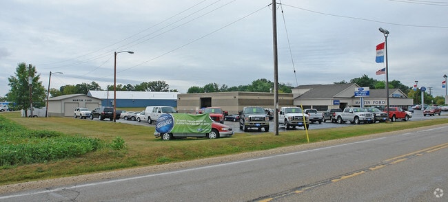
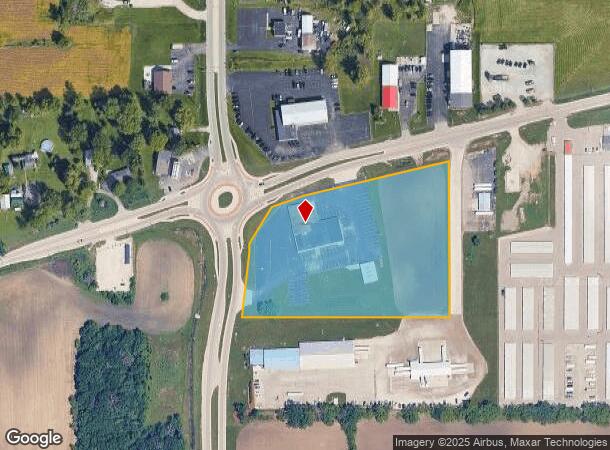
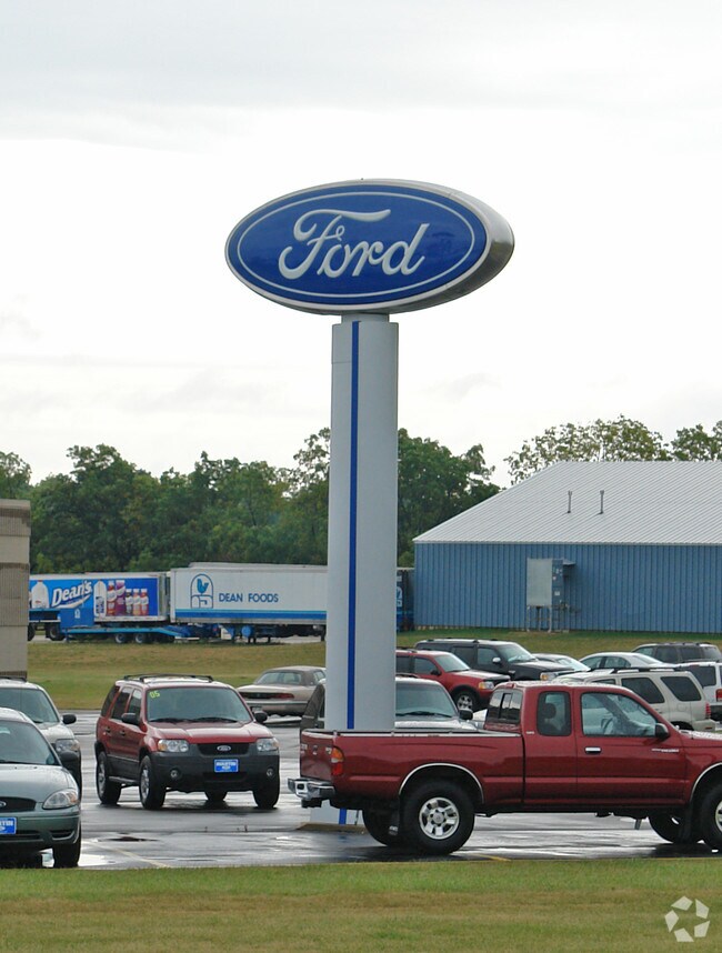
Property Record
19215 Spring St, Union Grove, WI 53182
NEARBY LISTINGS FOR SALE OR LEASE
-
-
View all Union Grove listings for sale on LoopNet.com
Property Detail
19215 Spring St
194-032120020000
PT SW1/4 COM W1/4 COR S886 NE64 TO POB NE195 NE518 S477 W477 N187 W150 N19 TO POB & COM W1/4 COR S886 NE260 NE668 S794 W773 N
Commercialnec
Racine
X
Wisconsin
55101C0183D
5 AC
2024
Racine East
2024
Milwaukee/Madison
001801
Racine-Mount Pleasant, WI
DEMOGRAPHICS near 19215 Spring St
1 Mile
3 Mile
5 Mile
2024 Total Population
674
7,705
12,539
2029 Population
666
7,700
12,471
Pop Growth 2024-2029
(1.19%)
(0.06%)
(0.54%)
Average Age
42
41
42
2024 Total Households
256
2,743
4,647
HH Growth 2024-2029
(0.78%)
(0.04%)
(0.56%)
Median Household Inc
$83,833
$91,397
$92,414
Avg Household Size
2.50
2.50
2.50
2024 Avg HH Vehicles
2.00
2.00
2.00
Median Home Value
$325,000
$298,597
$319,989
Median Year Built
1978
1973
1972
Nearby Places
Map Layers
Map Styles
 Street
 Aerial
- Restaurants
- Banks
- Shops
- Fitness
- Groceries
PUBLIC TRANSPORTATION
COMMUTER RAIL
Sturtevant Amtrak Station (Hiawatha Service - Amtrak)
DRIVE
WALK
Distance
Sturtevant Amtrak Station (Hiawatha Service - Amtrak)
14 min
8.1 mi
AIRPORT
General Mitchell International
DRIVE
WALK
Distance
General Mitchell International
32 min
22.7 mi
Freight Ports
Port Milwaukee
DRIVE
WALK
Distance
Port Milwaukee
36 min
26.6 mi
Nearby Properties
Address
Land Use
TOTAL SIZE
Lot Size
Zoning
Address
Land Use
TOTAL SIZE
Lot Size
Zoning
7.12 AC
Address
Land Use
TOTAL SIZE
Lot Size
Zoning
4.15 AC
Address
Land Use
TOTAL SIZE
Lot Size
Zoning
3.04 AC
Address
Land Use
TOTAL SIZE
Lot Size
Zoning
5.54 AC
Address
Land Use
TOTAL SIZE
Lot Size
Zoning
0.05 AC
RM
Address
Land Use
TOTAL SIZE
Lot Size
Zoning
6.23 AC
I2
Address
Land Use
TOTAL SIZE
Lot Size
Zoning
20.02 AC
C1
Address
Land Use
TOTAL SIZE
Lot Size
Zoning
5.03 AC
P1
Address
Land Use
TOTAL SIZE
Lot Size
Zoning
8.38 AC
Address
Land Use
TOTAL SIZE
Lot Size
Zoning
8.38 AC
Address
Land Use
TOTAL SIZE
Lot Size
Zoning
76.91 AC
Address
Land Use
TOTAL SIZE
Lot Size
Zoning
0.80 AC
Address
Land Use
TOTAL SIZE
Lot Size
Zoning
4.55 AC
Address
Land Use
TOTAL SIZE
Lot Size
Zoning
4.61 AC
I2
Address
Land Use
TOTAL SIZE
Lot Size
Zoning
Address
Land Use
TOTAL SIZE
Lot Size
Zoning
12.12 AC
C1
Address
Land Use
TOTAL SIZE
Lot Size
Zoning
2.73 AC
C2
Address
Land Use
TOTAL SIZE
Lot Size
Zoning
30.53 AC
Address
Land Use
TOTAL SIZE
Lot Size
Zoning
151.16 AC
Address
Land Use
TOTAL SIZE
Lot Size
Zoning
0.07 AC
RM
Address
Land Use
TOTAL SIZE
Lot Size
Zoning
4.33 AC
I2
Address
Land Use
TOTAL SIZE
Lot Size
Zoning
0.98 AC
Address
Land Use
TOTAL SIZE
Lot Size
Zoning
0.07 AC
RM
Address
Land Use
TOTAL SIZE
Lot Size
Zoning
4.65 AC
MH
Address
Land Use
TOTAL SIZE
Lot Size
Zoning
0.29 AC
C1
Address
Land Use
TOTAL SIZE
Lot Size
Zoning
Address
Land Use
TOTAL SIZE
Lot Size
Zoning
2.32 AC
Address
Land Use
TOTAL SIZE
Lot Size
Zoning
0.06 AC
RM
Address
Land Use
TOTAL SIZE
Lot Size
Zoning
31.28 AC
Address
Land Use
TOTAL SIZE
Lot Size
Zoning
3.91 AC
The World's #1 Commercial Real Estate Marketplace
Connect with us
© 2026 CoStar Group
The information above has been obtained from sources believed reliable. While we do not doubt its accuracy we have not verified it and make no guarantee, warranty or representation about it. It is your responsibility to independently confirm its accuracy and completeness. Any projections, opinions, assumptions, or estimates used are for example only and do not represent the current or future performance of the property. The value of this transaction to you depends on tax and other factors which should be evaluated by your tax, financial, and legal advisors. You and your advisors should conduct a careful, independent investigation of the property to determine to your satisfaction the suitability of the property for your needs.