Property Record
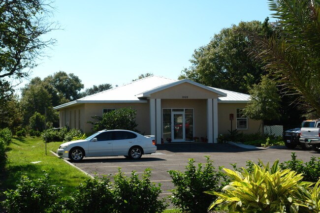
1922 53Rd Ave E, Bradenton, FL 34203

Property Detail
1922 53Rd Ave E
18015-0010-9
A PARCEL OF LAND LYING IN SEC 18, TWN 35S, RNG 18E. COMMENCE AT A NE COR OF THE NE 1/4 OF THE NW 1/4 OF SEC 18; TH W, A DIST OF 613.97 FT; TH S, A DIST OF 33.00 FT FOR A POB: TH E,
Medicalbuilding
Manatee
PR-S PROFE
Florida
B and X Area of moderate flood hazard, usually the area between the limits of the 100-year and 500-year floods.
0.36 AC
2024
Manatee
2025
Tampa/St Petersburg
000805
North Port-Bradenton-Sarasota, FL
2,984 SF
NEARBY LISTINGS FOR SALE OR LEASE
DEMOGRAPHICS near 1922 53Rd Ave E
1 mile
3 mile
5 mile
2025 Total Population
8,439
97,465
211,444
2030 Population
9,319
108,274
235,537
Pop Growth 2025-2030
+ 10.43%
+ 11.09%
+ 11.39%
Average Age
41
43
45
2025 Total Households
3,064
39,634
91,391
HH Growth 2025-2030
+ 10.70%
+ 11.41%
+ 11.76%
Median Household Inc
$45,991
$54,573
$62,640
Avg Household Size
2.50
2.30
2.20
2025 Avg HH Vehicles
2.00
2.00
2.00
Median Home Value
$243,792
$240,536
$317,217
Median Year Built
1987
1981
1984
Nearby Places
Map Layers
Map Styles
 Street
 Aerial
Transit
 Traffic
 Biking
Places
Listings with unknown addresses are not visible on the map
- Restaurants
- Banks
- Shops
- Fitness
- Groceries
PUBLIC TRANSPORTATION
AIRPORT
Sarasota/Bradenton International
Drive
Walk
Distance
Sarasota/Bradenton International
14 min
6.7 mi
St Pete-Clearwater International
Drive
Walk
Distance
St Pete-Clearwater International
54 min
39.3 mi
Freight Ports
Port Manatee
Drive
Walk
Distance
Port Manatee
27 min
15.4 mi
Nearby Properties
Address
Land Use
TOTAL SIZE
Lot Size
Zoning
Address
Land Use
TOTAL SIZE
Lot Size
Zoning
349,711 SF
49.51 AC
BR_SD1
Address
Land Use
TOTAL SIZE
Lot Size
Zoning
385,610 SF
32.65 AC
RMF-6 MULT
Address
Land Use
TOTAL SIZE
Lot Size
Zoning
2,401,721 SF
142.14 AC
PD-UI
Address
Land Use
TOTAL SIZE
Lot Size
Zoning
294,609 SF
19.15 AC
RMF9
Address
Land Use
TOTAL SIZE
Lot Size
Zoning
375,171 SF
20 AC
PD-MU
Address
Land Use
TOTAL SIZE
Lot Size
Zoning
397,863 SF
21.60 AC
GC GENERA
Address
Land Use
TOTAL SIZE
Lot Size
Zoning
247,592 SF
13.39 AC
GC,RMF-6
Address
Land Use
TOTAL SIZE
Lot Size
Zoning
198,036 SF
8.32 AC
GC GENERA
Address
Land Use
TOTAL SIZE
Lot Size
Zoning
115,400 SF
22.55 AC
LM LIGHT M
Address
Land Use
TOTAL SIZE
Lot Size
Zoning
185,617 SF
13.68 AC
BR_R-2
Address
Land Use
TOTAL SIZE
Lot Size
Zoning
359,950 SF
34.91 AC
LM LIGHT M
Address
Land Use
TOTAL SIZE
Lot Size
Zoning
187,000 SF
8.93 AC
Address
Land Use
TOTAL SIZE
Lot Size
Zoning
214,350 SF
16.07 AC
LM LIGHT M
Address
Land Use
TOTAL SIZE
Lot Size
Zoning
296,983 SF
34.84 AC
PD-MU
Address
Land Use
TOTAL SIZE
Lot Size
Zoning
485,150 SF
56.44 AC
HC,GC
Address
Land Use
TOTAL SIZE
Lot Size
Zoning
163,394 SF
15.49 AC
PD-MU
Address
Land Use
TOTAL SIZE
Lot Size
Zoning
318,009 SF
34.60 AC
LM LIGHT M
Address
Land Use
TOTAL SIZE
Lot Size
Zoning
901,196 SF
48.54 AC
LM LIGHT M
Address
Land Use
TOTAL SIZE
Lot Size
Zoning
271,970 SF
31.11 AC
PD-I
Address
Land Use
TOTAL SIZE
Lot Size
Zoning
145,200 SF
8.66 AC
Address
Land Use
TOTAL SIZE
Lot Size
Zoning
148,992 SF
9.81 AC
RMF-9,GC
Address
Land Use
TOTAL SIZE
Lot Size
Zoning
126,505 SF
20 AC
RSF-2
Address
Land Use
TOTAL SIZE
Lot Size
Zoning
112,857 SF
10.12 AC
GC GENERA
Address
Land Use
TOTAL SIZE
Lot Size
Zoning
193,682 SF
10.67 AC
PD-C
Address
Land Use
TOTAL SIZE
Lot Size
Zoning
419,956 SF
18.46 AC
LM LIGHT M
Address
Land Use
TOTAL SIZE
Lot Size
Zoning
145,200 SF
8.99 AC
Address
Land Use
TOTAL SIZE
Lot Size
Zoning
157,713 SF
12.84 AC
GC GENERA
Address
Land Use
TOTAL SIZE
Lot Size
Zoning
124,129 SF
23.29 AC
PDC
Address
Land Use
TOTAL SIZE
Lot Size
Zoning
143,582 SF
14.42 AC
LM LIGHT M
Address
Land Use
TOTAL SIZE
Lot Size
Zoning
231,364 SF
27.50 AC
PD-PI
The World's #1 Commercial Real Estate Marketplace
Connect with us
© 2026 CoStar Group
The information above has been obtained from sources believed reliable. While we do not doubt its accuracy we have not verified it and make no guarantee, warranty or representation about it. It is your responsibility to independently confirm its accuracy and completeness. Any projections, opinions, assumptions, or estimates used are for example only and do not represent the current or future performance of the property. The value of this transaction to you depends on tax and other factors which should be evaluated by your tax, financial, and legal advisors. You and your advisors should conduct a careful, independent investigation of the property to determine to your satisfaction the suitability of the property for your needs.