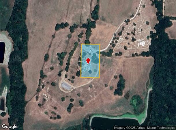
Property Record
1922 Bethel Cannon Rd, Whitewright, TX 75491
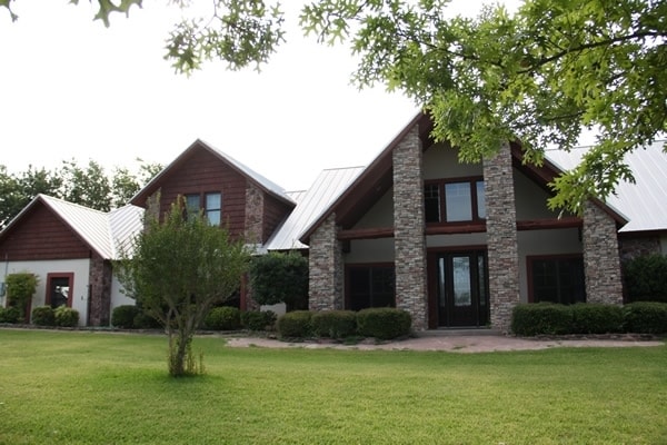
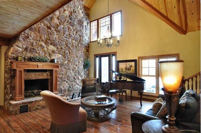
This Property Is For Sale
NEARBY LISTINGS FOR SALE OR LEASE
-
-
View all Whitewright listings for sale on LoopNet.com
Property Detail
1922 Bethel Cannon Rd
133155
Rutland James A-G1009
Commercialnec
G-1009 RUTLAND JAMES A-G1009, ACRES 1.809
X
Grayson
48147C0475C
Texas
2024
1.81 AC
2025
Texas East Area
001802
Other Market Areas
6,713 SF
Sherman-Denison, TX
DEMOGRAPHICS near 1922 Bethel Cannon Rd
1 Mile
3 Mile
5 Mile
2024 Total Population
209
1,362
4,577
2029 Population
233
1,518
5,108
Pop Growth 2024-2029
+ 11.48%
+ 11.45%
+ 11.60%
Average Age
42
42
41
2024 Total Households
79
513
1,715
HH Growth 2024-2029
+ 12.66%
+ 12.09%
+ 12.01%
Median Household Inc
$78,125
$79,250
$78,293
Avg Household Size
2.70
2.60
2.60
2024 Avg HH Vehicles
2.00
2.00
2.00
Median Home Value
$326,923
$317,262
$286,289
Median Year Built
1986
1987
1987
Nearby Places
Map Layers
Map Styles
 Street
 Aerial
- Restaurants
- Banks
- Shops
- Fitness
- Groceries
Nearby Properties
Address
Land Use
TOTAL SIZE
Lot Size
Zoning
Address
Land Use
TOTAL SIZE
Lot Size
Zoning
11,568 SF
17.66 AC
Address
Land Use
TOTAL SIZE
Lot Size
Zoning
30,251 SF
17 AC
Address
Land Use
TOTAL SIZE
Lot Size
Zoning
10,942 SF
95.64 AC
Address
Land Use
TOTAL SIZE
Lot Size
Zoning
107,715 SF
21.34 AC
Address
Land Use
TOTAL SIZE
Lot Size
Zoning
7,680 SF
20 AC
Address
Land Use
TOTAL SIZE
Lot Size
Zoning
11,508 SF
20 AC
Address
Land Use
TOTAL SIZE
Lot Size
Zoning
8,163 SF
30.15 AC
Address
Land Use
TOTAL SIZE
Lot Size
Zoning
5,679 SF
21.66 AC
Address
Land Use
TOTAL SIZE
Lot Size
Zoning
6,440 SF
46.20 AC
Address
Land Use
TOTAL SIZE
Lot Size
Zoning
9,251 SF
97.85 AC
Address
Land Use
TOTAL SIZE
Lot Size
Zoning
6,490 SF
13.43 AC
Address
Land Use
TOTAL SIZE
Lot Size
Zoning
6,617 SF
37.28 AC
Address
Land Use
TOTAL SIZE
Lot Size
Zoning
3,567 SF
37 AC
Address
Land Use
TOTAL SIZE
Lot Size
Zoning
6,675 SF
30.04 AC
Address
Land Use
TOTAL SIZE
Lot Size
Zoning
5,616 SF
29.98 AC
Address
Land Use
TOTAL SIZE
Lot Size
Zoning
17,010 SF
2 AC
Address
Land Use
TOTAL SIZE
Lot Size
Zoning
5,181 SF
19.20 AC
Address
Land Use
TOTAL SIZE
Lot Size
Zoning
3,895 SF
20 AC
Address
Land Use
TOTAL SIZE
Lot Size
Zoning
8,760 SF
4.13 AC
Address
Land Use
TOTAL SIZE
Lot Size
Zoning
3,472 SF
14.40 AC
Address
Land Use
TOTAL SIZE
Lot Size
Zoning
5,200 SF
80.76 AC
Address
Land Use
TOTAL SIZE
Lot Size
Zoning
3,535 SF
37.68 AC
Address
Land Use
TOTAL SIZE
Lot Size
Zoning
4,161 SF
20 AC
Address
Land Use
TOTAL SIZE
Lot Size
Zoning
4,205 SF
16 AC
Address
Land Use
TOTAL SIZE
Lot Size
Zoning
4,066 SF
25.25 AC
Address
Land Use
TOTAL SIZE
Lot Size
Zoning
5,029 SF
7.46 AC
Address
Land Use
TOTAL SIZE
Lot Size
Zoning
5,326 SF
25 AC
Address
Land Use
TOTAL SIZE
Lot Size
Zoning
3,200 SF
16.17 AC
Address
Land Use
TOTAL SIZE
Lot Size
Zoning
3,240 SF
13 AC
The World's #1 Commercial Real Estate Marketplace
Connect with us
© 2026 CoStar Group
The information above has been obtained from sources believed reliable. While we do not doubt its accuracy we have not verified it and make no guarantee, warranty or representation about it. It is your responsibility to independently confirm its accuracy and completeness. Any projections, opinions, assumptions, or estimates used are for example only and do not represent the current or future performance of the property. The value of this transaction to you depends on tax and other factors which should be evaluated by your tax, financial, and legal advisors. You and your advisors should conduct a careful, independent investigation of the property to determine to your satisfaction the suitability of the property for your needs.