Property Record
1922 Mackey Ferry Rd E, Mount Vernon, IN 47620
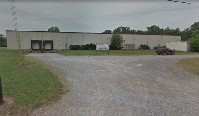


Property Detail
1922 Mackey Ferry Rd E
65-15-18-200-001.001-017
PT NE NW 18-7-13 5.00A
Manufacturinglight
POSEY
M2
Indiana
B and X Area of moderate flood hazard, usually the area between the limits of the 100-year and 500-year floods.
5 AC
2025
Posey County
2025
Evansville
040700
Evansville, IN
25,000 SF
NEARBY LISTINGS FOR SALE OR LEASE
-
-
View all Mount Vernon listings for lease on LoopNet.com
DEMOGRAPHICS near 1922 Mackey Ferry Rd E
1 mile
3 mile
5 mile
2025 Total Population
1,201
7,777
8,809
2030 Population
1,215
7,883
8,918
Pop Growth 2025-2030
+ 1.17%
+ 1.36%
+ 1.24%
Average Age
41
41
41
2025 Total Households
461
3,293
3,701
HH Growth 2025-2030
+ 1.30%
+ 1.31%
+ 1.22%
Median Household Inc
$82,908
$64,091
$67,618
Avg Household Size
2.30
2.30
2.30
2025 Avg HH Vehicles
2.00
2.00
2.00
Median Home Value
$236,324
$176,130
$187,603
Median Year Built
1974
1972
1972
Nearby Places
Map Layers
Map Styles
 Street
 Aerial
Layers
 Traffic
 Biking
Places
Listings with unknown addresses are not visible on the map
- Restaurants
- Banks
- Shops
- Fitness
- Groceries
PUBLIC TRANSPORTATION
AIRPORT
Evansville Regional
Drive
Walk
Distance
Evansville Regional
37 min
26.5 mi
SALE & LEASE HISTORY
LISTING DATE
SALE/LEASE

Oct 04, 2019
For Lease
May 14, 2018
For Sale
Nearby Properties
Address
Land Use
TOTAL SIZE
Lot Size
Zoning
Address
Land Use
TOTAL SIZE
Lot Size
Zoning
39,120 SF
Address
Land Use
TOTAL SIZE
Lot Size
Zoning
4,800 SF
99.67 AC
M2
Address
Land Use
TOTAL SIZE
Lot Size
Zoning
2,294 SF
925.89 AC
M2
Address
Land Use
TOTAL SIZE
Lot Size
Zoning
5,832 SF
Address
Land Use
TOTAL SIZE
Lot Size
Zoning
68,280 SF
50.44 AC
M2
Address
Land Use
TOTAL SIZE
Lot Size
Zoning
2,450 SF
60 AC
Address
Land Use
TOTAL SIZE
Lot Size
Zoning
123,168 SF
37.62 AC
M2
Address
Land Use
TOTAL SIZE
Lot Size
Zoning
36,560 SF
Address
Land Use
TOTAL SIZE
Lot Size
Zoning
21,704 SF
14.73 AC
M1
Address
Land Use
TOTAL SIZE
Lot Size
Zoning
4,180 SF
1.90 AC
Address
Land Use
TOTAL SIZE
Lot Size
Zoning
13,172 SF
4.93 AC
Address
Land Use
TOTAL SIZE
Lot Size
Zoning
59,400 SF
16.23 AC
Address
Land Use
TOTAL SIZE
Lot Size
Zoning
40,077 SF
6.35 AC
A
Address
Land Use
TOTAL SIZE
Lot Size
Zoning
5,562 SF
26.37 AC
M2
Address
Land Use
TOTAL SIZE
Lot Size
Zoning
1,600 SF
2.35 AC
Address
Land Use
TOTAL SIZE
Lot Size
Zoning
15,926 SF
54 AC
M2
Address
Land Use
TOTAL SIZE
Lot Size
Zoning
16,254 SF
1 AC
Address
Land Use
TOTAL SIZE
Lot Size
Zoning
120,000 SF
7.19 AC
M2
Address
Land Use
TOTAL SIZE
Lot Size
Zoning
120,000 SF
5.93 AC
Address
Land Use
TOTAL SIZE
Lot Size
Zoning
23,941 SF
0.24 AC
Address
Land Use
TOTAL SIZE
Lot Size
Zoning
96 SF
51.45 AC
M2
Address
Land Use
TOTAL SIZE
Lot Size
Zoning
13,092 SF
0.63 AC
Address
Land Use
TOTAL SIZE
Lot Size
Zoning
85,280 SF
6.36 AC
A
Address
Land Use
TOTAL SIZE
Lot Size
Zoning
29,039 SF
0.39 AC
Address
Land Use
TOTAL SIZE
Lot Size
Zoning
15,600 SF
0.92 AC
Address
Land Use
TOTAL SIZE
Lot Size
Zoning
2,071 SF
19.60 AC
M2
Address
Land Use
TOTAL SIZE
Lot Size
Zoning
3,000 SF
17.26 AC
M2
Address
Land Use
TOTAL SIZE
Lot Size
Zoning
23,718 SF
3.49 AC
B3
Address
Land Use
TOTAL SIZE
Lot Size
Zoning
13,807 SF
7.29 AC
R3
Address
Land Use
TOTAL SIZE
Lot Size
Zoning
1,469 SF
32.25 AC
M2
The World's #1 Commercial Real Estate Marketplace
Connect with us
© 2026 CoStar Group
The information above has been obtained from sources believed reliable. While we do not doubt its accuracy we have not verified it and make no guarantee, warranty or representation about it. It is your responsibility to independently confirm its accuracy and completeness. Any projections, opinions, assumptions, or estimates used are for example only and do not represent the current or future performance of the property. The value of this transaction to you depends on tax and other factors which should be evaluated by your tax, financial, and legal advisors. You and your advisors should conduct a careful, independent investigation of the property to determine to your satisfaction the suitability of the property for your needs.