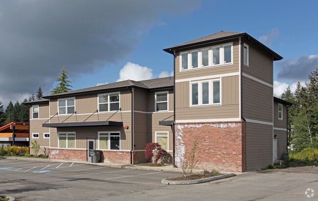
Property Record
1922 Pottery Ave, Port Orchard, WA 98366
NEARBY LISTINGS FOR SALE OR LEASE
Property Detail
1922 Pottery Ave
032301-1-015-2006
THAT PORTION OF THE NORTHEAST QUARTER OF THE NORTHEAST QUARTER OF SECTION 3, TOWNSHIP 23 NORTH, RANGE 1 EAST, W.M., IN KITSAP COUNTY, WASHINGTON, DESCRIBED AS FOLLOWS: BEGINNING AT A POINT 100 FEET SOUTH OF THE NORTHEAST CORNER OF THE NORTH 18 ACRES
Miscellaneous
Kitsap
X
Washington
53035C0369E
15
2025
0.38 AC
2026
Port Orchard
092200
Bremerton/Silverdale
1,289 SF
Bremerton-Silverdale, WA
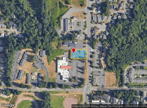
DEMOGRAPHICS near 1922 Pottery Ave
1 Mile
3 Mile
5 Mile
2024 Total Population
6,832
43,061
96,434
2029 Population
6,976
43,795
97,856
Pop Growth 2024-2029
+ 2.11%
+ 1.70%
+ 1.47%
Average Age
38
39
39
2024 Total Households
2,547
16,003
36,508
HH Growth 2024-2029
+ 2.04%
+ 1.74%
+ 1.65%
Median Household Inc
$51,351
$76,771
$71,531
Avg Household Size
2.50
2.50
2.40
2024 Avg HH Vehicles
2.00
2.00
2.00
Median Home Value
$361,923
$394,730
$409,774
Median Year Built
1984
1986
1980
Nearby Places
Map Layers
Map Styles
 Street
 Aerial
- Restaurants
- Banks
- Shops
- Fitness
- Groceries
PUBLIC TRANSPORTATION
AIRPORT
Seattle-Tacoma International
DRIVE
WALK
Distance
Seattle-Tacoma International
67 min
47.1 mi
Freight Ports
Port of Seattle
DRIVE
WALK
Distance
Port of Seattle
77 min
57.4 mi
SALE & LEASE HISTORY
LISTING DATE
SALE/LEASE

May 06, 2020
For Lease
Jun 21, 2019
For Sale
Nearby Properties
Address
Land Use
TOTAL SIZE
Lot Size
Zoning
Address
Land Use
TOTAL SIZE
Lot Size
Zoning
552 SF
17.39 AC
CITY
Address
Land Use
TOTAL SIZE
Lot Size
Zoning
143,022 SF
11.24 AC
R4
Address
Land Use
TOTAL SIZE
Lot Size
Zoning
127,853 SF
7.41 AC
R4
Address
Land Use
TOTAL SIZE
Lot Size
Zoning
135,371 SF
6.04 AC
R4
Address
Land Use
TOTAL SIZE
Lot Size
Zoning
112,847 SF
6.80 AC
UM
Address
Land Use
TOTAL SIZE
Lot Size
Zoning
17,592 SF
11.61 AC
UM
Address
Land Use
TOTAL SIZE
Lot Size
Zoning
25,973 SF
8.20 AC
CC
Address
Land Use
TOTAL SIZE
Lot Size
Zoning
110,994 SF
5.35 AC
R4
Address
Land Use
TOTAL SIZE
Lot Size
Zoning
1,092 SF
5.70 AC
CC
Address
Land Use
TOTAL SIZE
Lot Size
Zoning
125,582 SF
4.02 AC
NC
Address
Land Use
TOTAL SIZE
Lot Size
Zoning
0.54 AC
CITY
Address
Land Use
TOTAL SIZE
Lot Size
Zoning
110,778 SF
9.24 AC
CC
Address
Land Use
TOTAL SIZE
Lot Size
Zoning
158,870 SF
14.62 AC
CC
Address
Land Use
TOTAL SIZE
Lot Size
Zoning
185,893 SF
17.89 AC
CC
Address
Land Use
TOTAL SIZE
Lot Size
Zoning
77,580 SF
8.62 AC
UM
Address
Land Use
TOTAL SIZE
Lot Size
Zoning
14,660 SF
6.14 AC
UM
Address
Land Use
TOTAL SIZE
Lot Size
Zoning
14,660 SF
6.07 AC
UM
Address
Land Use
TOTAL SIZE
Lot Size
Zoning
49,604 SF
5.49 AC
UM
Address
Land Use
TOTAL SIZE
Lot Size
Zoning
62,642 SF
4.91 AC
UM
Address
Land Use
TOTAL SIZE
Lot Size
Zoning
56,006 SF
4.72 AC
UM
Address
Land Use
TOTAL SIZE
Lot Size
Zoning
73,931 SF
11.72 AC
FC
Address
Land Use
TOTAL SIZE
Lot Size
Zoning
45,379 SF
6.74 AC
UM
Address
Land Use
TOTAL SIZE
Lot Size
Zoning
69,192 SF
3.36 AC
UM
Address
Land Use
TOTAL SIZE
Lot Size
Zoning
2.33 AC
CITY
Address
Land Use
TOTAL SIZE
Lot Size
Zoning
55,866 SF
8.48 AC
FC
Address
Land Use
TOTAL SIZE
Lot Size
Zoning
138,087 SF
14.24 AC
CC
Address
Land Use
TOTAL SIZE
Lot Size
Zoning
68,708 SF
7.89 AC
PF
Address
Land Use
TOTAL SIZE
Lot Size
Zoning
520 SF
7.79 AC
C
Address
Land Use
TOTAL SIZE
Lot Size
Zoning
39,800 SF
4.69 AC
CC
Address
Land Use
TOTAL SIZE
Lot Size
Zoning
51,933 SF
4.07 AC
C
The World's #1 Commercial Real Estate Marketplace
Connect with us
© 2025 CoStar Group
The information above has been obtained from sources believed reliable. While we do not doubt its accuracy we have not verified it and make no guarantee, warranty or representation about it. It is your responsibility to independently confirm its accuracy and completeness. Any projections, opinions, assumptions, or estimates used are for example only and do not represent the current or future performance of the property. The value of this transaction to you depends on tax and other factors which should be evaluated by your tax, financial, and legal advisors. You and your advisors should conduct a careful, independent investigation of the property to determine to your satisfaction the suitability of the property for your needs.