Property Record
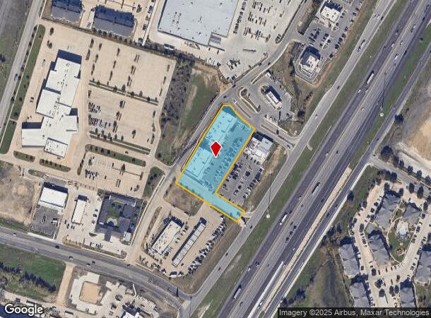
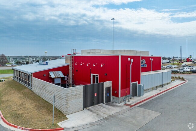
19230 Interstate 35, Kyle, TX 78640

NEARBY LISTINGS FOR SALE OR LEASE
Property Detail
19230 Interstate 35
Austin
Kyle Towne Center Second
Austin-Round Rock, TX
KYLE TOWNE CENTER SECOND, BLOCK A, LOT 15A, ACRES 2.148
R180409
Hays
Commercialnec
Texas
2024
15a
2025
2.15 AC
010913
Hays County
1,040 SF
DEMOGRAPHICS near 19230 Interstate 35
1 Mile
3 Mile
5 Mile
2024 Total Population
6,645
54,974
115,860
2029 Population
8,775
72,207
152,872
Pop Growth 2024-2029
+ 32.05%
+ 31.35%
+ 31.95%
Average Age
34
34
35
2024 Total Households
2,448
18,920
39,009
HH Growth 2024-2029
+ 33.05%
+ 32.41%
+ 33.06%
Median Household Inc
$63,490
$86,773
$90,664
Avg Household Size
2.70
2.90
2.90
2024 Avg HH Vehicles
2.00
2.00
2.00
Median Home Value
$255,436
$263,176
$281,246
Median Year Built
2009
2010
2010
Nearby Places
- Restaurants
- Banks
- Shops
- Fitness
- Groceries
PUBLIC TRANSPORTATION
AIRPORT
Austin-Bergstrom International
DRIVE
WALK
Distance
Austin-Bergstrom International
35 min
24.3 mi
SALE & LEASE HISTORY
LISTING DATE
SALE/LEASE

Sep 07, 2023
For Sale
Jun 11, 2024
For Sale
Nearby Properties
Address
Land Use
TOTAL SIZE
Lot Size
Zoning
Address
Land Use
TOTAL SIZE
Lot Size
Zoning
331,761 SF
57.23 AC
Address
Land Use
TOTAL SIZE
Lot Size
Zoning
364,569 SF
14.36 AC
Address
Land Use
TOTAL SIZE
Lot Size
Zoning
301,466 SF
21 AC
Address
Land Use
TOTAL SIZE
Lot Size
Zoning
319,545 SF
13.74 AC
Address
Land Use
TOTAL SIZE
Lot Size
Zoning
201,966 SF
33.54 AC
Address
Land Use
TOTAL SIZE
Lot Size
Zoning
332,150 SF
7.08 AC
Address
Land Use
TOTAL SIZE
Lot Size
Zoning
233,088 SF
12.36 AC
Address
Land Use
TOTAL SIZE
Lot Size
Zoning
421,200 SF
14.39 AC
Address
Land Use
TOTAL SIZE
Lot Size
Zoning
491,520 SF
38.84 AC
Address
Land Use
TOTAL SIZE
Lot Size
Zoning
737.01 AC
Address
Land Use
TOTAL SIZE
Lot Size
Zoning
383,970 SF
17.76 AC
Address
Land Use
TOTAL SIZE
Lot Size
Zoning
230,002 SF
6.07 AC
Address
Land Use
TOTAL SIZE
Lot Size
Zoning
403,635 SF
24.01 AC
Address
Land Use
TOTAL SIZE
Lot Size
Zoning
240,002 SF
53.46 AC
Address
Land Use
TOTAL SIZE
Lot Size
Zoning
347,316 SF
14 AC
Address
Land Use
TOTAL SIZE
Lot Size
Zoning
158,169 SF
14 AC
Address
Land Use
TOTAL SIZE
Lot Size
Zoning
240,168 SF
9.45 AC
Address
Land Use
TOTAL SIZE
Lot Size
Zoning
234,794 SF
10.07 AC
Address
Land Use
TOTAL SIZE
Lot Size
Zoning
193,470 SF
7.42 AC
Address
Land Use
TOTAL SIZE
Lot Size
Zoning
78,088 SF
7 AC
Address
Land Use
TOTAL SIZE
Lot Size
Zoning
125,488 SF
3.69 AC
Address
Land Use
TOTAL SIZE
Lot Size
Zoning
165,142 SF
12 AC
Address
Land Use
TOTAL SIZE
Lot Size
Zoning
144,088 SF
7.63 AC
Address
Land Use
TOTAL SIZE
Lot Size
Zoning
116,908 SF
3.58 AC
Address
Land Use
TOTAL SIZE
Lot Size
Zoning
Address
Land Use
TOTAL SIZE
Lot Size
Zoning
219,000 SF
15 AC
Address
Land Use
TOTAL SIZE
Lot Size
Zoning
64,836 SF
10 AC
Address
Land Use
TOTAL SIZE
Lot Size
Zoning
258,960 SF
18.31 AC
Address
Land Use
TOTAL SIZE
Lot Size
Zoning
62,202 SF
5.14 AC
Address
Land Use
TOTAL SIZE
Lot Size
Zoning
96.18 AC
The World's #1 Commercial Real Estate Marketplace
Connect with us
© 2025 CoStar Group
The information above has been obtained from sources believed reliable. While we do not doubt its accuracy we have not verified it and make no guarantee, warranty or representation about it. It is your responsibility to independently confirm its accuracy and completeness. Any projections, opinions, assumptions, or estimates used are for example only and do not represent the current or future performance of the property. The value of this transaction to you depends on tax and other factors which should be evaluated by your tax, financial, and legal advisors. You and your advisors should conduct a careful, independent investigation of the property to determine to your satisfaction the suitability of the property for your needs.