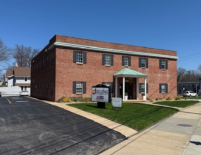
Property Record
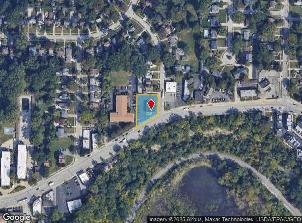
19220 Lorain Rd, Cleveland, OH 44126

Current Lease Availabilities
NEARBY LISTINGS FOR SALE OR LEASE
Property Detail
19220 Lorain Rd
Cleveland-Elyria, OH
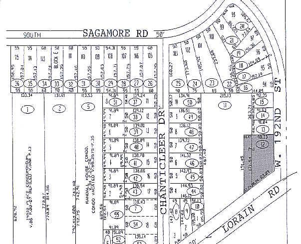
Rockport Sec 14
323-12-012
14 NEXT W OF W 192 ST
Medicalbuilding
Cuyahoga
X
Ohio
39035C0154E
14
2024
0.44 AC
2024
West
153107
Cleveland
6,900 SF
DEMOGRAPHICS near 19220 Lorain Rd
1 Mile
3 Mile
5 Mile
2024 Total Population
11,012
114,647
239,318
2029 Population
10,759
111,148
232,137
Pop Growth 2024-2029
(2.30%)
(3.05%)
(3.00%)
Average Age
44
41
41
2024 Total Households
5,564
52,306
108,769
HH Growth 2024-2029
(2.53%)
(3.27%)
(3.16%)
Median Household Inc
$60,721
$65,609
$59,038
Avg Household Size
1.90
2.10
2.10
2024 Avg HH Vehicles
1.00
2.00
2.00
Median Home Value
$230,455
$186,460
$175,298
Median Year Built
1961
1950
1953
Nearby Places
Map Layers
Map Styles
 Street
 Aerial
- Restaurants
- Banks
- Shops
- Fitness
- Groceries
PUBLIC TRANSPORTATION
AIRPORT
Cleveland-Hopkins International
DRIVE
WALK
Distance
Cleveland-Hopkins International
13 min
4.9 mi
Nearby Properties
Address
Land Use
TOTAL SIZE
Lot Size
Zoning
Address
Land Use
TOTAL SIZE
Lot Size
Zoning
263,090 SF
33.53 AC
GB-A
Address
Land Use
TOTAL SIZE
Lot Size
Zoning
780,869 SF
14.77 AC
LR
Address
Land Use
TOTAL SIZE
Lot Size
Zoning
318,724 SF
41.71 AC
EI
Address
Land Use
TOTAL SIZE
Lot Size
Zoning
657,013 SF
48.88 AC
SI
Address
Land Use
TOTAL SIZE
Lot Size
Zoning
187 SF
20.90 AC
PG
Address
Land Use
TOTAL SIZE
Lot Size
Zoning
89,195 SF
1.58 AC
1F-R1
Address
Land Use
TOTAL SIZE
Lot Size
Zoning
Address
Land Use
TOTAL SIZE
Lot Size
Zoning
518,244 SF
21.80 AC
Address
Land Use
TOTAL SIZE
Lot Size
Zoning
208,209 SF
12.10 AC
1F
Address
Land Use
TOTAL SIZE
Lot Size
Zoning
53,718 SF
2.19 AC
PF
Address
Land Use
TOTAL SIZE
Lot Size
Zoning
63,139 SF
1.52 AC
PF
Address
Land Use
TOTAL SIZE
Lot Size
Zoning
243,118 SF
15.01 AC
PF
Address
Land Use
TOTAL SIZE
Lot Size
Zoning
217,747 SF
29.07 AC
GB-A
Address
Land Use
TOTAL SIZE
Lot Size
Zoning
326,357 SF
6.40 AC
GB
Address
Land Use
TOTAL SIZE
Lot Size
Zoning
49.67 AC
SI
Address
Land Use
TOTAL SIZE
Lot Size
Zoning
355,242 SF
13.28 AC
RMF-HR
Address
Land Use
TOTAL SIZE
Lot Size
Zoning
162,449 SF
23.90 AC
PF
Address
Land Use
TOTAL SIZE
Lot Size
Zoning
25,814 SF
64.97 AC
2F
Address
Land Use
TOTAL SIZE
Lot Size
Zoning
90,324 SF
6.71 AC
GR
Address
Land Use
TOTAL SIZE
Lot Size
Zoning
235,984 SF
18.10 AC
GB
Address
Land Use
TOTAL SIZE
Lot Size
Zoning
103.89 AC
U5-A
Address
Land Use
TOTAL SIZE
Lot Size
Zoning
102,512 SF
5.17 AC
CR
Address
Land Use
TOTAL SIZE
Lot Size
Zoning
107,866 SF
11.22 AC
PF
Address
Land Use
TOTAL SIZE
Lot Size
Zoning
24.55 AC
GI
Address
Land Use
TOTAL SIZE
Lot Size
Zoning
244,602 SF
10.31 AC
CR
Address
Land Use
TOTAL SIZE
Lot Size
Zoning
142,740 SF
1.83 AC
MF-2
Address
Land Use
TOTAL SIZE
Lot Size
Zoning
20.99 AC
2F
Address
Land Use
TOTAL SIZE
Lot Size
Zoning
211,719 SF
18.82 AC
PF
Address
Land Use
TOTAL SIZE
Lot Size
Zoning
126,661 SF
7.07 AC
PD
Address
Land Use
TOTAL SIZE
Lot Size
Zoning
89,148 SF
52.94 AC
The World's #1 Commercial Real Estate Marketplace
Connect with us
© 2025 CoStar Group
The information above has been obtained from sources believed reliable. While we do not doubt its accuracy we have not verified it and make no guarantee, warranty or representation about it. It is your responsibility to independently confirm its accuracy and completeness. Any projections, opinions, assumptions, or estimates used are for example only and do not represent the current or future performance of the property. The value of this transaction to you depends on tax and other factors which should be evaluated by your tax, financial, and legal advisors. You and your advisors should conduct a careful, independent investigation of the property to determine to your satisfaction the suitability of the property for your needs.