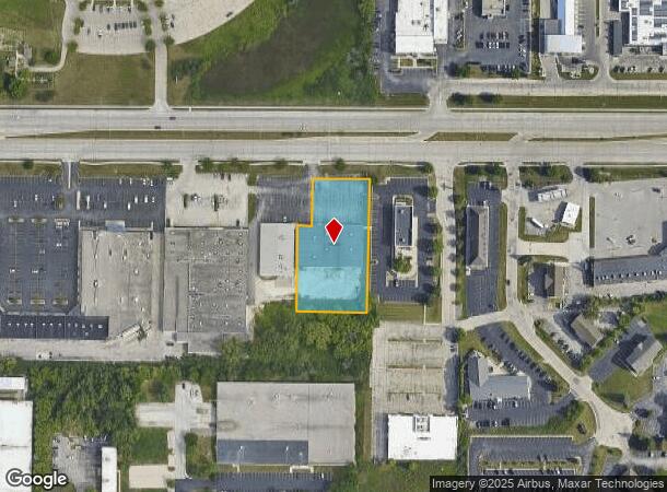
Property Record
19233 W Bluemound Rd, Brookfield, WI 53045
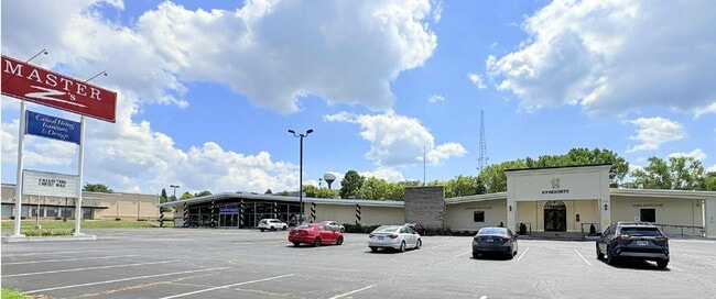
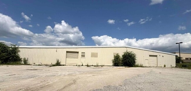
This Property Is For Sale
Current Lease Availabilities
NEARBY LISTINGS FOR SALE OR LEASE
Property Detail
19233 W Bluemound Rd
Milwaukee-Waukesha-West Allis, WI
Reciprocal Easement
BKFT-1124-996-008
LOT 1 CSM #4829 VOL 39/110 REC AS DOC #1317716 PT SE1/4 SEC 29 T7N R20E :: ALSO PT SE1/4 SEC 29 T7N R20E A PARCEL LYING W OF PARCEL 1 CSM #4974 & E OF PARCELS 1 & 3 CSM #4829 DESC AS: COM SE COR SE1/4; S883950W 1334.58 FT; N002028W 1021.53 FT THE BGN
Commercialnec
Waukesha
X
Wisconsin
55133C0217H
1
2024
1.43 AC
2024
Brookfield/New Berlin
201204
Milwaukee/Madison
DEMOGRAPHICS near 19233 W Bluemound Rd
1 Mile
3 Mile
5 Mile
2024 Total Population
5,973
44,425
135,086
2029 Population
6,310
46,652
140,196
Pop Growth 2024-2029
+ 5.64%
+ 5.01%
+ 3.78%
Average Age
45
43
43
2024 Total Households
2,685
18,795
56,906
HH Growth 2024-2029
+ 5.77%
+ 5.05%
+ 3.84%
Median Household Inc
$85,951
$88,392
$87,700
Avg Household Size
2.20
2.30
2.30
2024 Avg HH Vehicles
2.00
2.00
2.00
Median Home Value
$354,120
$363,555
$325,308
Median Year Built
1993
1984
1975
Nearby Places
- Restaurants
- Banks
- Shops
- Fitness
- Groceries
PUBLIC TRANSPORTATION
AIRPORT
General Mitchell International
DRIVE
WALK
Distance
General Mitchell International
33 min
18.7 mi
Freight Ports
Port Milwaukee
DRIVE
WALK
Distance
Port Milwaukee
26 min
15.9 mi
Nearby Properties
Address
Land Use
TOTAL SIZE
Lot Size
Zoning
Address
Land Use
TOTAL SIZE
Lot Size
Zoning
19.44 AC
Address
Land Use
TOTAL SIZE
Lot Size
Zoning
24.46 AC
Address
Land Use
TOTAL SIZE
Lot Size
Zoning
19.25 AC
Address
Land Use
TOTAL SIZE
Lot Size
Zoning
19.44 AC
Address
Land Use
TOTAL SIZE
Lot Size
Zoning
201,304 SF
29.43 AC
RM-2(PUD)
Address
Land Use
TOTAL SIZE
Lot Size
Zoning
12.50 AC
Address
Land Use
TOTAL SIZE
Lot Size
Zoning
20.02 AC
Address
Land Use
TOTAL SIZE
Lot Size
Zoning
Address
Land Use
TOTAL SIZE
Lot Size
Zoning
34.31 AC
Address
Land Use
TOTAL SIZE
Lot Size
Zoning
17.45 AC
Address
Land Use
TOTAL SIZE
Lot Size
Zoning
10.48 AC
Address
Land Use
TOTAL SIZE
Lot Size
Zoning
Address
Land Use
TOTAL SIZE
Lot Size
Zoning
7.20 AC
Address
Land Use
TOTAL SIZE
Lot Size
Zoning
Address
Land Use
TOTAL SIZE
Lot Size
Zoning
21.94 AC
Address
Land Use
TOTAL SIZE
Lot Size
Zoning
19.44 AC
Address
Land Use
TOTAL SIZE
Lot Size
Zoning
Address
Land Use
TOTAL SIZE
Lot Size
Zoning
Address
Land Use
TOTAL SIZE
Lot Size
Zoning
237,267 SF
16.14 AC
B-5
Address
Land Use
TOTAL SIZE
Lot Size
Zoning
3.55 AC
Address
Land Use
TOTAL SIZE
Lot Size
Zoning
167,693 SF
13.83 AC
B-5
Address
Land Use
TOTAL SIZE
Lot Size
Zoning
4.79 AC
Address
Land Use
TOTAL SIZE
Lot Size
Zoning
4.53 AC
Address
Land Use
TOTAL SIZE
Lot Size
Zoning
Address
Land Use
TOTAL SIZE
Lot Size
Zoning
Address
Land Use
TOTAL SIZE
Lot Size
Zoning
Address
Land Use
TOTAL SIZE
Lot Size
Zoning
11.34 AC
Address
Land Use
TOTAL SIZE
Lot Size
Zoning
Address
Land Use
TOTAL SIZE
Lot Size
Zoning
13.14 AC
Address
Land Use
TOTAL SIZE
Lot Size
Zoning
140,144 SF
13.85 AC
RM-2(PUD)
The World's #1 Commercial Real Estate Marketplace
Connect with us
© 2025 CoStar Group
The information above has been obtained from sources believed reliable. While we do not doubt its accuracy we have not verified it and make no guarantee, warranty or representation about it. It is your responsibility to independently confirm its accuracy and completeness. Any projections, opinions, assumptions, or estimates used are for example only and do not represent the current or future performance of the property. The value of this transaction to you depends on tax and other factors which should be evaluated by your tax, financial, and legal advisors. You and your advisors should conduct a careful, independent investigation of the property to determine to your satisfaction the suitability of the property for your needs.