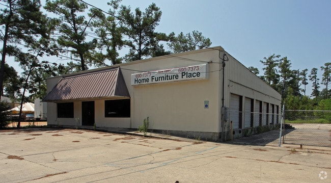
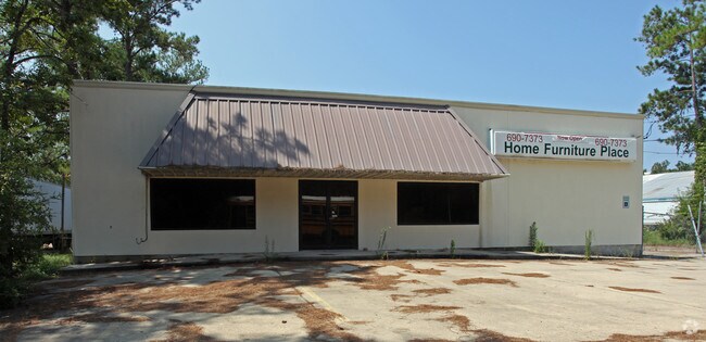
Property Record
1925 Gause Blvd W, Slidell, LA 70460

Property Detail
1925 Gause Blvd W
Slidell-Mandeville-Covington, LA
1.07 AC SEC 5 9 14
110029
ST TAMMANY
Commercialnec
Louisiana
2025
1.07 AC
2025
Slidell
041105
New Orleans/Metairie/Kenner
4,550 SF
NEARBY LISTINGS FOR SALE OR LEASE
DEMOGRAPHICS near 1925 Gause Blvd W
1 mile
3 mile
5 mile
2025 Total Population
4,603
31,416
77,221
2030 Population
4,730
32,334
79,542
Pop Growth 2025-2030
+ 2.76%
+ 2.92%
+ 3.01%
Average Age
40
40
40
2025 Total Households
1,722
12,264
29,690
HH Growth 2025-2030
+ 2.90%
+ 2.98%
+ 3.08%
Median Household Inc
$78,552
$63,172
$67,684
Avg Household Size
2.60
2.50
2.50
2025 Avg HH Vehicles
2.00
2.00
2.00
Median Home Value
$191,838
$192,059
$223,919
Median Year Built
1985
1980
1988
Nearby Places
Map Layers
Map Styles
 Street
 Aerial
Transit
 Traffic
 Biking
Places
Listings with unknown addresses are not visible on the map
- Restaurants
- Banks
- Shops
- Fitness
- Groceries
PUBLIC TRANSPORTATION
COMMUTER RAIL
Slidell Amtrak Station (Crescent - Amtrak)
Drive
Walk
Distance
Slidell Amtrak Station (Crescent - Amtrak)
3 min
2.5 mi
Freight Ports
Port of New Orleans
Drive
Walk
Distance
Port of New Orleans
51 min
37.6 mi
Nearby Properties
Address
Land Use
TOTAL SIZE
Lot Size
Zoning
Address
Land Use
TOTAL SIZE
Lot Size
Zoning
120,000 SF
6.75 AC
Address
Land Use
TOTAL SIZE
Lot Size
Zoning
205,496 SF
27.47 AC
Address
Land Use
TOTAL SIZE
Lot Size
Zoning
192,685 SF
Address
Land Use
TOTAL SIZE
Lot Size
Zoning
85,000 SF
12.23 AC
Address
Land Use
TOTAL SIZE
Lot Size
Zoning
208,769 SF
1 AC
Address
Land Use
TOTAL SIZE
Lot Size
Zoning
157,561 SF
10.06 AC
Address
Land Use
TOTAL SIZE
Lot Size
Zoning
137,402 SF
76.02 AC
Address
Land Use
TOTAL SIZE
Lot Size
Zoning
137,402 SF
52.77 AC
Address
Land Use
TOTAL SIZE
Lot Size
Zoning
144,638 SF
0.88 AC
Address
Land Use
TOTAL SIZE
Lot Size
Zoning
127,681 SF
3 AC
Address
Land Use
TOTAL SIZE
Lot Size
Zoning
67,517 SF
0.89 AC
Address
Land Use
TOTAL SIZE
Lot Size
Zoning
63,135 SF
12.49 AC
Address
Land Use
TOTAL SIZE
Lot Size
Zoning
105,633 SF
11 AC
Address
Land Use
TOTAL SIZE
Lot Size
Zoning
1,940 SF
1.77 AC
Address
Land Use
TOTAL SIZE
Lot Size
Zoning
54,188 SF
1.50 AC
Address
Land Use
TOTAL SIZE
Lot Size
Zoning
105,300 SF
8.75 AC
Address
Land Use
TOTAL SIZE
Lot Size
Zoning
131,548 SF
1 AC
Address
Land Use
TOTAL SIZE
Lot Size
Zoning
137,759 SF
1 AC
Address
Land Use
TOTAL SIZE
Lot Size
Zoning
108,003 SF
2.59 AC
Address
Land Use
TOTAL SIZE
Lot Size
Zoning
184,551 SF
20 AC
Address
Land Use
TOTAL SIZE
Lot Size
Zoning
80,737 SF
8.06 AC
Address
Land Use
TOTAL SIZE
Lot Size
Zoning
116,077 SF
9.14 AC
Address
Land Use
TOTAL SIZE
Lot Size
Zoning
115,776 SF
7.50 AC
Address
Land Use
TOTAL SIZE
Lot Size
Zoning
73,519 SF
6.97 AC
Address
Land Use
TOTAL SIZE
Lot Size
Zoning
114,806 SF
10.22 AC
Address
Land Use
TOTAL SIZE
Lot Size
Zoning
66,130 SF
3 AC
Address
Land Use
TOTAL SIZE
Lot Size
Zoning
66,634 SF
14 AC
Address
Land Use
TOTAL SIZE
Lot Size
Zoning
42,995 SF
5.20 AC
Address
Land Use
TOTAL SIZE
Lot Size
Zoning
1,378 SF
1.19 AC
Address
Land Use
TOTAL SIZE
Lot Size
Zoning
41,117 SF
5.63 AC
The World's #1 Commercial Real Estate Marketplace
Connect with us
© 2026 CoStar Group
The information above has been obtained from sources believed reliable. While we do not doubt its accuracy we have not verified it and make no guarantee, warranty or representation about it. It is your responsibility to independently confirm its accuracy and completeness. Any projections, opinions, assumptions, or estimates used are for example only and do not represent the current or future performance of the property. The value of this transaction to you depends on tax and other factors which should be evaluated by your tax, financial, and legal advisors. You and your advisors should conduct a careful, independent investigation of the property to determine to your satisfaction the suitability of the property for your needs.