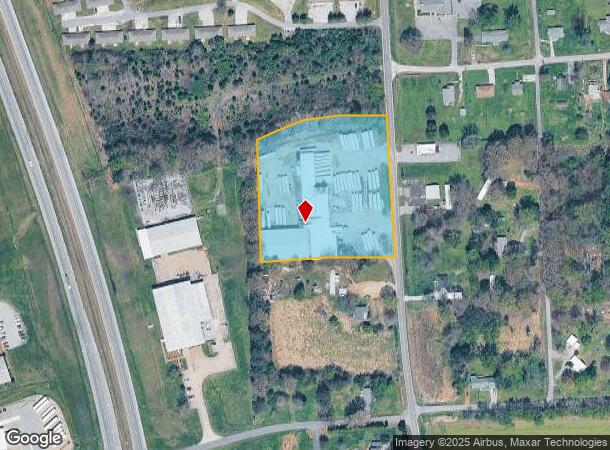
Property Record
1925 State Route 1241, Mayfield, KY 42066
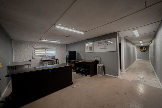

This Property Is For Sale
NEARBY LISTINGS FOR SALE OR LEASE
-
-
View all Mayfield listings for sale on LoopNet.com
Property Detail
1925 State Route 1241
086.00.00.098.00
BLDGS & 3.8 ACRES (86-26)
Commercialnec
Graves
X
Kentucky
21083C0150C
3.80 AC
2025
Kentucky West Area
2025
Other Market Areas
020301
Mayfield, KY
DEMOGRAPHICS near 1925 State Route 1241
1 Mile
3 Mile
5 Mile
2024 Total Population
425
1,889
6,442
2029 Population
432
1,914
6,516
Pop Growth 2024-2029
+ 1.65%
+ 1.32%
+ 1.15%
Average Age
42
42
41
2024 Total Households
177
783
2,599
HH Growth 2024-2029
+ 1.69%
+ 1.28%
+ 1.15%
Median Household Inc
$59,999
$60,123
$49,999
Avg Household Size
2.30
2.40
2.40
2024 Avg HH Vehicles
2.00
2.00
2.00
Median Home Value
$145,348
$151,396
$154,728
Median Year Built
1980
1981
1977
Nearby Places
Map Layers
Map Styles
 Street
 Aerial
- Restaurants
- Banks
- Shops
- Fitness
- Groceries
Nearby Properties
Address
Land Use
TOTAL SIZE
Lot Size
Zoning
Address
Land Use
TOTAL SIZE
Lot Size
Zoning
Address
Land Use
TOTAL SIZE
Lot Size
Zoning
47.40 AC
Address
Land Use
TOTAL SIZE
Lot Size
Zoning
34.38 AC
R
Address
Land Use
TOTAL SIZE
Lot Size
Zoning
100,000 SF
12.63 AC
R
Address
Land Use
TOTAL SIZE
Lot Size
Zoning
16,192 SF
14 AC
Address
Land Use
TOTAL SIZE
Lot Size
Zoning
10 AC
RESIDENTIA
Address
Land Use
TOTAL SIZE
Lot Size
Zoning
7.67 AC
R
Address
Land Use
TOTAL SIZE
Lot Size
Zoning
77.79 AC
R
Address
Land Use
TOTAL SIZE
Lot Size
Zoning
2,808 SF
8.74 AC
RESIDENTIA
Address
Land Use
TOTAL SIZE
Lot Size
Zoning
6.60 AC
R
Address
Land Use
TOTAL SIZE
Lot Size
Zoning
12.03 AC
R
Address
Land Use
TOTAL SIZE
Lot Size
Zoning
12,417 SF
10 AC
RESIDENTIA
Address
Land Use
TOTAL SIZE
Lot Size
Zoning
187.84 AC
R
Address
Land Use
TOTAL SIZE
Lot Size
Zoning
Address
Land Use
TOTAL SIZE
Lot Size
Zoning
1,800 SF
11.57 AC
R
Address
Land Use
TOTAL SIZE
Lot Size
Zoning
Address
Land Use
TOTAL SIZE
Lot Size
Zoning
14.50 AC
R
Address
Land Use
TOTAL SIZE
Lot Size
Zoning
Address
Land Use
TOTAL SIZE
Lot Size
Zoning
7,616 SF
3 AC
R
Address
Land Use
TOTAL SIZE
Lot Size
Zoning
63 AC
R
Address
Land Use
TOTAL SIZE
Lot Size
Zoning
8,000 SF
0.83 AC
R
Address
Land Use
TOTAL SIZE
Lot Size
Zoning
9.50 AC
Address
Land Use
TOTAL SIZE
Lot Size
Zoning
4,160 SF
2.14 AC
Address
Land Use
TOTAL SIZE
Lot Size
Zoning
74,400 SF
7.99 AC
Address
Land Use
TOTAL SIZE
Lot Size
Zoning
8,400 SF
1.59 AC
R
Address
Land Use
TOTAL SIZE
Lot Size
Zoning
9,600 SF
8.68 AC
RESIDENTIA
Address
Land Use
TOTAL SIZE
Lot Size
Zoning
2,302,403 SF
41.61 AC
R
Address
Land Use
TOTAL SIZE
Lot Size
Zoning
4,571 SF
2.60 AC
R
Address
Land Use
TOTAL SIZE
Lot Size
Zoning
15,000 SF
8 AC
R
Address
Land Use
TOTAL SIZE
Lot Size
Zoning
The World's #1 Commercial Real Estate Marketplace
Connect with us
© 2025 CoStar Group
The information above has been obtained from sources believed reliable. While we do not doubt its accuracy we have not verified it and make no guarantee, warranty or representation about it. It is your responsibility to independently confirm its accuracy and completeness. Any projections, opinions, assumptions, or estimates used are for example only and do not represent the current or future performance of the property. The value of this transaction to you depends on tax and other factors which should be evaluated by your tax, financial, and legal advisors. You and your advisors should conduct a careful, independent investigation of the property to determine to your satisfaction the suitability of the property for your needs.