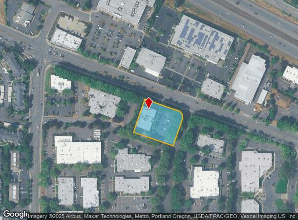
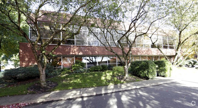
Property Record
1905 Nw 169Th Pl, Beaverton, OR 97006
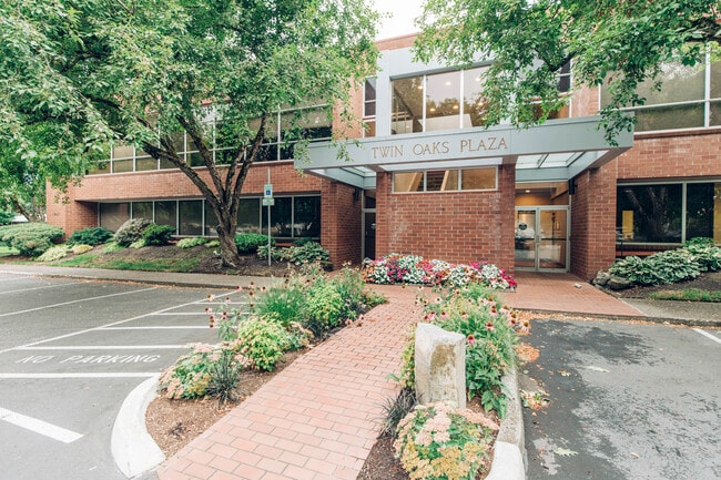
This Property Is For Sale
Current Lease Availabilities
NEARBY LISTINGS FOR SALE OR LEASE
Property Detail
1905 Nw 169Th Pl
Portland-Vancouver-Hillsboro, OR-WA
Quadrant Business Campus
R1295761
QUADRANT BUSINESS CAMPUS, LOT 7 & PT 8, ACRES 1.07
Commercialbuilding
Washington
X
Oregon
41067C0361E
7
2024
1.07 AC
2026
Sunset Corridor/Hillsboro
031621
Portland
27,515 SF
DEMOGRAPHICS near 1905 Nw 169Th Pl
1 Mile
3 Mile
5 Mile
2024 Total Population
16,761
157,222
298,286
2029 Population
16,733
158,406
300,431
Pop Growth 2024-2029
(0.17%)
+ 0.75%
+ 0.72%
Average Age
39
37
38
2024 Total Households
6,519
60,668
114,195
HH Growth 2024-2029
(0.15%)
+ 0.70%
+ 0.73%
Median Household Inc
$93,486
$100,821
$96,784
Avg Household Size
2.50
2.50
2.50
2024 Avg HH Vehicles
2.00
2.00
2.00
Median Home Value
$528,307
$534,163
$514,253
Median Year Built
1988
1995
1992
Nearby Places
Map Layers
Map Styles
 Street
 Aerial
- Restaurants
- Banks
- Shops
- Fitness
- Groceries
PUBLIC TRANSPORTATION
COMMUTER RAIL
Beaverton Transit Center (West Side Express) (Westside Express Service - Tri-County Metropolitan Transportation District of Oregon Rail (TriMet Rail))
DRIVE
WALK
Distance
Beaverton Transit Center (West Side Express) (Westside Express Service - Tri-County Metropolitan Transportation District of Oregon Rail (TriMet Rail))
10 min
6.1 mi
Hall/Nimbus (Westside Express Service - Tri-County Metropolitan Transportation District of Oregon Rail (TriMet Rail))
DRIVE
WALK
Distance
Hall/Nimbus (Westside Express Service - Tri-County Metropolitan Transportation District of Oregon Rail (TriMet Rail))
10 min
7.9 mi
AIRPORT
Portland International
DRIVE
WALK
Distance
Portland International
29 min
22.7 mi
Freight Ports
Port of Portland
DRIVE
WALK
Distance
Port of Portland
1 min
7.3 mi
Nearby Properties
Address
Land Use
TOTAL SIZE
Lot Size
Zoning
Address
Land Use
TOTAL SIZE
Lot Size
Zoning
0.05 AC
IND
Address
Land Use
TOTAL SIZE
Lot Size
Zoning
2,936,291 SF
72.49 AC
TO:EMP
Address
Land Use
TOTAL SIZE
Lot Size
Zoning
562,350 SF
203.06 AC
INST
Address
Land Use
TOTAL SIZE
Lot Size
Zoning
58.68 AC
IND
Address
Land Use
TOTAL SIZE
Lot Size
Zoning
373,884 SF
153.56 AC
UC-RP
Address
Land Use
TOTAL SIZE
Lot Size
Zoning
1,004,655 SF
24.55 AC
SCR-V
Address
Land Use
TOTAL SIZE
Lot Size
Zoning
716,311 SF
75.07 AC
TO:EMP
Address
Land Use
TOTAL SIZE
Lot Size
Zoning
194.52 AC
R1
Address
Land Use
TOTAL SIZE
Lot Size
Zoning
0.03 AC
I-P
Address
Land Use
TOTAL SIZE
Lot Size
Zoning
1,031,421 SF
22.20 AC
SC-HDR
Address
Land Use
TOTAL SIZE
Lot Size
Zoning
316,321 SF
0.11 AC
I-P
Address
Land Use
TOTAL SIZE
Lot Size
Zoning
704,877 SF
18.72 AC
OI-NC
Address
Land Use
TOTAL SIZE
Lot Size
Zoning
791,581 SF
22.58 AC
MFR-3
Address
Land Use
TOTAL SIZE
Lot Size
Zoning
281,695 SF
7.41 AC
SC-HDR
Address
Land Use
TOTAL SIZE
Lot Size
Zoning
482,173 SF
14.99 AC
C-G
Address
Land Use
TOTAL SIZE
Lot Size
Zoning
44.66 AC
IND
Address
Land Use
TOTAL SIZE
Lot Size
Zoning
281,183 SF
44.96 AC
R-5
Address
Land Use
TOTAL SIZE
Lot Size
Zoning
152,339 SF
28.70 AC
R1
Address
Land Use
TOTAL SIZE
Lot Size
Zoning
253,727 SF
38.06 AC
OI
Address
Land Use
TOTAL SIZE
Lot Size
Zoning
120,400 SF
16.28 AC
TC-HDR
Address
Land Use
TOTAL SIZE
Lot Size
Zoning
22.13 AC
R-15
Address
Land Use
TOTAL SIZE
Lot Size
Zoning
495,454 SF
16.99 AC
SCR-V
Address
Land Use
TOTAL SIZE
Lot Size
Zoning
409,887 SF
20.03 AC
MFR-3
Address
Land Use
TOTAL SIZE
Lot Size
Zoning
71.43 AC
I-P
Address
Land Use
TOTAL SIZE
Lot Size
Zoning
210,649 SF
15.51 AC
R-15
Address
Land Use
TOTAL SIZE
Lot Size
Zoning
834,910 SF
14.87 AC
C-G
Address
Land Use
TOTAL SIZE
Lot Size
Zoning
324,326 SF
4.23 AC
SCC-SC
Address
Land Use
TOTAL SIZE
Lot Size
Zoning
360,916 SF
18.60 AC
MFR-2
Address
Land Use
TOTAL SIZE
Lot Size
Zoning
18.15 AC
SC-E
Address
Land Use
TOTAL SIZE
Lot Size
Zoning
373,552 SF
13.19 AC
MFR-3
The World's #1 Commercial Real Estate Marketplace
Connect with us
© 2026 CoStar Group
The information above has been obtained from sources believed reliable. While we do not doubt its accuracy we have not verified it and make no guarantee, warranty or representation about it. It is your responsibility to independently confirm its accuracy and completeness. Any projections, opinions, assumptions, or estimates used are for example only and do not represent the current or future performance of the property. The value of this transaction to you depends on tax and other factors which should be evaluated by your tax, financial, and legal advisors. You and your advisors should conduct a careful, independent investigation of the property to determine to your satisfaction the suitability of the property for your needs.