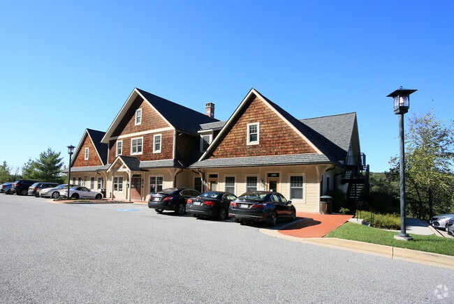
Property Record
10404 Stevenson Rd, Stevenson, MD 21153

Current Lease Availabilities
Property Detail
10404 Stevenson Rd
03-2500003153
4.076AC
Officebuilding
Baltimore
BL
Maryland
B and X Area of moderate flood hazard, usually the area between the limits of the 100-year and 500-year floods.
4.08 AC
2024
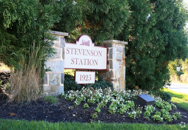
Reisterstown Rd Corridor
2025
Baltimore
403802
Baltimore-Columbia-Towson, MD
25,467 SF
NEARBY LISTINGS FOR SALE OR LEASE
DEMOGRAPHICS near 10404 Stevenson Rd
1 mile
3 mile
5 mile
2025 Total Population
1,904
42,227
203,119
2030 Population
1,908
42,301
202,039
Pop Growth 2025-2030
+ 0.21%
+ 0.18%
(0.53%)
Average Age
46
43
42
2025 Total Households
710
17,222
81,930
HH Growth 2025-2030
+ 0.14%
+ 0.20%
(0.56%)
Median Household Inc
$229,398
$107,200
$88,709
Avg Household Size
2.70
2.40
2.40
2025 Avg HH Vehicles
2.00
2.00
2.00
Median Home Value
$811,424
$468,355
$378,068
Median Year Built
1967
1980
1974
Nearby Places
Map Layers
Map Styles
 Street
 Aerial
Transit
 Traffic
 Biking
Places
Listings with unknown addresses are not visible on the map
- Restaurants
- Banks
- Shops
- Fitness
- Groceries
PUBLIC TRANSPORTATION
AIRPORT
Baltimore/Washington International Thurgood Marshall
Drive
Walk
Distance
Baltimore/Washington International Thurgood Marshall
33 min
19.4 mi
Freight Ports
Port of Baltimore
Drive
Walk
Distance
Port of Baltimore
25 min
13.0 mi
Nearby Properties
Address
Land Use
TOTAL SIZE
Lot Size
Zoning
Address
Land Use
TOTAL SIZE
Lot Size
Zoning
408,321 SF
39.16 AC
BM
Address
Land Use
TOTAL SIZE
Lot Size
Zoning
569,200 SF
8.82 AC
BM
Address
Land Use
TOTAL SIZE
Lot Size
Zoning
23.07 AC
DR16
Address
Land Use
TOTAL SIZE
Lot Size
Zoning
Address
Land Use
TOTAL SIZE
Lot Size
Zoning
178,200 SF
5.58 AC
BR-CR
Address
Land Use
TOTAL SIZE
Lot Size
Zoning
99,153 SF
9.41 AC
OR2
Address
Land Use
TOTAL SIZE
Lot Size
Zoning
Address
Land Use
TOTAL SIZE
Lot Size
Zoning
7.05 AC
BM
Address
Land Use
TOTAL SIZE
Lot Size
Zoning
186,708 SF
10.92 AC
DR3.5
Address
Land Use
TOTAL SIZE
Lot Size
Zoning
73,186 SF
34 AC
Address
Land Use
TOTAL SIZE
Lot Size
Zoning
6.14 AC
02
Address
Land Use
TOTAL SIZE
Lot Size
Zoning
145,800 SF
44 SF
Address
Land Use
TOTAL SIZE
Lot Size
Zoning
190,243 SF
3.28 AC
R-9
Address
Land Use
TOTAL SIZE
Lot Size
Zoning
8.76 AC
RAE1
Address
Land Use
TOTAL SIZE
Lot Size
Zoning
279,000 SF
21.85 AC
BM
Address
Land Use
TOTAL SIZE
Lot Size
Zoning
29.54 AC
BM
Address
Land Use
TOTAL SIZE
Lot Size
Zoning
2,993 SF
11.36 AC
BL
Address
Land Use
TOTAL SIZE
Lot Size
Zoning
9,573 SF
10.52 AC
BM
Address
Land Use
TOTAL SIZE
Lot Size
Zoning
338,824 SF
5.13 AC
Address
Land Use
TOTAL SIZE
Lot Size
Zoning
125,946 SF
32.20 AC
DR3.5
Address
Land Use
TOTAL SIZE
Lot Size
Zoning
13.86 AC
Address
Land Use
TOTAL SIZE
Lot Size
Zoning
126,168 SF
10.07 AC
Address
Land Use
TOTAL SIZE
Lot Size
Zoning
Address
Land Use
TOTAL SIZE
Lot Size
Zoning
111,997 SF
9.18 AC
DR2
Address
Land Use
TOTAL SIZE
Lot Size
Zoning
91,000 SF
15 AC
DR2
Address
Land Use
TOTAL SIZE
Lot Size
Zoning
8.49 AC
OR2
Address
Land Use
TOTAL SIZE
Lot Size
Zoning
92,600 SF
21.41 AC
DR2
Address
Land Use
TOTAL SIZE
Lot Size
Zoning
9.54 AC
BR
Address
Land Use
TOTAL SIZE
Lot Size
Zoning
102,840 SF
9.10 AC
O3
Address
Land Use
TOTAL SIZE
Lot Size
Zoning
75,000 SF
8.70 AC
BL
The World's #1 Commercial Real Estate Marketplace
Connect with us
© 2026 CoStar Group
The information above has been obtained from sources believed reliable. While we do not doubt its accuracy we have not verified it and make no guarantee, warranty or representation about it. It is your responsibility to independently confirm its accuracy and completeness. Any projections, opinions, assumptions, or estimates used are for example only and do not represent the current or future performance of the property. The value of this transaction to you depends on tax and other factors which should be evaluated by your tax, financial, and legal advisors. You and your advisors should conduct a careful, independent investigation of the property to determine to your satisfaction the suitability of the property for your needs.