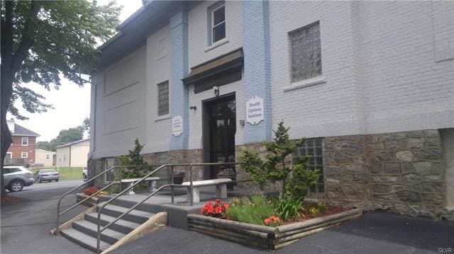
Property Record
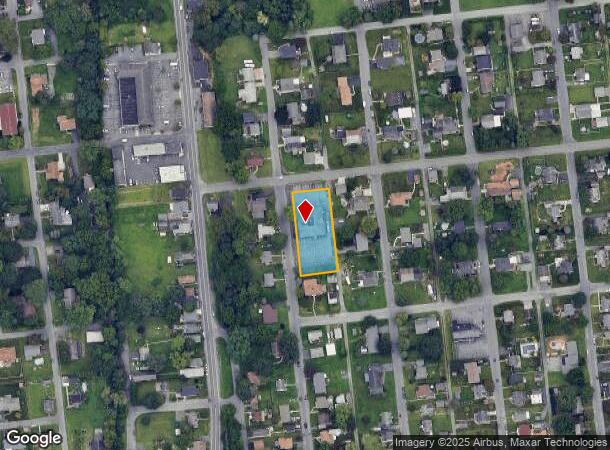
1926 2Nd St, Bethlehem, PA 18020
NEARBY LISTINGS FOR SALE OR LEASE
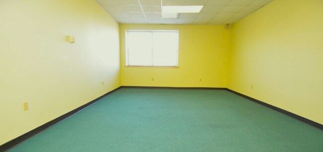
Property Detail
1926 2Nd St
N7NW3 44 9 0205
Map Of Miller Heights
Officebuilding
Northampton
X
Pennsylvania
42095C0264E
0.63 AC
2025
Lehigh Valley
2025
Philadelphia
017603
Allentown-Bethlehem-Easton, PA-NJ
10,668 SF
DEMOGRAPHICS near 1926 2Nd St
1 Mile
3 Mile
5 Mile
2024 Total Population
11,194
67,634
156,825
2029 Population
11,256
67,886
157,534
Pop Growth 2024-2029
+ 0.55%
+ 0.37%
+ 0.45%
Average Age
43
42
41
2024 Total Households
4,421
26,528
61,053
HH Growth 2024-2029
+ 0.61%
+ 0.36%
+ 0.52%
Median Household Inc
$85,642
$80,876
$75,858
Avg Household Size
2.50
2.40
2.40
2024 Avg HH Vehicles
2.00
2.00
2.00
Median Home Value
$246,129
$253,074
$257,841
Median Year Built
1968
1968
1966
Nearby Places
Map Layers
Map Styles
 Street
 Aerial
- Restaurants
- Banks
- Shops
- Fitness
- Groceries
PUBLIC TRANSPORTATION
AIRPORT
Lehigh Valley International
DRIVE
WALK
Distance
Lehigh Valley International
17 min
8.3 mi
Freight Ports
Port of Philadelphia
DRIVE
WALK
Distance
Port of Philadelphia
92 min
55.4 mi
SALE & LEASE HISTORY
LISTING DATE
SALE/LEASE

May 18, 2023
For Lease
May 18, 2023
For Sale
Jun 26, 2018
For Sale
Dec 06, 2018
For Sale
Apr 25, 2023
For Sale
Nearby Properties
Address
Land Use
TOTAL SIZE
Lot Size
Zoning
Address
Land Use
TOTAL SIZE
Lot Size
Zoning
425,507 SF
52.58 AC
HI
Address
Land Use
TOTAL SIZE
Lot Size
Zoning
1,197,396 SF
57.03 AC
HI
Address
Land Use
TOTAL SIZE
Lot Size
Zoning
1,200,000 SF
107.27 AC
HI
Address
Land Use
TOTAL SIZE
Lot Size
Zoning
1,710,800 SF
68.08 AC
HI
Address
Land Use
TOTAL SIZE
Lot Size
Zoning
148,804 SF
22.75 AC
OB
Address
Land Use
TOTAL SIZE
Lot Size
Zoning
26,653 SF
13.51 AC
HI
Address
Land Use
TOTAL SIZE
Lot Size
Zoning
800,280 SF
18.20 AC
HI
Address
Land Use
TOTAL SIZE
Lot Size
Zoning
332,641 SF
2.27 AC
HI
Address
Land Use
TOTAL SIZE
Lot Size
Zoning
52,164 SF
124.81 AC
IN
Address
Land Use
TOTAL SIZE
Lot Size
Zoning
800,250 SF
40.07 AC
HI
Address
Land Use
TOTAL SIZE
Lot Size
Zoning
676,788 SF
39.39 AC
HI
Address
Land Use
TOTAL SIZE
Lot Size
Zoning
3,400 SF
65.07 AC
RM
Address
Land Use
TOTAL SIZE
Lot Size
Zoning
524,948 SF
35.66 AC
LI
Address
Land Use
TOTAL SIZE
Lot Size
Zoning
421,883 SF
34.66 AC
HI
Address
Land Use
TOTAL SIZE
Lot Size
Zoning
347,514 SF
10.27 AC
RM
Address
Land Use
TOTAL SIZE
Lot Size
Zoning
168,984 SF
20.31 AC
I
Address
Land Use
TOTAL SIZE
Lot Size
Zoning
249,872 SF
41.83 AC
PC
Address
Land Use
TOTAL SIZE
Lot Size
Zoning
56,276 SF
14.91 AC
RR
Address
Land Use
TOTAL SIZE
Lot Size
Zoning
319,788 SF
60 AC
IN
Address
Land Use
TOTAL SIZE
Lot Size
Zoning
512,902 SF
35.18 AC
LI
Address
Land Use
TOTAL SIZE
Lot Size
Zoning
63,711 SF
31.56 AC
RR
Address
Land Use
TOTAL SIZE
Lot Size
Zoning
42,465 SF
7.28 AC
LI
Address
Land Use
TOTAL SIZE
Lot Size
Zoning
539,133 SF
47 AC
LI
Address
Land Use
TOTAL SIZE
Lot Size
Zoning
809,830 SF
25.68 AC
HI
Address
Land Use
TOTAL SIZE
Lot Size
Zoning
809,830 SF
21.93 AC
HI
Address
Land Use
TOTAL SIZE
Lot Size
Zoning
20,000 SF
2.81 AC
HI
Address
Land Use
TOTAL SIZE
Lot Size
Zoning
536,726 SF
12.02 AC
HI
Address
Land Use
TOTAL SIZE
Lot Size
Zoning
208,053 SF
45.58 AC
I
Address
Land Use
TOTAL SIZE
Lot Size
Zoning
508,842 SF
26.64 AC
HI
Address
Land Use
TOTAL SIZE
Lot Size
Zoning
257,186 SF
14.63 AC
G1
The World's #1 Commercial Real Estate Marketplace
Connect with us
© 2025 CoStar Group
The information above has been obtained from sources believed reliable. While we do not doubt its accuracy we have not verified it and make no guarantee, warranty or representation about it. It is your responsibility to independently confirm its accuracy and completeness. Any projections, opinions, assumptions, or estimates used are for example only and do not represent the current or future performance of the property. The value of this transaction to you depends on tax and other factors which should be evaluated by your tax, financial, and legal advisors. You and your advisors should conduct a careful, independent investigation of the property to determine to your satisfaction the suitability of the property for your needs.