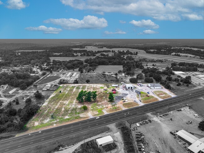
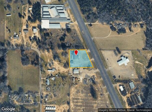
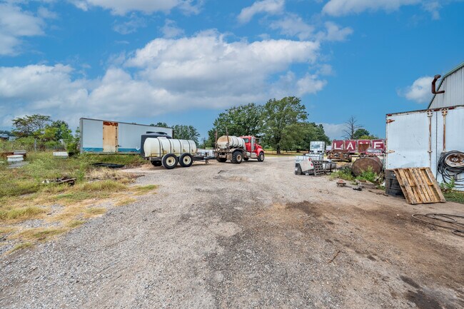
Property Record
19265 Us Highway 69 N, Lindale, TX 75771
NEARBY LISTINGS FOR SALE OR LEASE
-
-
View all Lindale listings for sale on LoopNet.com
Property Detail
19265 Us Highway 69 N
1-00000-0930-00-013000
A0930 W Shamblin
Warehouse
ABST A0930 W SHAMBLINTRACT 13
X
Smith
48499C0450C
Texas
2024
1.48 AC
2025
Tyler & Longview
001404
Other Market Areas
5,360 SF
Tyler, TX
DEMOGRAPHICS near 19265 Us Highway 69 N
1 Mile
3 Mile
5 Mile
2024 Total Population
588
8,953
19,054
2029 Population
640
9,738
20,792
Pop Growth 2024-2029
+ 8.84%
+ 8.77%
+ 9.12%
Average Age
38
39
41
2024 Total Households
209
3,224
7,019
HH Growth 2024-2029
+ 8.13%
+ 8.25%
+ 8.61%
Median Household Inc
$68,666
$75,888
$76,595
Avg Household Size
2.70
2.70
2.60
2024 Avg HH Vehicles
2.00
2.00
2.00
Median Home Value
$192,187
$223,770
$233,114
Median Year Built
2005
1996
1994
Nearby Places
Map Layers
Map Styles
 Street
 Aerial
- Restaurants
- Banks
- Shops
- Fitness
- Groceries
PUBLIC TRANSPORTATION
COMMUTER RAIL
Mineola (Texas Eagle - Amtrak)
DRIVE
WALK
Distance
Mineola (Texas Eagle - Amtrak)
11 min
9.5 mi
AIRPORT
Tyler Pounds Regional
DRIVE
WALK
Distance
Tyler Pounds Regional
22 min
16.6 mi
Freight Ports
Port of Shreveport
DRIVE
WALK
Distance
Port of Shreveport
127 min
114.7 mi
SALE & LEASE HISTORY
LISTING DATE
SALE/LEASE

Oct 11, 2024
For Sale
Nearby Properties
Address
Land Use
TOTAL SIZE
Lot Size
Zoning
Address
Land Use
TOTAL SIZE
Lot Size
Zoning
74,983 SF
5.44 AC
Address
Land Use
TOTAL SIZE
Lot Size
Zoning
13,776 SF
3.64 AC
Address
Land Use
TOTAL SIZE
Lot Size
Zoning
44,616 SF
3.30 AC
Address
Land Use
TOTAL SIZE
Lot Size
Zoning
44,299 SF
9.36 AC
Address
Land Use
TOTAL SIZE
Lot Size
Zoning
26.50 AC
Address
Land Use
TOTAL SIZE
Lot Size
Zoning
66,065 SF
2.56 AC
Address
Land Use
TOTAL SIZE
Lot Size
Zoning
19.02 AC
Address
Land Use
TOTAL SIZE
Lot Size
Zoning
3,063 SF
0.27 AC
Address
Land Use
TOTAL SIZE
Lot Size
Zoning
29,024 SF
1.27 AC
Address
Land Use
TOTAL SIZE
Lot Size
Zoning
5.75 AC
Address
Land Use
TOTAL SIZE
Lot Size
Zoning
59,382 SF
3.21 AC
Address
Land Use
TOTAL SIZE
Lot Size
Zoning
32,107 SF
5.53 AC
Address
Land Use
TOTAL SIZE
Lot Size
Zoning
35,870 SF
3.19 AC
Address
Land Use
TOTAL SIZE
Lot Size
Zoning
4.68 AC
Address
Land Use
TOTAL SIZE
Lot Size
Zoning
10,000 SF
1 AC
Address
Land Use
TOTAL SIZE
Lot Size
Zoning
6,981 SF
1.68 AC
Address
Land Use
TOTAL SIZE
Lot Size
Zoning
1,988 SF
3.04 AC
Address
Land Use
TOTAL SIZE
Lot Size
Zoning
15,419 SF
0.54 AC
Address
Land Use
TOTAL SIZE
Lot Size
Zoning
15,232 SF
4.37 AC
Address
Land Use
TOTAL SIZE
Lot Size
Zoning
44,147 SF
Address
Land Use
TOTAL SIZE
Lot Size
Zoning
22,770 SF
3.45 AC
Address
Land Use
TOTAL SIZE
Lot Size
Zoning
117.45 AC
Address
Land Use
TOTAL SIZE
Lot Size
Zoning
Address
Land Use
TOTAL SIZE
Lot Size
Zoning
11,200 SF
42.75 AC
Address
Land Use
TOTAL SIZE
Lot Size
Zoning
3,928 SF
1.20 AC
Address
Land Use
TOTAL SIZE
Lot Size
Zoning
14,260 SF
5.39 AC
Address
Land Use
TOTAL SIZE
Lot Size
Zoning
13,118 SF
0.64 AC
Address
Land Use
TOTAL SIZE
Lot Size
Zoning
8,560 SF
0.54 AC
Address
Land Use
TOTAL SIZE
Lot Size
Zoning
8,800 SF
0.95 AC
Address
Land Use
TOTAL SIZE
Lot Size
Zoning
10,556 SF
0.31 AC
The World's #1 Commercial Real Estate Marketplace
Connect with us
© 2025 CoStar Group
The information above has been obtained from sources believed reliable. While we do not doubt its accuracy we have not verified it and make no guarantee, warranty or representation about it. It is your responsibility to independently confirm its accuracy and completeness. Any projections, opinions, assumptions, or estimates used are for example only and do not represent the current or future performance of the property. The value of this transaction to you depends on tax and other factors which should be evaluated by your tax, financial, and legal advisors. You and your advisors should conduct a careful, independent investigation of the property to determine to your satisfaction the suitability of the property for your needs.