Property Record
1910 Kings Hwy, Punta Gorda, FL 33980
NEARBY LISTINGS FOR SALE OR LEASE
Property Detail
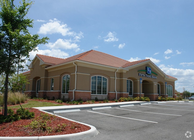
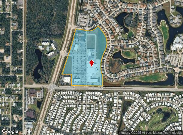
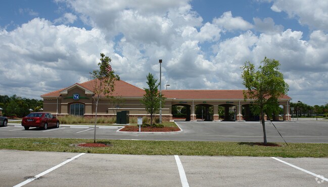
1910 Kings Hwy
402307376002
Intxn Of Sw Cor Kingsgate
Regionalshoppingcenterormallwithanchorstore
07 40 23 P1-1-1 & P1-1-9 23.44 AC M/L BEG AT SW COR TRACT B OF KINGS GATE TH N 245.30 TO ARC TO RIGHT TH NELY ALONG ARC 104.51 FT TO COMPOUND CURVE TH NELY ALNG ARC 469.71 FT TO REVERSE CURVE TO LEFT TH NWLY ALONG ARC 470.98 FT TH NW 182.72 FT TH SW
X
Charlotte
12015C0068G
Florida
2024
23.44 AC
2025
Charlotte County
020104
Southwest Florida
154,304 SF
Punta Gorda, FL
DEMOGRAPHICS near 1910 Kings Hwy
1 Mile
3 Mile
5 Mile
2024 Total Population
6,775
50,011
85,890
2029 Population
8,238
59,525
102,227
Pop Growth 2024-2029
+ 21.59%
+ 19.02%
+ 19.02%
Average Age
59
51
50
2024 Total Households
3,422
22,483
38,428
HH Growth 2024-2029
+ 22.09%
+ 19.42%
+ 19.41%
Median Household Inc
$63,675
$57,009
$55,356
Avg Household Size
1.90
2.20
2.20
2024 Avg HH Vehicles
2.00
2.00
2.00
Median Home Value
$191,079
$221,593
$219,908
Median Year Built
2000
1988
1986
Nearby Places
- Restaurants
- Banks
- Shops
- Fitness
- Groceries
PUBLIC TRANSPORTATION
AIRPORT
Punta Gorda
DRIVE
WALK
Distance
Punta Gorda
17 min
10.7 mi
Freight Ports
Port Manatee
DRIVE
WALK
Distance
Port Manatee
78 min
65.6 mi
Nearby Properties
Address
Land Use
TOTAL SIZE
Lot Size
Zoning
Address
Land Use
TOTAL SIZE
Lot Size
Zoning
202,009 SF
20.89 AC
PD
Address
Land Use
TOTAL SIZE
Lot Size
Zoning
129,475 SF
16.04 AC
OMI
Address
Land Use
TOTAL SIZE
Lot Size
Zoning
204,731 SF
16.11 AC
PD
Address
Land Use
TOTAL SIZE
Lot Size
Zoning
229,973 SF
21.33 AC
PD
Address
Land Use
TOTAL SIZE
Lot Size
Zoning
121,585 SF
696.03 AC
RE1
Address
Land Use
TOTAL SIZE
Lot Size
Zoning
249,777 SF
48 AC
RMF10
Address
Land Use
TOTAL SIZE
Lot Size
Zoning
172,298 SF
37.42 AC
OMI
Address
Land Use
TOTAL SIZE
Lot Size
Zoning
789,392 SF
31.39 AC
RMF15
Address
Land Use
TOTAL SIZE
Lot Size
Zoning
254.31 AC
PD
Address
Land Use
TOTAL SIZE
Lot Size
Zoning
217,784 SF
38.63 AC
PD
Address
Land Use
TOTAL SIZE
Lot Size
Zoning
40,430 SF
5.63 AC
RMF12
Address
Land Use
TOTAL SIZE
Lot Size
Zoning
128,594 SF
25.54 AC
PD
Address
Land Use
TOTAL SIZE
Lot Size
Zoning
102,337 SF
10.43 AC
RSF3.5
Address
Land Use
TOTAL SIZE
Lot Size
Zoning
73,222 SF
5.14 AC
PD
Address
Land Use
TOTAL SIZE
Lot Size
Zoning
50,970 SF
9.74 AC
RSF3.5
Address
Land Use
TOTAL SIZE
Lot Size
Zoning
41,148 SF
155.85 AC
RSF-3
Address
Land Use
TOTAL SIZE
Lot Size
Zoning
83,180 SF
9.31 AC
PD
Address
Land Use
TOTAL SIZE
Lot Size
Zoning
95,547 SF
14.06 AC
PD
Address
Land Use
TOTAL SIZE
Lot Size
Zoning
125.54 AC
PD
Address
Land Use
TOTAL SIZE
Lot Size
Zoning
35,951 SF
24.23 AC
PD
Address
Land Use
TOTAL SIZE
Lot Size
Zoning
1,296 SF
14.46 AC
CG
Address
Land Use
TOTAL SIZE
Lot Size
Zoning
35,587 SF
6.27 AC
RMF15
Address
Land Use
TOTAL SIZE
Lot Size
Zoning
27,082 SF
2.05 AC
PD
Address
Land Use
TOTAL SIZE
Lot Size
Zoning
84,500 SF
5.59 AC
CG
Address
Land Use
TOTAL SIZE
Lot Size
Zoning
81,167 SF
5.63 AC
CG
Address
Land Use
TOTAL SIZE
Lot Size
Zoning
86,773 SF
5.07 AC
IG
Address
Land Use
TOTAL SIZE
Lot Size
Zoning
82,865 SF
19.74 AC
RMF12
Address
Land Use
TOTAL SIZE
Lot Size
Zoning
116,186 SF
20.02 AC
RMF10
Address
Land Use
TOTAL SIZE
Lot Size
Zoning
88,721 SF
7.77 AC
CG
The World's #1 Commercial Real Estate Marketplace
Connect with us
© 2025 CoStar Group
The information above has been obtained from sources believed reliable. While we do not doubt its accuracy we have not verified it and make no guarantee, warranty or representation about it. It is your responsibility to independently confirm its accuracy and completeness. Any projections, opinions, assumptions, or estimates used are for example only and do not represent the current or future performance of the property. The value of this transaction to you depends on tax and other factors which should be evaluated by your tax, financial, and legal advisors. You and your advisors should conduct a careful, independent investigation of the property to determine to your satisfaction the suitability of the property for your needs.