Property Record
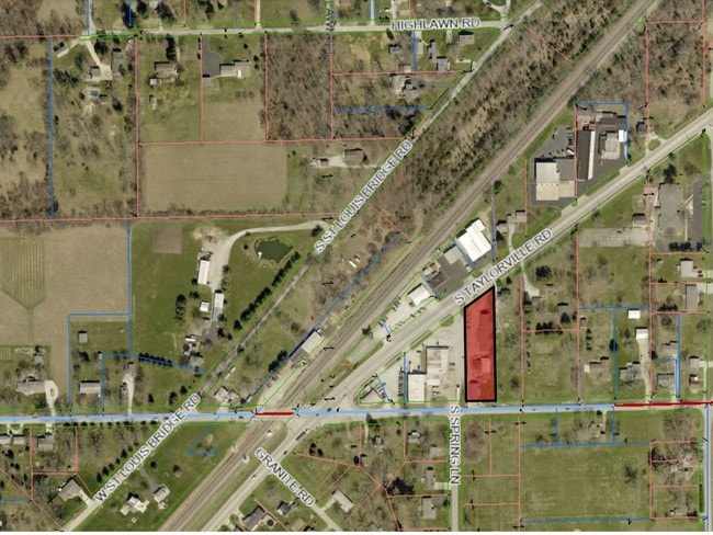
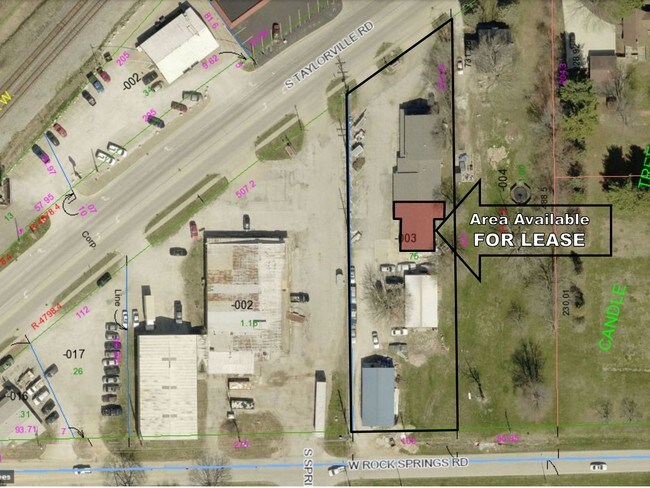
1928 S Taylorville Rd, Decatur, IL 62521

NEARBY LISTINGS FOR SALE OR LEASE
Property Detail
1928 S Taylorville Rd
04-12-21-379-003
E 100 LYING S OF ST ROW OF ~W 8.79CHS OF N11.14CHS SE1/4 ~SW1/4 ~03BK3355/544 ~58 03 1 01 0433 000 00 ~94BK2893/478 ~02BK3226
Retailwithmorethanonenonretailuse
Macon
X
Illinois
17115C0305E
0.75 AC
2024
Springfield/Decatur
2024
Other Market Areas
001500
Decatur, IL
DEMOGRAPHICS near 1928 S Taylorville Rd
1 Mile
3 Mile
5 Mile
2024 Total Population
1,197
32,480
62,523
2029 Population
1,155
31,911
61,241
Pop Growth 2024-2029
(3.51%)
(1.75%)
(2.05%)
Average Age
48
40
41
2024 Total Households
541
13,655
27,203
HH Growth 2024-2029
(3.70%)
(1.78%)
(2.14%)
Median Household Inc
$89,423
$42,381
$42,327
Avg Household Size
2.10
2.20
2.10
2024 Avg HH Vehicles
2.00
2.00
2.00
Median Home Value
$128,802
$86,366
$87,764
Median Year Built
1960
1954
1957
Nearby Places
Map Layers
Map Styles
 Street
 Aerial
- Restaurants
- Banks
- Shops
- Fitness
- Groceries
SALE & LEASE HISTORY
LISTING DATE
SALE/LEASE

Mar 27, 2017
For Lease
Nearby Properties
Address
Land Use
TOTAL SIZE
Lot Size
Zoning
Address
Land Use
TOTAL SIZE
Lot Size
Zoning
1.40 AC
MUNICIPAL
Address
Land Use
TOTAL SIZE
Lot Size
Zoning
8.48 AC
MUNICIPAL
Address
Land Use
TOTAL SIZE
Lot Size
Zoning
6.68 AC
MUNICIPAL
Address
Land Use
TOTAL SIZE
Lot Size
Zoning
7.82 AC
MUNICIPAL
Address
Land Use
TOTAL SIZE
Lot Size
Zoning
1.72 AC
MUNICIPAL
Address
Land Use
TOTAL SIZE
Lot Size
Zoning
1.10 AC
MUNICIPAL
Address
Land Use
TOTAL SIZE
Lot Size
Zoning
3.93 AC
MUNICIPAL
Address
Land Use
TOTAL SIZE
Lot Size
Zoning
14.33 AC
MUNICIPAL
Address
Land Use
TOTAL SIZE
Lot Size
Zoning
4.30 AC
MUNICIPAL
Address
Land Use
TOTAL SIZE
Lot Size
Zoning
2.62 AC
MUNICIPAL
Address
Land Use
TOTAL SIZE
Lot Size
Zoning
2.59 AC
MUNICIPAL
Address
Land Use
TOTAL SIZE
Lot Size
Zoning
1 AC
MUNICIPAL
Address
Land Use
TOTAL SIZE
Lot Size
Zoning
4.38 AC
MUNICIPAL
Address
Land Use
TOTAL SIZE
Lot Size
Zoning
2.50 AC
MUNICIPAL
Address
Land Use
TOTAL SIZE
Lot Size
Zoning
3.54 AC
MUNICIPAL
Address
Land Use
TOTAL SIZE
Lot Size
Zoning
13.97 AC
MUNICIPAL
Address
Land Use
TOTAL SIZE
Lot Size
Zoning
0.45 AC
MUNICIPAL
Address
Land Use
TOTAL SIZE
Lot Size
Zoning
16.25 AC
MUNICIPAL
Address
Land Use
TOTAL SIZE
Lot Size
Zoning
26.06 AC
MUNICIPAL
Address
Land Use
TOTAL SIZE
Lot Size
Zoning
6.81 AC
MUNICIPAL
Address
Land Use
TOTAL SIZE
Lot Size
Zoning
0.55 AC
MUNICIPAL
Address
Land Use
TOTAL SIZE
Lot Size
Zoning
0.72 AC
MUNICIPAL
Address
Land Use
TOTAL SIZE
Lot Size
Zoning
9.50 AC
MUNICIPAL
Address
Land Use
TOTAL SIZE
Lot Size
Zoning
2,828 SF
1.07 AC
MUNICIPAL
Address
Land Use
TOTAL SIZE
Lot Size
Zoning
1.93 AC
MUNICIPAL
Address
Land Use
TOTAL SIZE
Lot Size
Zoning
1.94 AC
MUNICIPAL
Address
Land Use
TOTAL SIZE
Lot Size
Zoning
3.93 AC
MUNICIPAL
Address
Land Use
TOTAL SIZE
Lot Size
Zoning
1.22 AC
MUNICIPAL
The World's #1 Commercial Real Estate Marketplace
Connect with us
© 2026 CoStar Group
The information above has been obtained from sources believed reliable. While we do not doubt its accuracy we have not verified it and make no guarantee, warranty or representation about it. It is your responsibility to independently confirm its accuracy and completeness. Any projections, opinions, assumptions, or estimates used are for example only and do not represent the current or future performance of the property. The value of this transaction to you depends on tax and other factors which should be evaluated by your tax, financial, and legal advisors. You and your advisors should conduct a careful, independent investigation of the property to determine to your satisfaction the suitability of the property for your needs.