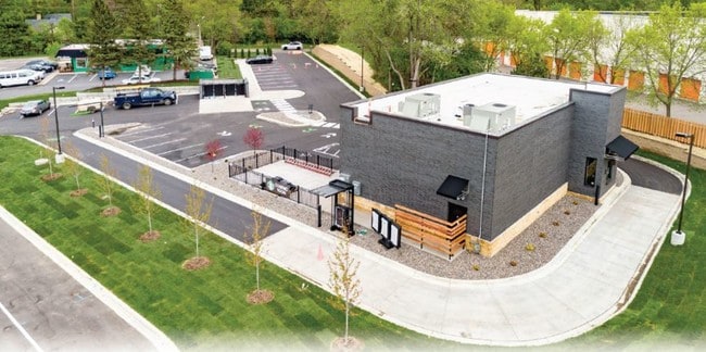
Property Record
19285 Highway 7, Excelsior, MN 55331

NEARBY LISTINGS FOR SALE OR LEASE
Property Detail
19285 Highway 7
Minneapolis-St. Paul-Bloomington, MN-WI
Vine Hill
25-117-23-41-0048
LOT 015 A VINE HILL THAT PART OF LOT 15 DESCRIBED AS BEGINNING AT A POINT 197.6 FEET WEST FROM A POINT IN THE EAST LINE OF SAID LOT 15 DISTANT 395 FEET SOUTH FROM T IRREGULAR
Commercialnec
Hennepin
X
Minnesota
27019C0117D
15
2024
0.84 AC
2024
I-394 Corridor
027504
Minneapolis/St Paul
DEMOGRAPHICS near 19285 Highway 7
1 mile
3 mile
5 mile
2024 Total Population
5,046
44,151
104,888
2029 Population
4,949
43,912
105,207
Pop Growth 2024-2029
(1.92%)
(0.54%)
+ 0.30%
Average Age
43
43
43
2024 Total Households
1,945
16,938
41,491
HH Growth 2024-2029
(2.06%)
(0.71%)
+ 0.24%
Median Household Inc
$133,234
$131,150
$122,760
Avg Household Size
2.50
2.50
2.50
2024 Avg HH Vehicles
2.00
2.00
2.00
Median Home Value
$512,792
$468,688
$473,497
Median Year Built
1978
1979
1982
Nearby Places
Map Layers
Map Styles
 Street
 Aerial
Transit
 Traffic
 Biking
Places
Listings with unknown addresses are not visible on the map
- Restaurants
- Banks
- Shops
- Fitness
- Groceries
PUBLIC TRANSPORTATION
AIRPORT
Minneapolis-St Paul International/Wold-Chamberlain
Drive
Walk
Distance
Minneapolis-St Paul International/Wold-Chamberlain
29 min
20.0 mi
Nearby Properties
Address
Land Use
TOTAL SIZE
Lot Size
Zoning
Address
Land Use
TOTAL SIZE
Lot Size
Zoning
46,726 SF
2.65 AC
PUD
Address
Land Use
TOTAL SIZE
Lot Size
Zoning
29,127 SF
6.89 AC
Address
Land Use
TOTAL SIZE
Lot Size
Zoning
3.82 AC
Address
Land Use
TOTAL SIZE
Lot Size
Zoning
7.06 AC
PUD
Address
Land Use
TOTAL SIZE
Lot Size
Zoning
7,209 SF
2.53 AC
B1
Address
Land Use
TOTAL SIZE
Lot Size
Zoning
1.85 AC
Address
Land Use
TOTAL SIZE
Lot Size
Zoning
29,091 SF
34.94 AC
PUD
Address
Land Use
TOTAL SIZE
Lot Size
Zoning
7.82 AC
R4
Address
Land Use
TOTAL SIZE
Lot Size
Zoning
Address
Land Use
TOTAL SIZE
Lot Size
Zoning
17.67 AC
R4
Address
Land Use
TOTAL SIZE
Lot Size
Zoning
9.29 AC
R4
Address
Land Use
TOTAL SIZE
Lot Size
Zoning
88,948 SF
10.14 AC
B2
Address
Land Use
TOTAL SIZE
Lot Size
Zoning
14.04 AC
R4
Address
Land Use
TOTAL SIZE
Lot Size
Zoning
38,825 SF
5.38 AC
B3
Address
Land Use
TOTAL SIZE
Lot Size
Zoning
10,528 SF
3.83 AC
Address
Land Use
TOTAL SIZE
Lot Size
Zoning
9,892 SF
2.24 AC
Address
Land Use
TOTAL SIZE
Lot Size
Zoning
15,486 SF
2.47 AC
Address
Land Use
TOTAL SIZE
Lot Size
Zoning
1,000 SF
14 AC
Address
Land Use
TOTAL SIZE
Lot Size
Zoning
9,380 SF
3.58 AC
Address
Land Use
TOTAL SIZE
Lot Size
Zoning
11,543 SF
2.39 AC
Address
Land Use
TOTAL SIZE
Lot Size
Zoning
16,407 SF
1.80 AC
Address
Land Use
TOTAL SIZE
Lot Size
Zoning
12,993 SF
2.22 AC
R5
Address
Land Use
TOTAL SIZE
Lot Size
Zoning
Address
Land Use
TOTAL SIZE
Lot Size
Zoning
Address
Land Use
TOTAL SIZE
Lot Size
Zoning
10,327 SF
3.54 AC
Address
Land Use
TOTAL SIZE
Lot Size
Zoning
7,556 SF
2.55 AC
Address
Land Use
TOTAL SIZE
Lot Size
Zoning
9,605 SF
1.91 AC
Address
Land Use
TOTAL SIZE
Lot Size
Zoning
15,547 SF
2.53 AC
Address
Land Use
TOTAL SIZE
Lot Size
Zoning
1.67 AC
Address
Land Use
TOTAL SIZE
Lot Size
Zoning
8,843 SF
0.68 AC
The World's #1 Commercial Real Estate Marketplace
Connect with us
© 2026 CoStar Group
The information above has been obtained from sources believed reliable. While we do not doubt its accuracy we have not verified it and make no guarantee, warranty or representation about it. It is your responsibility to independently confirm its accuracy and completeness. Any projections, opinions, assumptions, or estimates used are for example only and do not represent the current or future performance of the property. The value of this transaction to you depends on tax and other factors which should be evaluated by your tax, financial, and legal advisors. You and your advisors should conduct a careful, independent investigation of the property to determine to your satisfaction the suitability of the property for your needs.