Property Record
1929 County Road 221, Florence, TX 76527


Save to a Folder
{{folder.Name}}
{{folder.ListingIds.length}} Properties
{{folder.ListingIds.length}} Property
Create a New Folder
Property Detail
1929 County Road 221
R010558
AW0645 AW0645 - WARE, J. SUR., ACRES 54.32
Agriculturalland
WILLIAMSON
B and X Area of moderate flood hazard, usually the area between the limits of the 100-year and 500-year floods.
Texas
2024
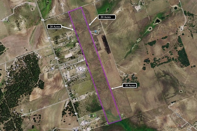
54.32 AC
2025
Georgetown
020206
Austin
3,725 SF
Austin-Round Rock-San Marcos, TX
NEARBY LISTINGS FOR SALE OR LEASE
-
-
View all Florence listings for sale on LoopNet.com
DEMOGRAPHICS near 1929 County Road 221
1 mile
3 mile
5 mile
2025 Total Population
406
1,157
3,187
2030 Population
450
1,302
3,596
Pop Growth 2025-2030
+ 10.84%
+ 12.53%
+ 12.83%
Average Age
40
41
40
2025 Total Households
136
399
1,078
HH Growth 2025-2030
+ 11.76%
+ 12.78%
+ 13.17%
Median Household Inc
$107,291
$116,840
$110,761
Avg Household Size
2.90
2.80
2.90
2025 Avg HH Vehicles
2.00
3.00
2.00
Median Home Value
$399,999
$437,301
$444,444
Median Year Built
2002
2003
2003
Nearby Places
Map Layers
Map Styles
 Street
 Aerial
Layers
 Traffic
 Biking
Places
Listings with unknown addresses are not visible on the map
- Restaurants
- Banks
- Shops
- Fitness
- Groceries
PUBLIC TRANSPORTATION
AIRPORT
Robert Gray AAF
Drive
Walk
Distance
Robert Gray AAF
41 min
22.7 mi
Killeen Municipal
Drive
Walk
Distance
Killeen Municipal
40 min
30.1 mi
Freight Ports
Calhoun Port
Drive
Walk
Distance
Calhoun Port
233 min
197.0 mi
SALE & LEASE HISTORY
LISTING DATE
SALE/LEASE

Sep 10, 2019
For Sale
Nearby Properties
Address
Land Use
TOTAL SIZE
Lot Size
Zoning
Address
Land Use
TOTAL SIZE
Lot Size
Zoning
3,618 SF
11.47 AC
Address
Land Use
TOTAL SIZE
Lot Size
Zoning
13,200 SF
40.04 AC
Address
Land Use
TOTAL SIZE
Lot Size
Zoning
7,500 SF
9.16 AC
Address
Land Use
TOTAL SIZE
Lot Size
Zoning
Address
Land Use
TOTAL SIZE
Lot Size
Zoning
9,744 SF
5 AC
Address
Land Use
TOTAL SIZE
Lot Size
Zoning
7,669 SF
10 AC
Address
Land Use
TOTAL SIZE
Lot Size
Zoning
10,242 SF
57.72 AC
Address
Land Use
TOTAL SIZE
Lot Size
Zoning
7,500 SF
5 AC
Address
Land Use
TOTAL SIZE
Lot Size
Zoning
3,164 SF
5 AC
Address
Land Use
TOTAL SIZE
Lot Size
Zoning
38.81 AC
Address
Land Use
TOTAL SIZE
Lot Size
Zoning
42.95 AC
Address
Land Use
TOTAL SIZE
Lot Size
Zoning
4,071 SF
1.57 AC
Address
Land Use
TOTAL SIZE
Lot Size
Zoning
6,000 SF
18.82 AC
Address
Land Use
TOTAL SIZE
Lot Size
Zoning
3,740 SF
10.43 AC
Address
Land Use
TOTAL SIZE
Lot Size
Zoning
8,352 SF
4.99 AC
Address
Land Use
TOTAL SIZE
Lot Size
Zoning
4,271 SF
73.49 AC
Address
Land Use
TOTAL SIZE
Lot Size
Zoning
3,420 SF
22.24 AC
Address
Land Use
TOTAL SIZE
Lot Size
Zoning
3,888 SF
2.02 AC
Address
Land Use
TOTAL SIZE
Lot Size
Zoning
926 SF
16.67 AC
Address
Land Use
TOTAL SIZE
Lot Size
Zoning
2,996 SF
11.06 AC
Address
Land Use
TOTAL SIZE
Lot Size
Zoning
7.50 AC
Address
Land Use
TOTAL SIZE
Lot Size
Zoning
23.08 AC
Address
Land Use
TOTAL SIZE
Lot Size
Zoning
4,026 SF
5 AC
Address
Land Use
TOTAL SIZE
Lot Size
Zoning
2,414 SF
12.81 AC
Address
Land Use
TOTAL SIZE
Lot Size
Zoning
2,419 SF
194.26 AC
Address
Land Use
TOTAL SIZE
Lot Size
Zoning
2,666 SF
10.78 AC
Address
Land Use
TOTAL SIZE
Lot Size
Zoning
3,200 SF
5 AC
Address
Land Use
TOTAL SIZE
Lot Size
Zoning
15.37 AC
Address
Land Use
TOTAL SIZE
Lot Size
Zoning
20.15 AC
Address
Land Use
TOTAL SIZE
Lot Size
Zoning
14.82 AC
The World's #1 Commercial Real Estate Marketplace
Connect with us
© 2026 CoStar Group
The information above has been obtained from sources believed reliable. While we do not doubt its accuracy we have not verified it and make no guarantee, warranty or representation about it. It is your responsibility to independently confirm its accuracy and completeness. Any projections, opinions, assumptions, or estimates used are for example only and do not represent the current or future performance of the property. The value of this transaction to you depends on tax and other factors which should be evaluated by your tax, financial, and legal advisors. You and your advisors should conduct a careful, independent investigation of the property to determine to your satisfaction the suitability of the property for your needs.