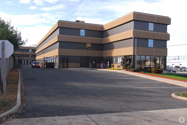
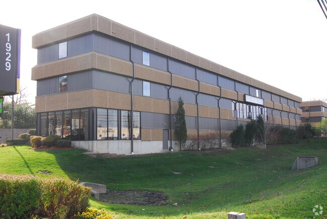
Property Record
1929 Route 37 E, Toms River, NJ 08753

Property Detail
1929 Route 37 E
08-00798-0000-00041
2.299AC
Commercialnec
Ocean
SPLT
New Jersey
B and X Area of moderate flood hazard, usually the area between the limits of the 100-year and 500-year floods.
41
2025
2.30 AC
2025
Ocean County
723500
Northern New Jersey
38,100 SF
Lakewood-New Brunswick, NJ
NEARBY LISTINGS FOR SALE OR LEASE
-
-
View all Toms River listings for sale on LoopNet.com
DEMOGRAPHICS near 1929 Route 37 E
1 mile
3 mile
5 mile
2025 Total Population
11,681
61,299
137,679
2030 Population
12,000
62,857
143,969
Pop Growth 2025-2030
+ 2.73%
+ 2.54%
+ 4.57%
Average Age
39
40
42
2025 Total Households
4,310
22,385
53,257
HH Growth 2025-2030
+ 2.20%
+ 2.05%
+ 4.82%
Median Household Inc
$90,330
$100,308
$94,591
Avg Household Size
2.60
2.60
2.50
2025 Avg HH Vehicles
2.00
2.00
2.00
Median Home Value
$365,175
$394,008
$427,664
Median Year Built
1968
1974
1975
Nearby Places
Map Layers
Map Styles
 Street
 Aerial
Layers
 Traffic
 Biking
Places
Listings with unknown addresses are not visible on the map
- Restaurants
- Banks
- Shops
- Fitness
- Groceries
Nearby Properties
Address
Land Use
TOTAL SIZE
Lot Size
Zoning
Address
Land Use
TOTAL SIZE
Lot Size
Zoning
70.33 AC
RC
Address
Land Use
TOTAL SIZE
Lot Size
Zoning
14,136 SF
11.85 AC
VO
Address
Land Use
TOTAL SIZE
Lot Size
Zoning
8,512 SF
25.67 AC
RC
Address
Land Use
TOTAL SIZE
Lot Size
Zoning
8,118 SF
72.32 AC
R75
Address
Land Use
TOTAL SIZE
Lot Size
Zoning
8.21 AC
VO
Address
Land Use
TOTAL SIZE
Lot Size
Zoning
8,968 SF
26.36 AC
RMF
Address
Land Use
TOTAL SIZE
Lot Size
Zoning
1,332 SF
13.76 AC
EM18
Address
Land Use
TOTAL SIZE
Lot Size
Zoning
18,890 SF
24.59 AC
SPLT
Address
Land Use
TOTAL SIZE
Lot Size
Zoning
57,008 SF
8.85 AC
SPLT
Address
Land Use
TOTAL SIZE
Lot Size
Zoning
15.68 AC
MF8
Address
Land Use
TOTAL SIZE
Lot Size
Zoning
3,997 SF
11.09 AC
RC
Address
Land Use
TOTAL SIZE
Lot Size
Zoning
71,285 SF
20.49 AC
HB
Address
Land Use
TOTAL SIZE
Lot Size
Zoning
9,874 SF
15.17 AC
RC
Address
Land Use
TOTAL SIZE
Lot Size
Zoning
1,680 SF
14.33 AC
HB
Address
Land Use
TOTAL SIZE
Lot Size
Zoning
8.82 AC
O15
Address
Land Use
TOTAL SIZE
Lot Size
Zoning
103,750 SF
24.23 AC
R120
Address
Land Use
TOTAL SIZE
Lot Size
Zoning
33.59 AC
R90
Address
Land Use
TOTAL SIZE
Lot Size
Zoning
2,995 SF
2.14 AC
VO
Address
Land Use
TOTAL SIZE
Lot Size
Zoning
23.28 AC
R75
Address
Land Use
TOTAL SIZE
Lot Size
Zoning
22.29 AC
HB
Address
Land Use
TOTAL SIZE
Lot Size
Zoning
3,524 SF
10 AC
HB
Address
Land Use
TOTAL SIZE
Lot Size
Zoning
3,588 SF
6.81 AC
EM10
Address
Land Use
TOTAL SIZE
Lot Size
Zoning
5,876 SF
3.56 AC
O15
Address
Land Use
TOTAL SIZE
Lot Size
Zoning
36,168 SF
9.52 AC
HB
Address
Land Use
TOTAL SIZE
Lot Size
Zoning
54,648 SF
8.04 AC
HB
Address
Land Use
TOTAL SIZE
Lot Size
Zoning
88,355 SF
5.27 AC
HB
Address
Land Use
TOTAL SIZE
Lot Size
Zoning
2,792 SF
13.72 AC
R100
Address
Land Use
TOTAL SIZE
Lot Size
Zoning
59,100 SF
11.56 AC
HB
Address
Land Use
TOTAL SIZE
Lot Size
Zoning
61,176 SF
9.31 AC
HB
Address
Land Use
TOTAL SIZE
Lot Size
Zoning
10.02 AC
O15
The World's #1 Commercial Real Estate Marketplace
Connect with us
© 2026 CoStar Group
The information above has been obtained from sources believed reliable. While we do not doubt its accuracy we have not verified it and make no guarantee, warranty or representation about it. It is your responsibility to independently confirm its accuracy and completeness. Any projections, opinions, assumptions, or estimates used are for example only and do not represent the current or future performance of the property. The value of this transaction to you depends on tax and other factors which should be evaluated by your tax, financial, and legal advisors. You and your advisors should conduct a careful, independent investigation of the property to determine to your satisfaction the suitability of the property for your needs.