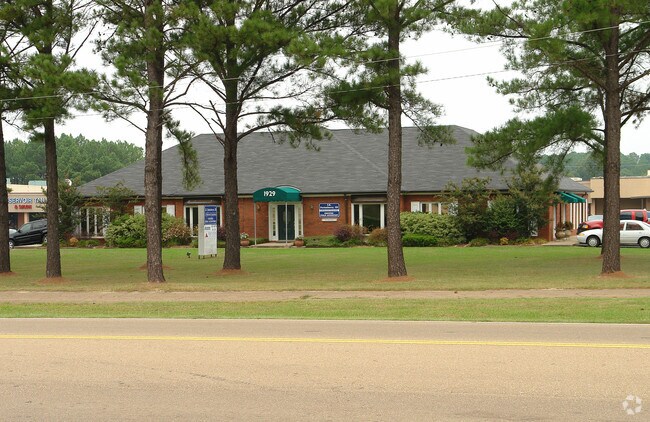
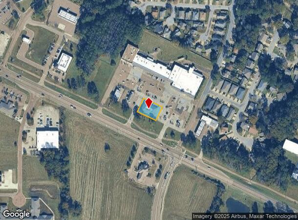
Property Record
1929 Spillway Rd, Brandon, MS 39047

NEARBY LISTINGS FOR SALE OR LEASE
Property Detail
1929 Spillway Rd
H12E-000001-00020
LOT 100 X 140 IN NW4 N SPILLWAY ROAD DB 424 PG 254 0102381 DB 446 PG 0248 0051683 DB 555 PG 0178 0060288 DB 603- 603 PG 0644-
Professionalbldglegalinsurancerealestateetc
Rankin
X
Mississippi
28121C0070G
100
2024
0.32 AC
2024
Outlying Rankin County
020209
Jackson
6,013 SF
Jackson, MS
DEMOGRAPHICS near 1929 Spillway Rd
1 Mile
3 Mile
5 Mile
2024 Total Population
8,081
27,890
59,653
2029 Population
8,352
28,756
61,138
Pop Growth 2024-2029
+ 3.35%
+ 3.11%
+ 2.49%
Average Age
40
40
40
2024 Total Households
3,551
11,482
25,374
HH Growth 2024-2029
+ 3.46%
+ 3.18%
+ 2.46%
Median Household Inc
$82,796
$90,652
$78,251
Avg Household Size
2.20
2.40
2.30
2024 Avg HH Vehicles
2.00
2.00
2.00
Median Home Value
$224,022
$237,815
$239,176
Median Year Built
1997
1997
1993
Nearby Places
Map Layers
Map Styles
 Street
 Aerial
- Restaurants
- Banks
- Shops
- Fitness
- Groceries
PUBLIC TRANSPORTATION
AIRPORT
Jackson-Medgar Wiley Evers International
DRIVE
WALK
Distance
Jackson-Medgar Wiley Evers International
21 min
10.8 mi
Freight Ports
Port of Gulf Port
DRIVE
WALK
Distance
Port of Gulf Port
210 min
168.5 mi
SALE & LEASE HISTORY
LISTING DATE
SALE/LEASE

Sep 25, 2016
For Lease
Mar 14, 2017
For Lease
Mar 01, 2017
For Lease
Jan 14, 2021
For Lease
Nearby Properties
Address
Land Use
TOTAL SIZE
Lot Size
Zoning
Address
Land Use
TOTAL SIZE
Lot Size
Zoning
4,902 SF
31.76 AC
Address
Land Use
TOTAL SIZE
Lot Size
Zoning
8,030 SF
222.20 AC
Address
Land Use
TOTAL SIZE
Lot Size
Zoning
3,624 SF
241.98 AC
Address
Land Use
TOTAL SIZE
Lot Size
Zoning
8,896 SF
12.73 AC
Address
Land Use
TOTAL SIZE
Lot Size
Zoning
1,490 SF
15.24 AC
Address
Land Use
TOTAL SIZE
Lot Size
Zoning
191,219 SF
22.21 AC
Address
Land Use
TOTAL SIZE
Lot Size
Zoning
125,227 SF
8.91 AC
Address
Land Use
TOTAL SIZE
Lot Size
Zoning
19,971 SF
9.56 AC
Address
Land Use
TOTAL SIZE
Lot Size
Zoning
12,416 SF
9.22 AC
Address
Land Use
TOTAL SIZE
Lot Size
Zoning
12,464 SF
9.79 AC
Address
Land Use
TOTAL SIZE
Lot Size
Zoning
3,358 SF
6.12 AC
Address
Land Use
TOTAL SIZE
Lot Size
Zoning
11,284 SF
7.60 AC
Address
Land Use
TOTAL SIZE
Lot Size
Zoning
47,009 SF
6.85 AC
Address
Land Use
TOTAL SIZE
Lot Size
Zoning
2,853 SF
8.68 AC
Address
Land Use
TOTAL SIZE
Lot Size
Zoning
78,049 SF
5.44 AC
Address
Land Use
TOTAL SIZE
Lot Size
Zoning
63,403 SF
7.69 AC
Address
Land Use
TOTAL SIZE
Lot Size
Zoning
19,300 SF
5.98 AC
Address
Land Use
TOTAL SIZE
Lot Size
Zoning
76,236 SF
8.05 AC
Address
Land Use
TOTAL SIZE
Lot Size
Zoning
48,637 SF
2.55 AC
Address
Land Use
TOTAL SIZE
Lot Size
Zoning
41,992 SF
2.17 AC
Address
Land Use
TOTAL SIZE
Lot Size
Zoning
11,447 SF
9.63 AC
Address
Land Use
TOTAL SIZE
Lot Size
Zoning
5,915 SF
0.73 AC
Address
Land Use
TOTAL SIZE
Lot Size
Zoning
83,567 SF
4.68 AC
Address
Land Use
TOTAL SIZE
Lot Size
Zoning
55,380 SF
7.79 AC
Address
Land Use
TOTAL SIZE
Lot Size
Zoning
56,249 SF
5.28 AC
Address
Land Use
TOTAL SIZE
Lot Size
Zoning
43,433 SF
0.95 AC
Address
Land Use
TOTAL SIZE
Lot Size
Zoning
6.98 AC
Address
Land Use
TOTAL SIZE
Lot Size
Zoning
43,549 SF
5.96 AC
Address
Land Use
TOTAL SIZE
Lot Size
Zoning
4,670 SF
2.47 AC
The World's #1 Commercial Real Estate Marketplace
Connect with us
© 2026 CoStar Group
The information above has been obtained from sources believed reliable. While we do not doubt its accuracy we have not verified it and make no guarantee, warranty or representation about it. It is your responsibility to independently confirm its accuracy and completeness. Any projections, opinions, assumptions, or estimates used are for example only and do not represent the current or future performance of the property. The value of this transaction to you depends on tax and other factors which should be evaluated by your tax, financial, and legal advisors. You and your advisors should conduct a careful, independent investigation of the property to determine to your satisfaction the suitability of the property for your needs.