Property Record
193 Clarks Bridge Rd, Gainesville, GA 30501
NEARBY LISTINGS FOR SALE OR LEASE
Property Detail
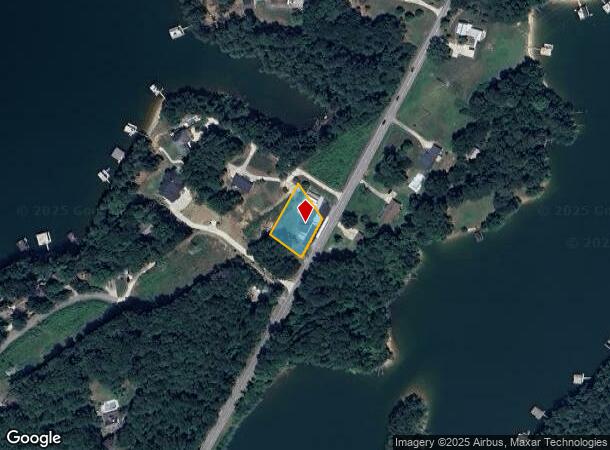
193 Clarks Bridge Rd
Gainesville, GA
Elizabeth Lea Harben & Bu
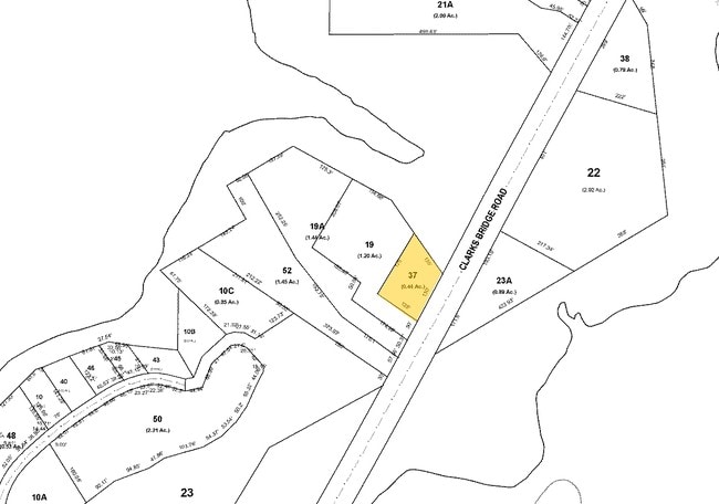
09-00119-00-037
193 CLARKS BRIDGE ROAD
Storebuilding
Hall
X
Georgia
13139C0183G
119
2025
0.45 AC
2025
Gainesville/Hall Cnty
000601
Atlanta
2,510 SF
DEMOGRAPHICS near 193 Clarks Bridge Rd
1 Mile
3 Mile
5 Mile
2024 Total Population
1,567
20,275
53,529
2029 Population
1,730
22,417
59,228
Pop Growth 2024-2029
+ 10.40%
+ 10.56%
+ 10.65%
Average Age
43
41
38
2024 Total Households
610
7,876
19,405
HH Growth 2024-2029
+ 10.66%
+ 10.51%
+ 10.61%
Median Household Inc
$86,444
$58,873
$57,079
Avg Household Size
2.30
2.40
2.60
2024 Avg HH Vehicles
3.00
2.00
2.00
Median Home Value
$369,791
$296,831
$273,750
Median Year Built
1994
1984
1986
Nearby Places
Map Layers
Map Styles
 Street
 Aerial
- Restaurants
- Banks
- Shops
- Fitness
- Groceries
PUBLIC TRANSPORTATION
COMMUTER RAIL
Gainesville Amtrak Station (Crescent - Amtrak)
DRIVE
WALK
Distance
Gainesville Amtrak Station (Crescent - Amtrak)
9 min
5.0 mi
Freight Ports
Georgia Ports - Savannah
DRIVE
WALK
Distance
Georgia Ports - Savannah
323 min
255.5 mi
Nearby Properties
Address
Land Use
TOTAL SIZE
Lot Size
Zoning
Address
Land Use
TOTAL SIZE
Lot Size
Zoning
564,132 SF
48.45 AC
PUD
Address
Land Use
TOTAL SIZE
Lot Size
Zoning
34,131 SF
80.82 AC
L-I
Address
Land Use
TOTAL SIZE
Lot Size
Zoning
39,637 SF
31.55 AC
R-II
Address
Land Use
TOTAL SIZE
Lot Size
Zoning
44,052 SF
19.19 AC
PUD
Address
Land Use
TOTAL SIZE
Lot Size
Zoning
237,470 SF
155.08 AC
L-I
Address
Land Use
TOTAL SIZE
Lot Size
Zoning
2,038 SF
20.92 AC
R-II
Address
Land Use
TOTAL SIZE
Lot Size
Zoning
56,780 SF
16.78 AC
PUD
Address
Land Use
TOTAL SIZE
Lot Size
Zoning
46,795 SF
17.38 AC
PUD
Address
Land Use
TOTAL SIZE
Lot Size
Zoning
102,317 SF
6.90 AC
PUD
Address
Land Use
TOTAL SIZE
Lot Size
Zoning
128,531 SF
13.32 AC
R-I
Address
Land Use
TOTAL SIZE
Lot Size
Zoning
148,619 SF
30.75 AC
O-I
Address
Land Use
TOTAL SIZE
Lot Size
Zoning
54,720 SF
32.52 AC
R-II
Address
Land Use
TOTAL SIZE
Lot Size
Zoning
25,386 SF
30.22 AC
AR-1
Address
Land Use
TOTAL SIZE
Lot Size
Zoning
4,032 SF
89.43 AC
R-I
Address
Land Use
TOTAL SIZE
Lot Size
Zoning
467,600 SF
38.17 AC
L-I
Address
Land Use
TOTAL SIZE
Lot Size
Zoning
63,571 SF
31.97 AC
PUD
Address
Land Use
TOTAL SIZE
Lot Size
Zoning
82,610 SF
13.68 AC
G-B
Address
Land Use
TOTAL SIZE
Lot Size
Zoning
1,628 SF
10.41 AC
PUD
Address
Land Use
TOTAL SIZE
Lot Size
Zoning
328,604 SF
10 AC
I-1
Address
Land Use
TOTAL SIZE
Lot Size
Zoning
69,888 SF
5.37 AC
O-I
Address
Land Use
TOTAL SIZE
Lot Size
Zoning
97,660 SF
7.17 AC
R-II
Address
Land Use
TOTAL SIZE
Lot Size
Zoning
47,432 SF
15.80 AC
R-II
Address
Land Use
TOTAL SIZE
Lot Size
Zoning
28,059 SF
6.33 AC
AR-1
Address
Land Use
TOTAL SIZE
Lot Size
Zoning
6,062 SF
17.54 AC
R-I
Address
Land Use
TOTAL SIZE
Lot Size
Zoning
1,440 SF
10.29 AC
R-II
Address
Land Use
TOTAL SIZE
Lot Size
Zoning
118,917 SF
14.81 AC
PUD
Address
Land Use
TOTAL SIZE
Lot Size
Zoning
11,448 SF
R-II
Address
Land Use
TOTAL SIZE
Lot Size
Zoning
35,748 SF
10 AC
I-1
Address
Land Use
TOTAL SIZE
Lot Size
Zoning
69,888 SF
4.52 AC
O-I
Address
Land Use
TOTAL SIZE
Lot Size
Zoning
39,880 SF
7.93 AC
R-B
The World's #1 Commercial Real Estate Marketplace
Connect with us
© 2025 CoStar Group
The information above has been obtained from sources believed reliable. While we do not doubt its accuracy we have not verified it and make no guarantee, warranty or representation about it. It is your responsibility to independently confirm its accuracy and completeness. Any projections, opinions, assumptions, or estimates used are for example only and do not represent the current or future performance of the property. The value of this transaction to you depends on tax and other factors which should be evaluated by your tax, financial, and legal advisors. You and your advisors should conduct a careful, independent investigation of the property to determine to your satisfaction the suitability of the property for your needs.