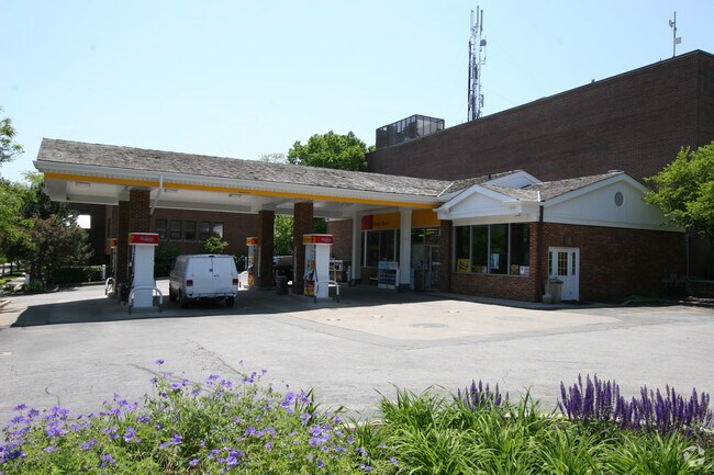
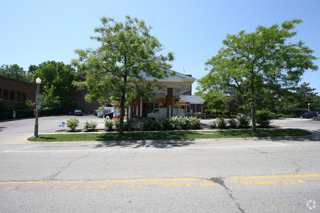
Property Record
193 E Deerpath, Lake Forest, IL 60045

Property Detail
193 E Deerpath
Chicago-Naperville-Elgin, IL-IN
CITY OF LAKE FOREST (EX S 75 FT) N 14RDS LOT 328
12-33-118-007
Lake
Commercialbuilding
Illinois
B and X Area of moderate flood hazard, usually the area between the limits of the 100-year and 500-year floods.
328
2023
0.24 AC
2024
Central North
863500
Chicago
1,800 SF
NEARBY LISTINGS FOR SALE OR LEASE
DEMOGRAPHICS near 193 E Deerpath
1 mile
3 mile
5 mile
2025 Total Population
5,885
26,778
76,704
2030 Population
6,011
27,218
77,852
Pop Growth 2025-2030
+ 2.14%
+ 1.64%
+ 1.50%
Average Age
43
43
39
2025 Total Households
2,199
9,568
24,106
HH Growth 2025-2030
+ 2.14%
+ 1.65%
+ 1.80%
Median Household Inc
$179,824
$199,106
$135,274
Avg Household Size
2.30
2.60
2.60
2025 Avg HH Vehicles
2.00
2.00
2.00
Median Home Value
$815,503
$876,777
$739,415
Median Year Built
1970
1972
1974
Nearby Places
Map Layers
Map Styles
 Street
 Aerial
Transit
 Traffic
 Biking
Places
Listings with unknown addresses are not visible on the map
- Restaurants
- Banks
- Shops
- Fitness
- Groceries
PUBLIC TRANSPORTATION
COMMUTER RAIL
Lake Forest Station (UP-North) (Union Pacific North Line - Northeast Illinois Regional Commuter Railroad (Metra))
Drive
Walk
Distance
Lake Forest Station (UP-North) (Union Pacific North Line - Northeast Illinois Regional Commuter Railroad (Metra))
1 min
7 min
0.2 mi
Lake Bluff Station (Union Pacific North Line - Northeast Illinois Regional Commuter Railroad (Metra))
Drive
Walk
Distance
Lake Bluff Station (Union Pacific North Line - Northeast Illinois Regional Commuter Railroad (Metra))
6 min
2.7 mi
AIRPORT
Chicago O'Hare International
Drive
Walk
Distance
Chicago O'Hare International
35 min
24.5 mi
Chicago Midway International
Drive
Walk
Distance
Chicago Midway International
55 min
36.7 mi
Nearby Properties
Address
Land Use
TOTAL SIZE
Lot Size
Zoning
Address
Land Use
TOTAL SIZE
Lot Size
Zoning
51,750 SF
48.98 AC
Address
Land Use
TOTAL SIZE
Lot Size
Zoning
17.35 AC
Address
Land Use
TOTAL SIZE
Lot Size
Zoning
253,218 SF
2.88 AC
Address
Land Use
TOTAL SIZE
Lot Size
Zoning
7.98 AC
Address
Land Use
TOTAL SIZE
Lot Size
Zoning
70,404 SF
0.65 AC
Address
Land Use
TOTAL SIZE
Lot Size
Zoning
25.66 AC
Address
Land Use
TOTAL SIZE
Lot Size
Zoning
10.68 AC
Address
Land Use
TOTAL SIZE
Lot Size
Zoning
15.47 AC
Address
Land Use
TOTAL SIZE
Lot Size
Zoning
16.06 AC
Address
Land Use
TOTAL SIZE
Lot Size
Zoning
7.99 AC
Address
Land Use
TOTAL SIZE
Lot Size
Zoning
15.18 AC
Address
Land Use
TOTAL SIZE
Lot Size
Zoning
3.57 AC
Address
Land Use
TOTAL SIZE
Lot Size
Zoning
8.81 AC
Address
Land Use
TOTAL SIZE
Lot Size
Zoning
68,100 SF
1.28 AC
Address
Land Use
TOTAL SIZE
Lot Size
Zoning
32,017 SF
1.83 AC
Address
Land Use
TOTAL SIZE
Lot Size
Zoning
9.04 AC
Address
Land Use
TOTAL SIZE
Lot Size
Zoning
248,232 SF
18.91 AC
Address
Land Use
TOTAL SIZE
Lot Size
Zoning
94,995 SF
7.67 AC
Address
Land Use
TOTAL SIZE
Lot Size
Zoning
93,489 SF
0.36 AC
Address
Land Use
TOTAL SIZE
Lot Size
Zoning
78,466 SF
13.34 AC
Address
Land Use
TOTAL SIZE
Lot Size
Zoning
12.61 AC
Address
Land Use
TOTAL SIZE
Lot Size
Zoning
Address
Land Use
TOTAL SIZE
Lot Size
Zoning
7.42 AC
Address
Land Use
TOTAL SIZE
Lot Size
Zoning
167,664 SF
2.91 AC
Address
Land Use
TOTAL SIZE
Lot Size
Zoning
168,628 SF
1.11 AC
Address
Land Use
TOTAL SIZE
Lot Size
Zoning
65,228 SF
7.70 AC
Address
Land Use
TOTAL SIZE
Lot Size
Zoning
51,564 SF
1.67 AC
Address
Land Use
TOTAL SIZE
Lot Size
Zoning
10.90 AC
Address
Land Use
TOTAL SIZE
Lot Size
Zoning
183,110 SF
7.53 AC
Address
Land Use
TOTAL SIZE
Lot Size
Zoning
The World's #1 Commercial Real Estate Marketplace
Connect with us
© 2026 CoStar Group
The information above has been obtained from sources believed reliable. While we do not doubt its accuracy we have not verified it and make no guarantee, warranty or representation about it. It is your responsibility to independently confirm its accuracy and completeness. Any projections, opinions, assumptions, or estimates used are for example only and do not represent the current or future performance of the property. The value of this transaction to you depends on tax and other factors which should be evaluated by your tax, financial, and legal advisors. You and your advisors should conduct a careful, independent investigation of the property to determine to your satisfaction the suitability of the property for your needs.