Property Record
193 Pound Ridge Rd, Bedford, NY 10506
NEARBY LISTINGS FOR SALE OR LEASE
-
-
View all Bedford listings for sale on LoopNet.com
Property Detail
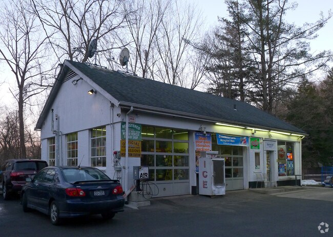
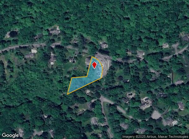
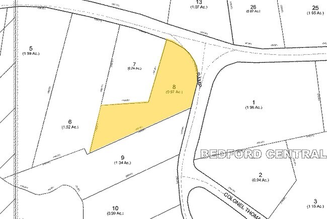
193 Pound Ridge Rd
2000-084-012-00002-000-0008
Westchester
Autorepair
New York
X
8.000
36119C0159F
1 AC
2025
North
2024
Westchester/So Connecticut
012700
New York-Jersey City-White Plains, NY-NJ
DEMOGRAPHICS near 193 Pound Ridge Rd
1 Mile
3 Mile
5 Mile
2024 Total Population
1,498
7,992
31,952
2029 Population
1,468
7,896
31,625
Pop Growth 2024-2029
(2.00%)
(1.20%)
(1.02%)
Average Age
43
43
43
2024 Total Households
513
2,762
10,914
HH Growth 2024-2029
(2.14%)
(1.38%)
(1.17%)
Median Household Inc
$213,455
$230,863
$191,202
Avg Household Size
2.90
2.80
2.80
2024 Avg HH Vehicles
2.00
2.00
2.00
Median Home Value
$943,897
$977,098
$840,837
Median Year Built
1967
1969
1970
Nearby Places
- Restaurants
- Banks
- Shops
- Fitness
- Groceries
PUBLIC TRANSPORTATION
COMMUTER RAIL
Bedford Hills Station (Harlem Line - Metro-North Commuter Railroad Company (Metro-North))
DRIVE
WALK
Distance
Bedford Hills Station (Harlem Line - Metro-North Commuter Railroad Company (Metro-North))
11 min
5.4 mi
Katonah Station (Harlem Line - Metro-North Commuter Railroad Company (Metro-North))
DRIVE
WALK
Distance
Katonah Station (Harlem Line - Metro-North Commuter Railroad Company (Metro-North))
10 min
6.4 mi
AIRPORT
Westchester County
DRIVE
WALK
Distance
Westchester County
20 min
13.3 mi
LaGuardia
DRIVE
WALK
Distance
LaGuardia
60 min
40.4 mi
New York Stewart International
DRIVE
WALK
Distance
New York Stewart International
72 min
45.3 mi
Freight Ports
Port of New Haven
DRIVE
WALK
Distance
Port of New Haven
70 min
49.5 mi
Nearby Properties
Address
Land Use
TOTAL SIZE
Lot Size
Zoning
Address
Land Use
TOTAL SIZE
Lot Size
Zoning
158.56 AC
Address
Land Use
TOTAL SIZE
Lot Size
Zoning
Address
Land Use
TOTAL SIZE
Lot Size
Zoning
1,280 AC
03 - MULTI
Address
Land Use
TOTAL SIZE
Lot Size
Zoning
Address
Land Use
TOTAL SIZE
Lot Size
Zoning
14.14 AC
Address
Land Use
TOTAL SIZE
Lot Size
Zoning
80.94 AC
Address
Land Use
TOTAL SIZE
Lot Size
Zoning
142.69 AC
Address
Land Use
TOTAL SIZE
Lot Size
Zoning
Address
Land Use
TOTAL SIZE
Lot Size
Zoning
4.13 AC
Address
Land Use
TOTAL SIZE
Lot Size
Zoning
Address
Land Use
TOTAL SIZE
Lot Size
Zoning
Address
Land Use
TOTAL SIZE
Lot Size
Zoning
47.50 AC
R4
Address
Land Use
TOTAL SIZE
Lot Size
Zoning
68.91 AC
Address
Land Use
TOTAL SIZE
Lot Size
Zoning
Address
Land Use
TOTAL SIZE
Lot Size
Zoning
112.40 AC
Address
Land Use
TOTAL SIZE
Lot Size
Zoning
Address
Land Use
TOTAL SIZE
Lot Size
Zoning
43.31 AC
Address
Land Use
TOTAL SIZE
Lot Size
Zoning
8.90 AC
R4
Address
Land Use
TOTAL SIZE
Lot Size
Zoning
11.60 AC
Address
Land Use
TOTAL SIZE
Lot Size
Zoning
Address
Land Use
TOTAL SIZE
Lot Size
Zoning
Address
Land Use
TOTAL SIZE
Lot Size
Zoning
10.07 AC
Address
Land Use
TOTAL SIZE
Lot Size
Zoning
5.08 AC
Address
Land Use
TOTAL SIZE
Lot Size
Zoning
24.67 AC
R3A
Address
Land Use
TOTAL SIZE
Lot Size
Zoning
9.11 AC
Address
Land Use
TOTAL SIZE
Lot Size
Zoning
Address
Land Use
TOTAL SIZE
Lot Size
Zoning
13.40 AC
Address
Land Use
TOTAL SIZE
Lot Size
Zoning
3.14 AC
Address
Land Use
TOTAL SIZE
Lot Size
Zoning
6,292 SF
2.82 AC
03 - MULTI
Address
Land Use
TOTAL SIZE
Lot Size
Zoning
64.85 AC
The World's #1 Commercial Real Estate Marketplace
Connect with us
© 2025 CoStar Group
The information above has been obtained from sources believed reliable. While we do not doubt its accuracy we have not verified it and make no guarantee, warranty or representation about it. It is your responsibility to independently confirm its accuracy and completeness. Any projections, opinions, assumptions, or estimates used are for example only and do not represent the current or future performance of the property. The value of this transaction to you depends on tax and other factors which should be evaluated by your tax, financial, and legal advisors. You and your advisors should conduct a careful, independent investigation of the property to determine to your satisfaction the suitability of the property for your needs.