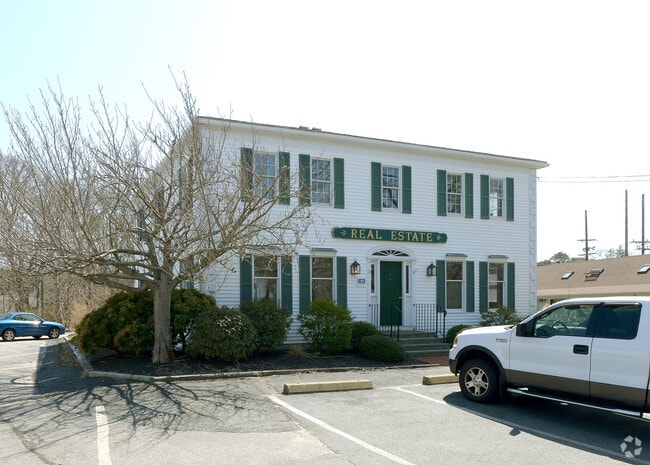
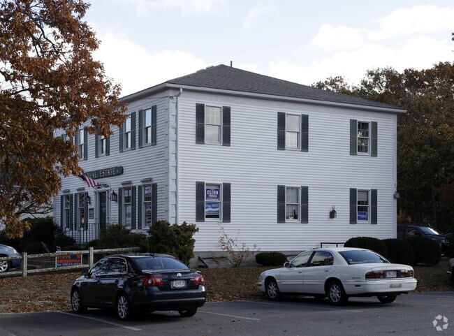
Property Record
193 Rt 6A, Orleans, MA 02653

Save to a Folder
{{folder.Name}}
{{folder.ListingIds.length}} Properties
{{folder.ListingIds.length}} Property
Create a New Folder
Property Detail
193 Rt 6A
Officebuilding
Barnstable
LB
Massachusetts
B and X Area of moderate flood hazard, usually the area between the limits of the 100-year and 500-year floods.
0.29 AC
2025
Cape Cod
2025
Other Market Areas
010400
Barnstable Town, MA
2,880 SF
ORLE-000400-000038
NEARBY LISTINGS FOR SALE OR LEASE
-
-
View all Orleans listings for sale on LoopNet.com
DEMOGRAPHICS near 193 Rt 6A
1 mile
3 mile
5 mile
2025 Total Population
2,104
9,130
19,819
2030 Population
2,067
9,036
19,961
Pop Growth 2025-2030
(1.76%)
(1.03%)
+ 0.72%
Average Age
54
55
53
2025 Total Households
1,068
4,349
9,311
HH Growth 2025-2030
(2.25%)
(1.49%)
+ 0.44%
Median Household Inc
$82,678
$97,733
$94,311
Avg Household Size
1.90
2.00
2.10
2025 Avg HH Vehicles
2.00
2.00
2.00
Median Home Value
$642,761
$788,210
$759,232
Median Year Built
1977
1977
1979
Nearby Places
Map Layers
Map Styles
 Street
 Aerial
Layers
 Traffic
 Biking
Places
Listings with unknown addresses are not visible on the map
- Restaurants
- Banks
- Shops
- Fitness
- Groceries
Nearby Properties
Address
Land Use
TOTAL SIZE
Lot Size
Zoning
Address
Land Use
TOTAL SIZE
Lot Size
Zoning
4,752 SF
54.92 AC
RESD.
Address
Land Use
TOTAL SIZE
Lot Size
Zoning
71,466 SF
12.15 AC
GB
Address
Land Use
TOTAL SIZE
Lot Size
Zoning
90,545 SF
30 AC
R
Address
Land Use
TOTAL SIZE
Lot Size
Zoning
2,661 SF
45.06 AC
RESD.
Address
Land Use
TOTAL SIZE
Lot Size
Zoning
2,872 SF
13.74 AC
R
Address
Land Use
TOTAL SIZE
Lot Size
Zoning
37,957 SF
8.40 AC
RESD.
Address
Land Use
TOTAL SIZE
Lot Size
Zoning
99,086 SF
10.69 AC
GB
Address
Land Use
TOTAL SIZE
Lot Size
Zoning
5,482 SF
450 AC
R
Address
Land Use
TOTAL SIZE
Lot Size
Zoning
54,328 SF
23 AC
R
Address
Land Use
TOTAL SIZE
Lot Size
Zoning
65,651 SF
13.03 AC
RESD.
Address
Land Use
TOTAL SIZE
Lot Size
Zoning
30,248 SF
9.48 AC
VILLAG
Address
Land Use
TOTAL SIZE
Lot Size
Zoning
70,653 SF
12.61 AC
RESD.
Address
Land Use
TOTAL SIZE
Lot Size
Zoning
425 SF
29.52 AC
RESIDE
Address
Land Use
TOTAL SIZE
Lot Size
Zoning
7,384 SF
8.10 AC
R
Address
Land Use
TOTAL SIZE
Lot Size
Zoning
14,406 SF
14.18 AC
GB
Address
Land Use
TOTAL SIZE
Lot Size
Zoning
960 SF
14.20 AC
RESD.
Address
Land Use
TOTAL SIZE
Lot Size
Zoning
5,817 SF
5.75 AC
R
Address
Land Use
TOTAL SIZE
Lot Size
Zoning
2,342 SF
18.70 AC
RESD.
Address
Land Use
TOTAL SIZE
Lot Size
Zoning
5,866 SF
3.68 AC
R
Address
Land Use
TOTAL SIZE
Lot Size
Zoning
4,208 SF
2.86 AC
RESD.
Address
Land Use
TOTAL SIZE
Lot Size
Zoning
15,602 SF
1.32 AC
R
Address
Land Use
TOTAL SIZE
Lot Size
Zoning
33,188 SF
9.97 AC
VILLAG
Address
Land Use
TOTAL SIZE
Lot Size
Zoning
7,711 SF
10.10 AC
R
Address
Land Use
TOTAL SIZE
Lot Size
Zoning
5,221 SF
2.57 AC
RESIDE
Address
Land Use
TOTAL SIZE
Lot Size
Zoning
3,795 SF
4.34 AC
R
Address
Land Use
TOTAL SIZE
Lot Size
Zoning
3,614 SF
1.15 AC
R
Address
Land Use
TOTAL SIZE
Lot Size
Zoning
23,078 SF
3.02 AC
GB
Address
Land Use
TOTAL SIZE
Lot Size
Zoning
27.70 AC
R
Address
Land Use
TOTAL SIZE
Lot Size
Zoning
3,333 SF
2.35 AC
R
Address
Land Use
TOTAL SIZE
Lot Size
Zoning
18,560 SF
6.51 AC
R
The World's #1 Commercial Real Estate Marketplace
Connect with us
© 2026 CoStar Group
The information above has been obtained from sources believed reliable. While we do not doubt its accuracy we have not verified it and make no guarantee, warranty or representation about it. It is your responsibility to independently confirm its accuracy and completeness. Any projections, opinions, assumptions, or estimates used are for example only and do not represent the current or future performance of the property. The value of this transaction to you depends on tax and other factors which should be evaluated by your tax, financial, and legal advisors. You and your advisors should conduct a careful, independent investigation of the property to determine to your satisfaction the suitability of the property for your needs.