Property Record
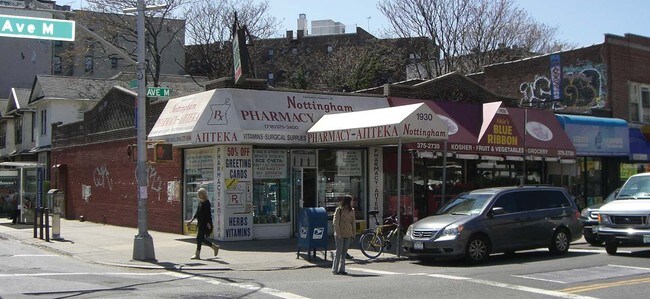
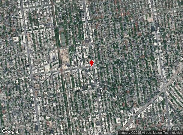
1930 Avenue M, Brooklyn, NY 11230
NEARBY LISTINGS FOR SALE OR LEASE
Property Detail
1930 Avenue M
New York-Jersey City-White Plains, NY-NJ
DOCID-2021061001087001
06748-0011
Kings
Retailwithmorethanonenonretailuse
New York
2023
11
2022
0.17 AC
053800
South Brooklyn
41,478 SF
Long Island (New York)
DEMOGRAPHICS near 1930 Avenue M
1 Mile
3 Mile
5 Mile
2024 Total Population
130,052
1,031,157
1,919,007
2029 Population
123,517
958,077
1,789,075
Pop Growth 2024-2029
(5.02%)
(7.09%)
(6.77%)
Average Age
39
40
40
2024 Total Households
44,055
354,428
698,003
HH Growth 2024-2029
(5.36%)
(7.42%)
(7.08%)
Median Household Inc
$68,765
$65,418
$66,638
Avg Household Size
2.80
2.80
2.60
2024 Avg HH Vehicles
1.00
1.00
1.00
Median Home Value
$844,083
$774,708
$814,773
Median Year Built
1947
1948
1948
Nearby Places
- Restaurants
- Banks
- Shops
- Fitness
- Groceries
PUBLIC TRANSPORTATION
TRANSIT/SUBWAY
Avenue M (Q - New York MTA Subway (The Subway))
DRIVE
WALK
Distance
Avenue M (Q - New York MTA Subway (The Subway))
1 min
4 min
0.2 mi
Avenue J (Q - New York MTA Subway (The Subway))
DRIVE
WALK
Distance
Avenue J (Q - New York MTA Subway (The Subway))
2 min
13 min
0.7 mi
Kings Highway (B,Q Line) (B - New York MTA Subway (The Subway), Q - New York MTA Subway (The Subway))
DRIVE
WALK
Distance
Kings Highway (B,Q Line) (B - New York MTA Subway (The Subway), Q - New York MTA Subway (The Subway))
2 min
16 min
0.8 mi
COMMUTER RAIL
DRIVE
WALK
Distance
13 min
4.9 mi
Nostrand Avenue Station (Far Rockaway Branch - Long Island Rail Road, Hempstead Branch - Long Island Rail Road, Long Beach Branch - Long Island Rail Road, West Hempstead Branch - Long Island Rail Road)
DRIVE
WALK
Distance
Nostrand Avenue Station (Far Rockaway Branch - Long Island Rail Road, Hempstead Branch - Long Island Rail Road, Long Beach Branch - Long Island Rail Road, West Hempstead Branch - Long Island Rail Road)
15 min
5.0 mi
AIRPORT
John F Kennedy International
DRIVE
WALK
Distance
John F Kennedy International
24 min
13.1 mi
LaGuardia
DRIVE
WALK
Distance
LaGuardia
31 min
14.0 mi
Newark Liberty International
DRIVE
WALK
Distance
Newark Liberty International
37 min
20.7 mi
Freight Ports
NY - Red Hook Container Terminal
DRIVE
WALK
Distance
NY - Red Hook Container Terminal
13 min
6.1 mi
SALE & LEASE HISTORY
LISTING DATE
SALE/LEASE

Dec 06, 2017
For Lease
Nearby Properties
Address
Land Use
TOTAL SIZE
Lot Size
Zoning
Address
Land Use
TOTAL SIZE
Lot Size
Zoning
1,281,577 SF
20.78 AC
M3-1
Address
Land Use
TOTAL SIZE
Lot Size
Zoning
1,503,150 SF
20.47 AC
R5
Address
Land Use
TOTAL SIZE
Lot Size
Zoning
1,078,317 SF
10.45 AC
R4
Address
Land Use
TOTAL SIZE
Lot Size
Zoning
10,250 SF
773.50 AC
PARK
Address
Land Use
TOTAL SIZE
Lot Size
Zoning
965,600 SF
6.65 AC
R5
Address
Land Use
TOTAL SIZE
Lot Size
Zoning
1,061,228 SF
8.86 AC
R5
Address
Land Use
TOTAL SIZE
Lot Size
Zoning
1,073,920 SF
16.53 AC
R6
Address
Land Use
TOTAL SIZE
Lot Size
Zoning
561,945 SF
11.58 AC
R6
Address
Land Use
TOTAL SIZE
Lot Size
Zoning
61.60 AC
PARK
Address
Land Use
TOTAL SIZE
Lot Size
Zoning
335,800 SF
1.51 AC
R6
Address
Land Use
TOTAL SIZE
Lot Size
Zoning
785,450 SF
14.22 AC
R6
Address
Land Use
TOTAL SIZE
Lot Size
Zoning
353,600 SF
55.79 AC
R3-1
Address
Land Use
TOTAL SIZE
Lot Size
Zoning
393,092 SF
1.07 AC
R8A
Address
Land Use
TOTAL SIZE
Lot Size
Zoning
371,139 SF
3.22 AC
R5
Address
Land Use
TOTAL SIZE
Lot Size
Zoning
229,456 SF
4.15 AC
M1-1
Address
Land Use
TOTAL SIZE
Lot Size
Zoning
635,994 SF
17.90 AC
R5
Address
Land Use
TOTAL SIZE
Lot Size
Zoning
241,735 SF
1.99 AC
C8-4
Address
Land Use
TOTAL SIZE
Lot Size
Zoning
301,400 SF
22.27 AC
M3-1
Address
Land Use
TOTAL SIZE
Lot Size
Zoning
308,757 SF
0.74 AC
R7-1
Address
Land Use
TOTAL SIZE
Lot Size
Zoning
540,672 SF
10.65 AC
R6
Address
Land Use
TOTAL SIZE
Lot Size
Zoning
75,340 SF
3.02 AC
PARK
Address
Land Use
TOTAL SIZE
Lot Size
Zoning
22.96 AC
PARK
Address
Land Use
TOTAL SIZE
Lot Size
Zoning
139,557 SF
11.47 AC
M1-1
Address
Land Use
TOTAL SIZE
Lot Size
Zoning
7,948 SF
65.50 AC
R4
Address
Land Use
TOTAL SIZE
Lot Size
Zoning
846,056 SF
20.71 AC
R5
Address
Land Use
TOTAL SIZE
Lot Size
Zoning
247,400 SF
4.34 AC
C44A
Address
Land Use
TOTAL SIZE
Lot Size
Zoning
292,528 SF
1.05 AC
R6
Address
Land Use
TOTAL SIZE
Lot Size
Zoning
137,500 SF
2.13 AC
M1-1
Address
Land Use
TOTAL SIZE
Lot Size
Zoning
379,664 SF
8.96 AC
R5
Address
Land Use
TOTAL SIZE
Lot Size
Zoning
356,000 SF
8.19 AC
R5
The World's #1 Commercial Real Estate Marketplace
Connect with us
© 2025 CoStar Group
The information above has been obtained from sources believed reliable. While we do not doubt its accuracy we have not verified it and make no guarantee, warranty or representation about it. It is your responsibility to independently confirm its accuracy and completeness. Any projections, opinions, assumptions, or estimates used are for example only and do not represent the current or future performance of the property. The value of this transaction to you depends on tax and other factors which should be evaluated by your tax, financial, and legal advisors. You and your advisors should conduct a careful, independent investigation of the property to determine to your satisfaction the suitability of the property for your needs.