Property Record
1930 Gadsden Hwy, Birmingham, AL 35235


NEARBY LISTINGS FOR SALE OR LEASE
-
-
View all Birmingham listings for sale on LoopNet.com
Property Detail
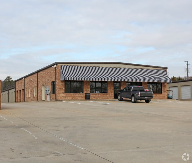
1930 Gadsden Hwy
12-00-27-4-002-005.000
COM NW COR OF SE 1/4 SEC 27 TP 16 R 1W TH E 280 FT TO POB TH CONT SE 175 FT TH SELY 1210 FT TH SWLY 180 FT TH NWLY 1330 FT TO POB SECT 27 TWSP 16S RANGE 1WW
Commercialnec
Jefferson
X
Alabama
01073C0407J
5 AC
2023
Trussville
2024
Birmingham
011108
Birmingham, AL
4,600 SF
DEMOGRAPHICS near 1930 Gadsden Hwy
1 Mile
3 Mile
5 Mile
2024 Total Population
3,997
30,079
78,789
2029 Population
3,846
29,189
76,919
Pop Growth 2024-2029
(3.78%)
(2.96%)
(2.37%)
Average Age
42
39
38
2024 Total Households
1,577
11,463
29,425
HH Growth 2024-2029
(3.99%)
(3.04%)
(2.45%)
Median Household Inc
$89,978
$66,073
$58,328
Avg Household Size
2.40
2.50
2.60
2024 Avg HH Vehicles
2.00
2.00
2.00
Median Home Value
$310,341
$194,848
$171,699
Median Year Built
1997
1984
1977
Nearby Places
Map Layers
Map Styles
 Street
 Aerial
- Restaurants
- Banks
- Shops
- Fitness
- Groceries
PUBLIC TRANSPORTATION
AIRPORT
Birmingham-Shuttlesworth International
DRIVE
WALK
Distance
Birmingham-Shuttlesworth International
16 min
10.6 mi
Nearby Properties
Address
Land Use
TOTAL SIZE
Lot Size
Zoning
Address
Land Use
TOTAL SIZE
Lot Size
Zoning
152,664 SF
12.44 AC
CO&I
Address
Land Use
TOTAL SIZE
Lot Size
Zoning
326,294 SF
25.99 AC
R4&U
Address
Land Use
TOTAL SIZE
Lot Size
Zoning
346,184 SF
21.75 AC
I2
Address
Land Use
TOTAL SIZE
Lot Size
Zoning
128,233 SF
CO&I
Address
Land Use
TOTAL SIZE
Lot Size
Zoning
155,845 SF
17 AC
C2
Address
Land Use
TOTAL SIZE
Lot Size
Zoning
204,463 SF
32.90 AC
PUD
Address
Land Use
TOTAL SIZE
Lot Size
Zoning
144,921 SF
9 AC
R4
Address
Land Use
TOTAL SIZE
Lot Size
Zoning
87,863 SF
13.20 AC
PUD
Address
Land Use
TOTAL SIZE
Lot Size
Zoning
204,269 SF
17.94 AC
PUD
Address
Land Use
TOTAL SIZE
Lot Size
Zoning
94,262 SF
17.30 AC
C-2
Address
Land Use
TOTAL SIZE
Lot Size
Zoning
58,509 SF
CO&I
Address
Land Use
TOTAL SIZE
Lot Size
Zoning
207,383 SF
17 AC
CR5
Address
Land Use
TOTAL SIZE
Lot Size
Zoning
39,890 SF
7.10 AC
R8
Address
Land Use
TOTAL SIZE
Lot Size
Zoning
57,296 SF
CO&I
Address
Land Use
TOTAL SIZE
Lot Size
Zoning
134,442 SF
26 AC
PUD
Address
Land Use
TOTAL SIZE
Lot Size
Zoning
194,730 SF
25 AC
I-1
Address
Land Use
TOTAL SIZE
Lot Size
Zoning
176,232 SF
5.20 AC
C2
Address
Land Use
TOTAL SIZE
Lot Size
Zoning
110,776 SF
11.10 AC
C2
Address
Land Use
TOTAL SIZE
Lot Size
Zoning
34,169 SF
2.56 AC
QC2
Address
Land Use
TOTAL SIZE
Lot Size
Zoning
53,864 SF
6.58 AC
C2
Address
Land Use
TOTAL SIZE
Lot Size
Zoning
49,858 SF
7.30 AC
C4
Address
Land Use
TOTAL SIZE
Lot Size
Zoning
74,218 SF
4.50 AC
C2
Address
Land Use
TOTAL SIZE
Lot Size
Zoning
97,652 SF
6.20 AC
C2
Address
Land Use
TOTAL SIZE
Lot Size
Zoning
89,761 SF
11 AC
PUD
Address
Land Use
TOTAL SIZE
Lot Size
Zoning
170,992 SF
10 AC
C1
Address
Land Use
TOTAL SIZE
Lot Size
Zoning
122,397 SF
13.13 AC
C1
Address
Land Use
TOTAL SIZE
Lot Size
Zoning
40,011 SF
2.05 AC
C1
Address
Land Use
TOTAL SIZE
Lot Size
Zoning
116,732 SF
4.06 AC
R-4
Address
Land Use
TOTAL SIZE
Lot Size
Zoning
76,037 SF
32.40 AC
A1
Address
Land Use
TOTAL SIZE
Lot Size
Zoning
101,606 SF
4.46 AC
C-2
The World's #1 Commercial Real Estate Marketplace
Connect with us
© 2026 CoStar Group
The information above has been obtained from sources believed reliable. While we do not doubt its accuracy we have not verified it and make no guarantee, warranty or representation about it. It is your responsibility to independently confirm its accuracy and completeness. Any projections, opinions, assumptions, or estimates used are for example only and do not represent the current or future performance of the property. The value of this transaction to you depends on tax and other factors which should be evaluated by your tax, financial, and legal advisors. You and your advisors should conduct a careful, independent investigation of the property to determine to your satisfaction the suitability of the property for your needs.