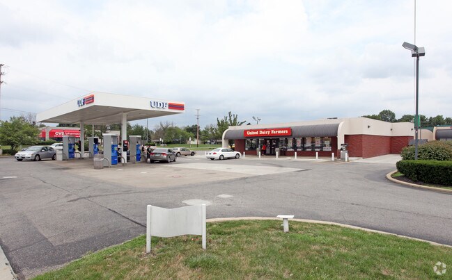
Property Record
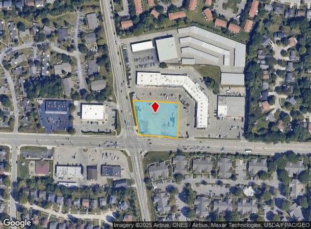
1930 Hard Rd, Columbus Grove, OH 45830

NEARBY LISTINGS FOR SALE OR LEASE
Property Detail
1930 Hard Rd
Columbus, OH
Smokey Row Rd
610-204663
SMOKEY ROW & HARD RD LOT 24 & PT LOT 15 1.155 ACRES
Commercialnec
Franklin
X
Ohio
39049C0152K
24 0
2024
1.16 AC
2024
Bethel Rd
030500
Columbus
9,711 SF
DEMOGRAPHICS near 1930 Hard Rd
1 Mile
3 Mile
5 Mile
2024 Total Population
17,160
77,928
231,604
2029 Population
17,031
79,042
237,461
Pop Growth 2024-2029
(0.75%)
+ 1.43%
+ 2.53%
Average Age
37
39
39
2024 Total Households
6,587
31,298
96,347
HH Growth 2024-2029
(0.79%)
+ 1.46%
+ 2.32%
Median Household Inc
$90,766
$104,128
$92,950
Avg Household Size
2.50
2.40
2.40
2024 Avg HH Vehicles
2.00
2.00
2.00
Median Home Value
$278,817
$354,017
$345,539
Median Year Built
1984
1987
1986
Nearby Places
Map Layers
Map Styles
 Street
 Aerial
- Restaurants
- Banks
- Shops
- Fitness
- Groceries
PUBLIC TRANSPORTATION
AIRPORT
John Glenn Columbus International
DRIVE
WALK
Distance
John Glenn Columbus International
27 min
18.2 mi
Rickenbacker International
DRIVE
WALK
Distance
Rickenbacker International
40 min
28.5 mi
Freight Ports
Port of Toledo
DRIVE
WALK
Distance
Port of Toledo
169 min
133.2 mi
Nearby Properties
Address
Land Use
TOTAL SIZE
Lot Size
Zoning
Address
Land Use
TOTAL SIZE
Lot Size
Zoning
133,425 SF
20.51 AC
Address
Land Use
TOTAL SIZE
Lot Size
Zoning
320,155 SF
84.68 AC
Address
Land Use
TOTAL SIZE
Lot Size
Zoning
557,021 SF
21.28 AC
Address
Land Use
TOTAL SIZE
Lot Size
Zoning
232,579 SF
54.30 AC
Address
Land Use
TOTAL SIZE
Lot Size
Zoning
356,770 SF
2.65 AC
Address
Land Use
TOTAL SIZE
Lot Size
Zoning
173,618 SF
1.13 AC
Address
Land Use
TOTAL SIZE
Lot Size
Zoning
223,270 SF
1.30 AC
Address
Land Use
TOTAL SIZE
Lot Size
Zoning
261,872 SF
53.89 AC
Address
Land Use
TOTAL SIZE
Lot Size
Zoning
200,609 SF
21.87 AC
Address
Land Use
TOTAL SIZE
Lot Size
Zoning
178,568 SF
31.62 AC
Address
Land Use
TOTAL SIZE
Lot Size
Zoning
160,958 SF
11.93 AC
Address
Land Use
TOTAL SIZE
Lot Size
Zoning
115,032 SF
12.81 AC
Address
Land Use
TOTAL SIZE
Lot Size
Zoning
257,993 SF
9.98 AC
Address
Land Use
TOTAL SIZE
Lot Size
Zoning
413,781 SF
78.36 AC
Address
Land Use
TOTAL SIZE
Lot Size
Zoning
323,955 SF
31.18 AC
Address
Land Use
TOTAL SIZE
Lot Size
Zoning
162,728 SF
4.80 AC
Address
Land Use
TOTAL SIZE
Lot Size
Zoning
187,562 SF
8.76 AC
Address
Land Use
TOTAL SIZE
Lot Size
Zoning
216,100 SF
28.17 AC
Address
Land Use
TOTAL SIZE
Lot Size
Zoning
111,376 SF
0.55 AC
Address
Land Use
TOTAL SIZE
Lot Size
Zoning
122,663 SF
0.60 AC
Address
Land Use
TOTAL SIZE
Lot Size
Zoning
123,149 SF
12.09 AC
Address
Land Use
TOTAL SIZE
Lot Size
Zoning
86,934 SF
8.80 AC
Address
Land Use
TOTAL SIZE
Lot Size
Zoning
365,841 SF
30.07 AC
Address
Land Use
TOTAL SIZE
Lot Size
Zoning
183,424 SF
9.21 AC
Address
Land Use
TOTAL SIZE
Lot Size
Zoning
131,905 SF
6.32 AC
Address
Land Use
TOTAL SIZE
Lot Size
Zoning
61,790 SF
6.15 AC
Address
Land Use
TOTAL SIZE
Lot Size
Zoning
112,840 SF
11.68 AC
Address
Land Use
TOTAL SIZE
Lot Size
Zoning
128,522 SF
13.43 AC
Address
Land Use
TOTAL SIZE
Lot Size
Zoning
101,049 SF
0.65 AC
Address
Land Use
TOTAL SIZE
Lot Size
Zoning
69.13 AC
The World's #1 Commercial Real Estate Marketplace
Connect with us
© 2025 CoStar Group
The information above has been obtained from sources believed reliable. While we do not doubt its accuracy we have not verified it and make no guarantee, warranty or representation about it. It is your responsibility to independently confirm its accuracy and completeness. Any projections, opinions, assumptions, or estimates used are for example only and do not represent the current or future performance of the property. The value of this transaction to you depends on tax and other factors which should be evaluated by your tax, financial, and legal advisors. You and your advisors should conduct a careful, independent investigation of the property to determine to your satisfaction the suitability of the property for your needs.