Property Record
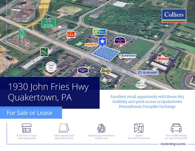
1930 John Fries Hwy, Quakertown, PA 18951
NEARBY LISTINGS FOR SALE OR LEASE
Property Detail
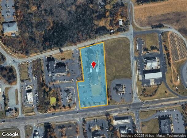
1930 John Fries Hwy
Philadelphia-Camden-Wilmington, PA-NJ-DE-MD
Sohum Hot El Plan
23-010-019-005
3.3685AC LOT #3 SOHUM HOT EL PLAN 270 ON JOHN FRIE S HWY
Restaurantbuilding
Bucks
X
Pennsylvania
42017C0116J
3
2024
3.37 AC
2025
Upper Bucks County
106402
Philadelphia
53,124 SF
DEMOGRAPHICS near 1930 John Fries Hwy
1 Mile
3 Mile
5 Mile
2024 Total Population
1,423
12,667
45,159
2029 Population
1,367
12,449
45,049
Pop Growth 2024-2029
(3.94%)
(1.72%)
(0.24%)
Average Age
42
43
42
2024 Total Households
507
4,601
16,872
HH Growth 2024-2029
(4.14%)
(1.83%)
(0.40%)
Median Household Inc
$158,333
$109,620
$93,647
Avg Household Size
2.70
2.70
2.60
2024 Avg HH Vehicles
3.00
2.00
2.00
Median Home Value
$349,013
$352,584
$321,553
Median Year Built
1991
1986
1980
Nearby Places
- Restaurants
- Banks
- Shops
- Fitness
- Groceries
PUBLIC TRANSPORTATION
AIRPORT
Lehigh Valley International
DRIVE
WALK
Distance
Lehigh Valley International
35 min
23.7 mi
Freight Ports
Port of Philadelphia
DRIVE
WALK
Distance
Port of Philadelphia
61 min
44.9 mi
Nearby Properties
Address
Land Use
TOTAL SIZE
Lot Size
Zoning
Address
Land Use
TOTAL SIZE
Lot Size
Zoning
935,540 SF
76.84 AC
RA
Address
Land Use
TOTAL SIZE
Lot Size
Zoning
145,197 SF
17.11 AC
PC
Address
Land Use
TOTAL SIZE
Lot Size
Zoning
248,895 SF
18.33 AC
I
Address
Land Use
TOTAL SIZE
Lot Size
Zoning
264,600 SF
33.38 AC
PI
Address
Land Use
TOTAL SIZE
Lot Size
Zoning
13,230 SF
23.68 AC
RC
Address
Land Use
TOTAL SIZE
Lot Size
Zoning
127,968 SF
15.38 AC
PC
Address
Land Use
TOTAL SIZE
Lot Size
Zoning
7,391 SF
4.65 AC
RC
Address
Land Use
TOTAL SIZE
Lot Size
Zoning
86,827 SF
11.84 AC
PC
Address
Land Use
TOTAL SIZE
Lot Size
Zoning
215,368 SF
24.49 AC
SRM
Address
Land Use
TOTAL SIZE
Lot Size
Zoning
117,432 SF
11.92 AC
PI
Address
Land Use
TOTAL SIZE
Lot Size
Zoning
125,000 SF
19.58 AC
PI
Address
Land Use
TOTAL SIZE
Lot Size
Zoning
48,457 SF
2.73 AC
PC
Address
Land Use
TOTAL SIZE
Lot Size
Zoning
53,124 SF
3.37 AC
PC
Address
Land Use
TOTAL SIZE
Lot Size
Zoning
83,508 SF
7.91 AC
PI
Address
Land Use
TOTAL SIZE
Lot Size
Zoning
42,417 SF
6.13 AC
PC
Address
Land Use
TOTAL SIZE
Lot Size
Zoning
89,012 SF
29.93 AC
PI
Address
Land Use
TOTAL SIZE
Lot Size
Zoning
53.55 AC
AC
Address
Land Use
TOTAL SIZE
Lot Size
Zoning
75,408 SF
9.63 AC
PI
Address
Land Use
TOTAL SIZE
Lot Size
Zoning
16,114 SF
6.13 AC
PC
Address
Land Use
TOTAL SIZE
Lot Size
Zoning
51.12 AC
RC
Address
Land Use
TOTAL SIZE
Lot Size
Zoning
11.06 AC
PI
Address
Land Use
TOTAL SIZE
Lot Size
Zoning
82,753 SF
7.85 AC
PC
Address
Land Use
TOTAL SIZE
Lot Size
Zoning
61,970 SF
10.19 AC
RA
Address
Land Use
TOTAL SIZE
Lot Size
Zoning
63.42 AC
AC
Address
Land Use
TOTAL SIZE
Lot Size
Zoning
47,016 SF
6.38 AC
PI
Address
Land Use
TOTAL SIZE
Lot Size
Zoning
3,188 SF
16.96 AC
AC
Address
Land Use
TOTAL SIZE
Lot Size
Zoning
32,568 SF
10.63 AC
RD
Address
Land Use
TOTAL SIZE
Lot Size
Zoning
44,415 SF
3.60 AC
PC
Address
Land Use
TOTAL SIZE
Lot Size
Zoning
81,120 SF
8 AC
I
Address
Land Use
TOTAL SIZE
Lot Size
Zoning
19,036 SF
16.40 AC
PC
The World's #1 Commercial Real Estate Marketplace
Connect with us
© 2025 CoStar Group
The information above has been obtained from sources believed reliable. While we do not doubt its accuracy we have not verified it and make no guarantee, warranty or representation about it. It is your responsibility to independently confirm its accuracy and completeness. Any projections, opinions, assumptions, or estimates used are for example only and do not represent the current or future performance of the property. The value of this transaction to you depends on tax and other factors which should be evaluated by your tax, financial, and legal advisors. You and your advisors should conduct a careful, independent investigation of the property to determine to your satisfaction the suitability of the property for your needs.