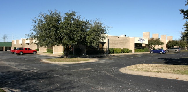
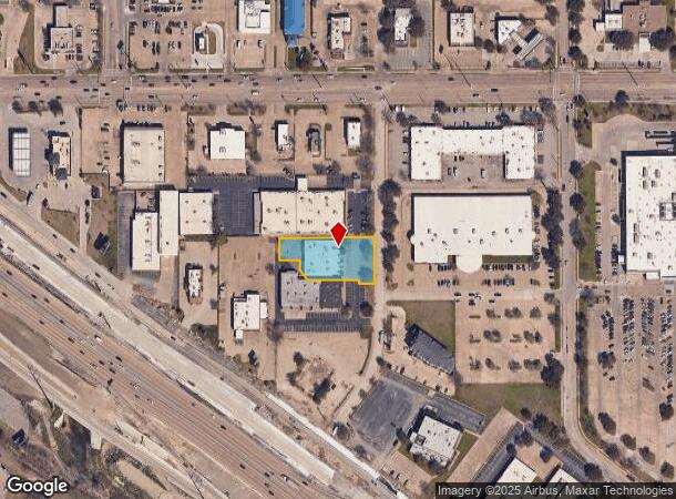
Property Record
1930 Pendleton Dr, Garland, TX 75041

NEARBY LISTINGS FOR SALE OR LEASE
Property Detail
1930 Pendleton Dr
Dallas-Fort Worth-Arlington, TX
Egp2 Klaus
26163550010010000
EGP2 KLAUS BLK 1 LT 1 ACS 0.707 INT20080251383 DD07252008 CO-DC 1635500100100 2CG16355001
Officebuilding
Dallas
X
Texas
48113C0360L
1
2024
0.71 AC
2025
Garland
018403
Dallas/Ft Worth
10,000 SF
DEMOGRAPHICS near 1930 Pendleton Dr
1 mile
3 mile
5 mile
2024 Total Population
14,846
136,367
354,015
2029 Population
14,639
134,210
349,782
Pop Growth 2024-2029
(1.39%)
(1.58%)
(1.20%)
Average Age
35
36
36
2024 Total Households
4,978
46,472
125,270
HH Growth 2024-2029
(1.53%)
(1.81%)
(1.33%)
Median Household Inc
$47,623
$57,251
$57,600
Avg Household Size
2.90
2.80
2.70
2024 Avg HH Vehicles
2.00
2.00
2.00
Median Home Value
$218,716
$204,561
$235,811
Median Year Built
1973
1968
1974
Nearby Places
Map Layers
Map Styles
 Street
 Aerial
Transit
 Traffic
 Biking
Places
Listings with unknown addresses are not visible on the map
- Restaurants
- Banks
- Shops
- Fitness
- Groceries
PUBLIC TRANSPORTATION
AIRPORT
Dallas Love Field
Drive
Walk
Distance
Dallas Love Field
28 min
14.3 mi
Dallas-Fort Worth International
Drive
Walk
Distance
Dallas-Fort Worth International
35 min
29.2 mi
Nearby Properties
Address
Land Use
TOTAL SIZE
Lot Size
Zoning
Address
Land Use
TOTAL SIZE
Lot Size
Zoning
351,901 SF
11.84 AC
Z239
Address
Land Use
TOTAL SIZE
Lot Size
Zoning
491,903 SF
22.48 AC
Z164
Address
Land Use
TOTAL SIZE
Lot Size
Zoning
284,990 SF
24.80 AC
Z298
Address
Land Use
TOTAL SIZE
Lot Size
Zoning
922,851 SF
52.30 AC
Z144
Address
Land Use
TOTAL SIZE
Lot Size
Zoning
480,000 SF
25.27 AC
Z239
Address
Land Use
TOTAL SIZE
Lot Size
Zoning
472,244 SF
25.25 AC
Z144
Address
Land Use
TOTAL SIZE
Lot Size
Zoning
292,827 SF
13.81 AC
Z163
Address
Land Use
TOTAL SIZE
Lot Size
Zoning
531,950 SF
24.62 AC
Z239
Address
Land Use
TOTAL SIZE
Lot Size
Zoning
195,495 SF
9.61 AC
Z298
Address
Land Use
TOTAL SIZE
Lot Size
Zoning
265,986 SF
13.75 AC
Z163
Address
Land Use
TOTAL SIZE
Lot Size
Zoning
161,796 SF
14.84 AC
Z239
Address
Land Use
TOTAL SIZE
Lot Size
Zoning
468,220 SF
20.60 AC
Z144
Address
Land Use
TOTAL SIZE
Lot Size
Zoning
220,989 SF
12.94 AC
Z163
Address
Land Use
TOTAL SIZE
Lot Size
Zoning
388,800 SF
28.99 AC
Z122
Address
Land Use
TOTAL SIZE
Lot Size
Zoning
297,704 SF
13.74 AC
Z163
Address
Land Use
TOTAL SIZE
Lot Size
Zoning
420,200 SF
34.75 AC
Z144
Address
Land Use
TOTAL SIZE
Lot Size
Zoning
382,000 SF
20.11 AC
Address
Land Use
TOTAL SIZE
Lot Size
Zoning
190,106 SF
12.31 AC
Z160
Address
Land Use
TOTAL SIZE
Lot Size
Zoning
249,764 SF
11.43 AC
Z237
Address
Land Use
TOTAL SIZE
Lot Size
Zoning
327,600 SF
17.70 AC
Z144
Address
Land Use
TOTAL SIZE
Lot Size
Zoning
212,801 SF
25.64 AC
Z237
Address
Land Use
TOTAL SIZE
Lot Size
Zoning
198,374 SF
10.86 AC
Z237
Address
Land Use
TOTAL SIZE
Lot Size
Zoning
262,647 SF
10.48 AC
Z164
Address
Land Use
TOTAL SIZE
Lot Size
Zoning
249,000 SF
9 AC
Z164
Address
Land Use
TOTAL SIZE
Lot Size
Zoning
870,902 SF
53.53 AC
Z144
Address
Land Use
TOTAL SIZE
Lot Size
Zoning
188,463 SF
5.29 AC
Z164
Address
Land Use
TOTAL SIZE
Lot Size
Zoning
352,860 SF
14.89 AC
Z116
Address
Land Use
TOTAL SIZE
Lot Size
Zoning
257,200 SF
12.21 AC
Z239
Address
Land Use
TOTAL SIZE
Lot Size
Zoning
167,152 SF
7.82 AC
Z164
Address
Land Use
TOTAL SIZE
Lot Size
Zoning
225,142 SF
12.72 AC
Z164
The World's #1 Commercial Real Estate Marketplace
Connect with us
© 2026 CoStar Group
The information above has been obtained from sources believed reliable. While we do not doubt its accuracy we have not verified it and make no guarantee, warranty or representation about it. It is your responsibility to independently confirm its accuracy and completeness. Any projections, opinions, assumptions, or estimates used are for example only and do not represent the current or future performance of the property. The value of this transaction to you depends on tax and other factors which should be evaluated by your tax, financial, and legal advisors. You and your advisors should conduct a careful, independent investigation of the property to determine to your satisfaction the suitability of the property for your needs.