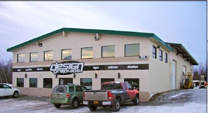
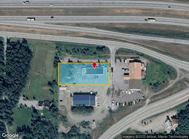
Property Record
1930 S Whiting Cir, Palmer, AK 99645
NEARBY LISTINGS FOR SALE OR LEASE
-
-
View all Palmer listings for sale on LoopNet.com
Property Detail
1930 S Whiting Cir
Anchorage, AK
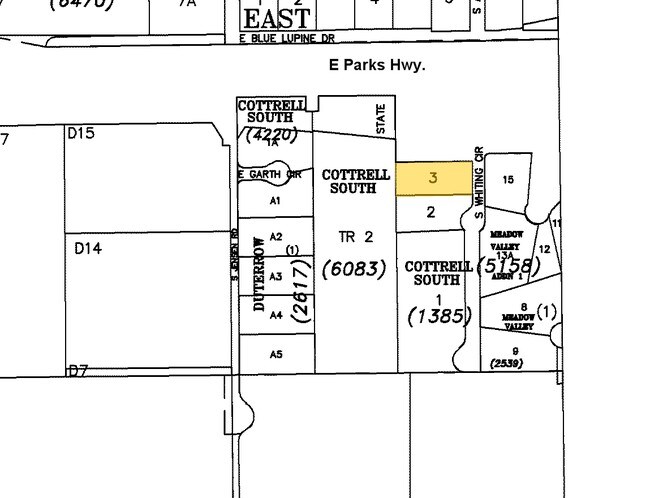
Cottrell S Rsb T/3 & 4
1385000L003
COTTRELL S RSB T/3 & 4 LOT 3
Commercialnec
Matanuska-Susitna
X
Alaska
02170C8120F
3
2024
0.92 AC
2025
Mat-Su Business Region
001100
Anchorage
DEMOGRAPHICS near 1930 S Whiting Cir
1 Mile
3 Mile
5 Mile
2024 Total Population
933
9,641
27,446
2029 Population
1,066
11,017
31,409
Pop Growth 2024-2029
+ 14.26%
+ 14.27%
+ 14.44%
Average Age
36
37
37
2024 Total Households
308
3,281
9,513
HH Growth 2024-2029
+ 14.61%
+ 14.87%
+ 15.01%
Median Household Inc
$112,500
$100,552
$92,681
Avg Household Size
3.10
2.90
2.80
2024 Avg HH Vehicles
3.00
3.00
2.00
Median Home Value
$367,977
$355,428
$327,060
Median Year Built
2002
1999
1999
Nearby Places
Map Layers
Map Styles
 Street
 Aerial
- Restaurants
- Banks
- Shops
- Fitness
- Groceries
PUBLIC TRANSPORTATION
AIRPORT
Merrill Field
DRIVE
WALK
Distance
Merrill Field
45 min
36.1 mi
Freight Ports
Port of Anchorage
DRIVE
WALK
Distance
Port of Anchorage
51 min
38.8 mi
Nearby Properties
Address
Land Use
TOTAL SIZE
Lot Size
Zoning
Address
Land Use
TOTAL SIZE
Lot Size
Zoning
23.23 AC
6
Address
Land Use
TOTAL SIZE
Lot Size
Zoning
1.08 AC
6
Address
Land Use
TOTAL SIZE
Lot Size
Zoning
174.31 AC
4
Address
Land Use
TOTAL SIZE
Lot Size
Zoning
1.02 AC
6
Address
Land Use
TOTAL SIZE
Lot Size
Zoning
51,000 SF
14.54 AC
8
Address
Land Use
TOTAL SIZE
Lot Size
Zoning
Address
Land Use
TOTAL SIZE
Lot Size
Zoning
26,646 SF
3.98 AC
6
Address
Land Use
TOTAL SIZE
Lot Size
Zoning
58,214 SF
5.16 AC
35
Address
Land Use
TOTAL SIZE
Lot Size
Zoning
30,042 SF
2.72 AC
6
Address
Land Use
TOTAL SIZE
Lot Size
Zoning
10.39 AC
6
Address
Land Use
TOTAL SIZE
Lot Size
Zoning
49,305 SF
5 AC
6
Address
Land Use
TOTAL SIZE
Lot Size
Zoning
2,636 SF
7.53 AC
17
Address
Land Use
TOTAL SIZE
Lot Size
Zoning
22,001 SF
4.95 AC
4
Address
Land Use
TOTAL SIZE
Lot Size
Zoning
28,574 SF
13.08 AC
7
Address
Land Use
TOTAL SIZE
Lot Size
Zoning
184.75 AC
4
Address
Land Use
TOTAL SIZE
Lot Size
Zoning
55.31 AC
4
Address
Land Use
TOTAL SIZE
Lot Size
Zoning
25,890 SF
16.24 AC
4
Address
Land Use
TOTAL SIZE
Lot Size
Zoning
59,201 SF
4.94 AC
17
Address
Land Use
TOTAL SIZE
Lot Size
Zoning
392 SF
12.15 AC
7
Address
Land Use
TOTAL SIZE
Lot Size
Zoning
4,800 SF
3.70 AC
6
Address
Land Use
TOTAL SIZE
Lot Size
Zoning
Address
Land Use
TOTAL SIZE
Lot Size
Zoning
11,588 SF
1.76 AC
6
Address
Land Use
TOTAL SIZE
Lot Size
Zoning
Address
Land Use
TOTAL SIZE
Lot Size
Zoning
5,092 SF
3.25 AC
6
Address
Land Use
TOTAL SIZE
Lot Size
Zoning
43,291 SF
8.48 AC
35
Address
Land Use
TOTAL SIZE
Lot Size
Zoning
1,422 SF
10.87 AC
6
Address
Land Use
TOTAL SIZE
Lot Size
Zoning
952 SF
2.47 AC
6
Address
Land Use
TOTAL SIZE
Lot Size
Zoning
Address
Land Use
TOTAL SIZE
Lot Size
Zoning
22,584 SF
1.10 AC
6
Address
Land Use
TOTAL SIZE
Lot Size
Zoning
7.72 AC
7
The World's #1 Commercial Real Estate Marketplace
Connect with us
© 2026 CoStar Group
The information above has been obtained from sources believed reliable. While we do not doubt its accuracy we have not verified it and make no guarantee, warranty or representation about it. It is your responsibility to independently confirm its accuracy and completeness. Any projections, opinions, assumptions, or estimates used are for example only and do not represent the current or future performance of the property. The value of this transaction to you depends on tax and other factors which should be evaluated by your tax, financial, and legal advisors. You and your advisors should conduct a careful, independent investigation of the property to determine to your satisfaction the suitability of the property for your needs.