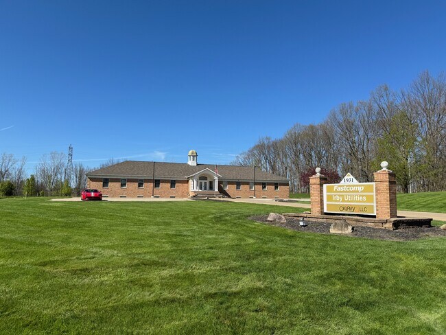
Property Record
1931 Georgetown Rd, Hudson, OH 44236


Property Detail
1931 Georgetown Rd
Akron, OH
HUDSON SOUTH COMMERCIAL PK BLK C E PT 230 FT FRT 3.26AC
30-07369
Summit
Officebuilding
Ohio
2023
3.26 AC
2025
Akron
533200
Cleveland
11,880 SF
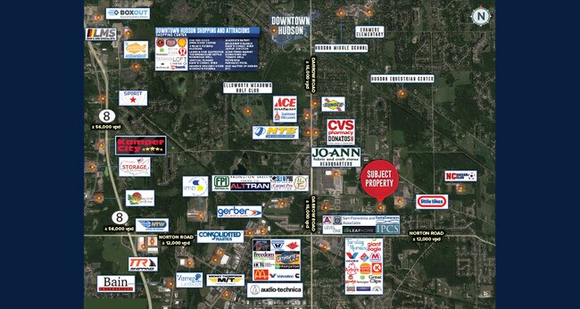
NEARBY LISTINGS FOR SALE OR LEASE
DEMOGRAPHICS near 1931 Georgetown Rd
1 mile
3 mile
5 mile
2025 Total Population
3,344
35,322
94,847
2030 Population
3,330
35,221
95,362
Pop Growth 2025-2030
(0.42%)
(0.29%)
+ 0.54%
Average Age
43
42
42
2025 Total Households
1,267
13,666
39,098
HH Growth 2025-2030
(0.47%)
(0.25%)
+ 0.67%
Median Household Inc
$130,303
$117,156
$100,220
Avg Household Size
2.50
2.50
2.40
2025 Avg HH Vehicles
2.00
2.00
2.00
Median Home Value
$323,753
$314,663
$295,079
Median Year Built
1990
1979
1978
Nearby Places
Map Layers
Map Styles
 Street
 Aerial
Layers
 Traffic
 Biking
Places
Listings with unknown addresses are not visible on the map
- Restaurants
- Banks
- Shops
- Fitness
- Groceries
PUBLIC TRANSPORTATION
COMMUTER RAIL
Drive
Walk
Distance
17 min
8.0 mi
Drive
Walk
Distance
20 min
9.8 mi
AIRPORT
Akron-Canton Regional
Drive
Walk
Distance
Akron-Canton Regional
39 min
24.9 mi
Cleveland-Hopkins International
Drive
Walk
Distance
Cleveland-Hopkins International
52 min
34.5 mi
SALE & LEASE HISTORY
LISTING DATE
SALE/LEASE

Sep 27, 2022
For Lease
Jun 16, 2022
For Lease
Jun 06, 2018
For Lease
Dec 30, 2022
For Sale
Aug 18, 2021
For Sale
Nearby Properties
Address
Land Use
TOTAL SIZE
Lot Size
Zoning
Address
Land Use
TOTAL SIZE
Lot Size
Zoning
201,734 SF
92.42 AC
Address
Land Use
TOTAL SIZE
Lot Size
Zoning
Address
Land Use
TOTAL SIZE
Lot Size
Zoning
Address
Land Use
TOTAL SIZE
Lot Size
Zoning
Address
Land Use
TOTAL SIZE
Lot Size
Zoning
114,568 SF
11.55 AC
Address
Land Use
TOTAL SIZE
Lot Size
Zoning
1,302,677 SF
121.15 AC
Address
Land Use
TOTAL SIZE
Lot Size
Zoning
15.41 AC
Address
Land Use
TOTAL SIZE
Lot Size
Zoning
145,844 SF
9.80 AC
Address
Land Use
TOTAL SIZE
Lot Size
Zoning
60,022 SF
3.63 AC
Address
Land Use
TOTAL SIZE
Lot Size
Zoning
Address
Land Use
TOTAL SIZE
Lot Size
Zoning
84,500 SF
8.14 AC
Address
Land Use
TOTAL SIZE
Lot Size
Zoning
625,640 SF
45.31 AC
Address
Land Use
TOTAL SIZE
Lot Size
Zoning
144,295 SF
17.27 AC
Address
Land Use
TOTAL SIZE
Lot Size
Zoning
17,731 SF
216.50 AC
Address
Land Use
TOTAL SIZE
Lot Size
Zoning
Address
Land Use
TOTAL SIZE
Lot Size
Zoning
157,827 SF
26.63 AC
Address
Land Use
TOTAL SIZE
Lot Size
Zoning
90,820 SF
23.72 AC
Address
Land Use
TOTAL SIZE
Lot Size
Zoning
Address
Land Use
TOTAL SIZE
Lot Size
Zoning
68,855 SF
32.57 AC
Address
Land Use
TOTAL SIZE
Lot Size
Zoning
170,929 SF
16.29 AC
Address
Land Use
TOTAL SIZE
Lot Size
Zoning
26,231 SF
14.40 AC
Address
Land Use
TOTAL SIZE
Lot Size
Zoning
21.80 AC
Address
Land Use
TOTAL SIZE
Lot Size
Zoning
12.94 AC
Address
Land Use
TOTAL SIZE
Lot Size
Zoning
Address
Land Use
TOTAL SIZE
Lot Size
Zoning
619,128 SF
19.95 AC
Address
Land Use
TOTAL SIZE
Lot Size
Zoning
23,720 SF
17.58 AC
Address
Land Use
TOTAL SIZE
Lot Size
Zoning
6.52 AC
Address
Land Use
TOTAL SIZE
Lot Size
Zoning
7.20 AC
Address
Land Use
TOTAL SIZE
Lot Size
Zoning
121,950 SF
9.19 AC
Address
Land Use
TOTAL SIZE
Lot Size
Zoning
47,584 SF
12.45 AC
The World's #1 Commercial Real Estate Marketplace
Connect with us
© 2026 CoStar Group
The information above has been obtained from sources believed reliable. While we do not doubt its accuracy we have not verified it and make no guarantee, warranty or representation about it. It is your responsibility to independently confirm its accuracy and completeness. Any projections, opinions, assumptions, or estimates used are for example only and do not represent the current or future performance of the property. The value of this transaction to you depends on tax and other factors which should be evaluated by your tax, financial, and legal advisors. You and your advisors should conduct a careful, independent investigation of the property to determine to your satisfaction the suitability of the property for your needs.