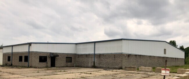
Property Record
1931 Industrial Park Rd, Sardis, MS 38666

NEARBY LISTINGS FOR SALE OR LEASE
-
-
View all Sardis listings for lease on LoopNet.com
Property Detail
1931 Industrial Park Rd
Officebuilding
10.6AC PT W1/2 SE1/4
X
Panola
28107C0195E
Mississippi
2024
10.60 AC
2024
Tupelo/North Area
950102
Other Market Areas
1,462 SF
1131-0200000-0001403
DEMOGRAPHICS near 1931 Industrial Park Rd
1 Mile
3 Mile
5 Mile
2024 Total Population
389
3,053
5,343
2029 Population
379
2,982
5,244
Pop Growth 2024-2029
(2.57%)
(2.33%)
(1.85%)
Average Age
38
40
40
2024 Total Households
143
1,193
2,079
HH Growth 2024-2029
(2.10%)
(2.26%)
(1.78%)
Median Household Inc
$20,208
$31,138
$32,704
Avg Household Size
2.60
2.50
2.50
2024 Avg HH Vehicles
2.00
2.00
2.00
Median Home Value
$69,999
$77,282
$87,515
Median Year Built
1972
1972
1978
Nearby Places
Map Layers
Map Styles
 Street
 Aerial
- Restaurants
- Banks
- Shops
- Fitness
- Groceries
SALE & LEASE HISTORY
LISTING DATE
SALE/LEASE

May 14, 2020
For Lease
May 05, 2020
For Sale
Nearby Properties
Address
Land Use
TOTAL SIZE
Lot Size
Zoning
Address
Land Use
TOTAL SIZE
Lot Size
Zoning
103,684 SF
21 AC
Address
Land Use
TOTAL SIZE
Lot Size
Zoning
17,100 SF
40 AC
Address
Land Use
TOTAL SIZE
Lot Size
Zoning
4,032 SF
6 AC
Address
Land Use
TOTAL SIZE
Lot Size
Zoning
7,224 SF
8.20 AC
Address
Land Use
TOTAL SIZE
Lot Size
Zoning
2,800 SF
1.20 AC
Address
Land Use
TOTAL SIZE
Lot Size
Zoning
5,790 SF
4 AC
Address
Land Use
TOTAL SIZE
Lot Size
Zoning
4,155 SF
5.70 AC
Address
Land Use
TOTAL SIZE
Lot Size
Zoning
15,250 SF
3.60 AC
Address
Land Use
TOTAL SIZE
Lot Size
Zoning
11,561 SF
2.80 AC
Address
Land Use
TOTAL SIZE
Lot Size
Zoning
2,572 SF
1.02 AC
Address
Land Use
TOTAL SIZE
Lot Size
Zoning
767,106 SF
5 AC
Address
Land Use
TOTAL SIZE
Lot Size
Zoning
634 SF
2.40 AC
Address
Land Use
TOTAL SIZE
Lot Size
Zoning
5,725 SF
1.80 AC
Address
Land Use
TOTAL SIZE
Lot Size
Zoning
10,690 SF
2.10 AC
Address
Land Use
TOTAL SIZE
Lot Size
Zoning
7,966 SF
0.35 AC
Address
Land Use
TOTAL SIZE
Lot Size
Zoning
5,457 SF
0.81 AC
Address
Land Use
TOTAL SIZE
Lot Size
Zoning
2,118 SF
14.60 AC
Address
Land Use
TOTAL SIZE
Lot Size
Zoning
10,381 SF
0.72 AC
Address
Land Use
TOTAL SIZE
Lot Size
Zoning
5,451 SF
4.20 AC
Address
Land Use
TOTAL SIZE
Lot Size
Zoning
21,861 SF
10 AC
Address
Land Use
TOTAL SIZE
Lot Size
Zoning
2,892 SF
1.40 AC
Address
Land Use
TOTAL SIZE
Lot Size
Zoning
6,048 SF
1.10 AC
Address
Land Use
TOTAL SIZE
Lot Size
Zoning
2,414 SF
0.54 AC
The World's #1 Commercial Real Estate Marketplace
Connect with us
© 2025 CoStar Group
The information above has been obtained from sources believed reliable. While we do not doubt its accuracy we have not verified it and make no guarantee, warranty or representation about it. It is your responsibility to independently confirm its accuracy and completeness. Any projections, opinions, assumptions, or estimates used are for example only and do not represent the current or future performance of the property. The value of this transaction to you depends on tax and other factors which should be evaluated by your tax, financial, and legal advisors. You and your advisors should conduct a careful, independent investigation of the property to determine to your satisfaction the suitability of the property for your needs.