Property Record
10460 Norris Ferry Rd, Shreveport, LA 71106


NEARBY LISTINGS FOR SALE OR LEASE
Property Detail
10460 Norris Ferry Rd
161320-000-0096-00
T 16 N, R 13 W
Commercialnec
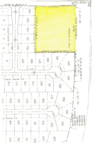
2.776 ACS. M/L - ALL THAT LYING S. & E. OF NORRIS FERRY LANDING SUBDIVISION, UNIT NO. 1 & N. OF EAST-WEST ROADWAY IN SE/4 OF
X
Caddo
22017C0605H
Louisiana
2024
2.78 AC
2024
Caddo Parish
024001
Shreveport/Bossier City
13,363 SF
Shreveport-Bossier City, LA
DEMOGRAPHICS near 10460 Norris Ferry Rd
1 Mile
3 Mile
5 Mile
2024 Total Population
4,272
12,003
33,218
2029 Population
4,010
11,208
31,415
Pop Growth 2024-2029
(6.13%)
(6.62%)
(5.43%)
Average Age
40
41
41
2024 Total Households
1,524
4,277
13,613
HH Growth 2024-2029
(6.23%)
(6.69%)
(5.45%)
Median Household Inc
$150,329
$138,499
$76,911
Avg Household Size
2.70
2.70
2.40
2024 Avg HH Vehicles
3.00
2.00
2.00
Median Home Value
$350,974
$325,426
$254,723
Median Year Built
2004
2000
1989
Nearby Places
Map Layers
Map Styles
 Street
 Aerial
- Restaurants
- Banks
- Shops
- Fitness
- Groceries
PUBLIC TRANSPORTATION
AIRPORT
Shreveport Regional
DRIVE
WALK
Distance
Shreveport Regional
17 min
15.5 mi
Nearby Properties
Address
Land Use
TOTAL SIZE
Lot Size
Zoning
Address
Land Use
TOTAL SIZE
Lot Size
Zoning
164,717 SF
19.56 AC
Address
Land Use
TOTAL SIZE
Lot Size
Zoning
128,786 SF
12.40 AC
Address
Land Use
TOTAL SIZE
Lot Size
Zoning
56,166 SF
6.89 AC
Address
Land Use
TOTAL SIZE
Lot Size
Zoning
40,255 SF
13.10 AC
Address
Land Use
TOTAL SIZE
Lot Size
Zoning
24,768 SF
3.54 AC
Address
Land Use
TOTAL SIZE
Lot Size
Zoning
32,420 SF
34.33 AC
Address
Land Use
TOTAL SIZE
Lot Size
Zoning
151,460 SF
42.82 AC
Address
Land Use
TOTAL SIZE
Lot Size
Zoning
24,817 SF
18.79 AC
Address
Land Use
TOTAL SIZE
Lot Size
Zoning
41,161 SF
124.97 AC
Address
Land Use
TOTAL SIZE
Lot Size
Zoning
11,412 SF
7.70 AC
Address
Land Use
TOTAL SIZE
Lot Size
Zoning
5,354 SF
1.67 AC
Address
Land Use
TOTAL SIZE
Lot Size
Zoning
65,280 SF
3.70 AC
Address
Land Use
TOTAL SIZE
Lot Size
Zoning
4,555 SF
1.04 AC
Address
Land Use
TOTAL SIZE
Lot Size
Zoning
7,820 SF
1.45 AC
Address
Land Use
TOTAL SIZE
Lot Size
Zoning
12,084 SF
2.37 AC
Address
Land Use
TOTAL SIZE
Lot Size
Zoning
12,615 SF
2 AC
Address
Land Use
TOTAL SIZE
Lot Size
Zoning
5,600 SF
0.20 AC
Address
Land Use
TOTAL SIZE
Lot Size
Zoning
17,060 SF
0.67 AC
Address
Land Use
TOTAL SIZE
Lot Size
Zoning
11,482 SF
0.17 AC
Address
Land Use
TOTAL SIZE
Lot Size
Zoning
5.52 AC
Address
Land Use
TOTAL SIZE
Lot Size
Zoning
4,500 SF
10.93 AC
Address
Land Use
TOTAL SIZE
Lot Size
Zoning
3,875 SF
1.53 AC
Address
Land Use
TOTAL SIZE
Lot Size
Zoning
3,552 SF
3 AC
Address
Land Use
TOTAL SIZE
Lot Size
Zoning
3,900 SF
1.50 AC
Address
Land Use
TOTAL SIZE
Lot Size
Zoning
198 SF
1.33 AC
Address
Land Use
TOTAL SIZE
Lot Size
Zoning
5,124 SF
0.28 AC
Address
Land Use
TOTAL SIZE
Lot Size
Zoning
28,500 SF
2.70 AC
Address
Land Use
TOTAL SIZE
Lot Size
Zoning
4,010 SF
0.77 AC
Address
Land Use
TOTAL SIZE
Lot Size
Zoning
3,854 SF
0.77 AC
The World's #1 Commercial Real Estate Marketplace
Connect with us
© 2025 CoStar Group
The information above has been obtained from sources believed reliable. While we do not doubt its accuracy we have not verified it and make no guarantee, warranty or representation about it. It is your responsibility to independently confirm its accuracy and completeness. Any projections, opinions, assumptions, or estimates used are for example only and do not represent the current or future performance of the property. The value of this transaction to you depends on tax and other factors which should be evaluated by your tax, financial, and legal advisors. You and your advisors should conduct a careful, independent investigation of the property to determine to your satisfaction the suitability of the property for your needs.