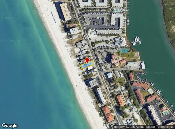
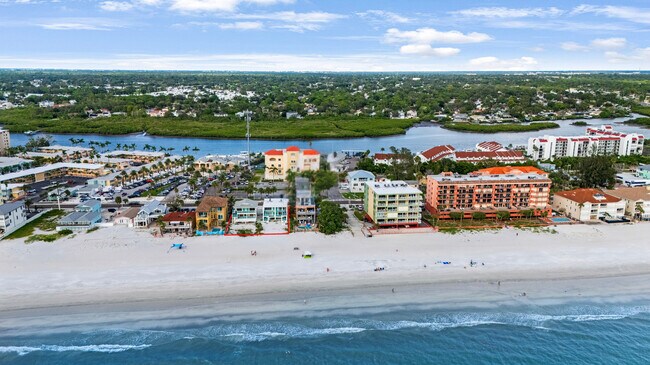
Property Record
19310 Gulf Blvd, Indian Shores, FL 33785
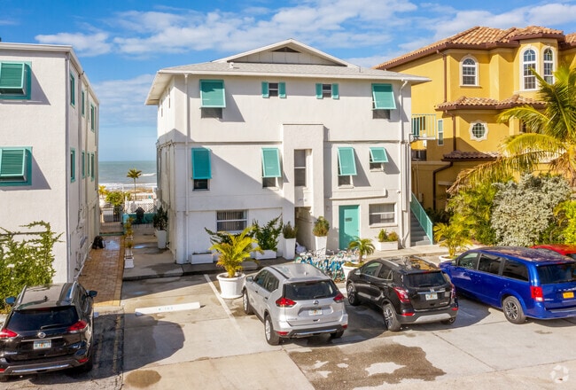
This Property Is For Sale
NEARBY LISTINGS FOR SALE OR LEASE
Property Detail
19310 Gulf Blvd
Tampa-St. Petersburg-Clearwater, FL
Indian Pass Beach Re-Rev
30-30-15-42804-001-0120
INDIAN PASS BEACH RE-REV BLK 1, LOT 12 W OF HIGHWAY
Hotel
Pinellas
VE
Florida
12103C0177H
12
2024
0.18 AC
2025
Indian Shores
027703
Tampa/St Petersburg
5,065 SF
DEMOGRAPHICS near 19310 Gulf Blvd
1 Mile
3 Mile
5 Mile
2024 Total Population
7,500
45,718
115,123
2029 Population
7,865
46,599
116,676
Pop Growth 2024-2029
+ 4.87%
+ 1.93%
+ 1.35%
Average Age
54
50
50
2024 Total Households
3,605
20,806
54,276
HH Growth 2024-2029
+ 5.38%
+ 2.23%
+ 1.48%
Median Household Inc
$93,307
$82,631
$70,402
Avg Household Size
2.00
2.10
2.10
2024 Avg HH Vehicles
2.00
2.00
2.00
Median Home Value
$453,999
$389,953
$338,392
Median Year Built
1978
1976
1975
Nearby Places
- Restaurants
- Banks
- Shops
- Fitness
- Groceries
PUBLIC TRANSPORTATION
AIRPORT
St Pete-Clearwater International
DRIVE
WALK
Distance
St Pete-Clearwater International
34 min
15.7 mi
Tampa International
DRIVE
WALK
Distance
Tampa International
44 min
26.7 mi
Freight Ports
Port Manatee
DRIVE
WALK
Distance
Port Manatee
58 min
37.3 mi
Nearby Properties
Address
Land Use
TOTAL SIZE
Lot Size
Zoning
Address
Land Use
TOTAL SIZE
Lot Size
Zoning
223,748 SF
100.32 AC
R3
Address
Land Use
TOTAL SIZE
Lot Size
Zoning
101,642 SF
1.43 AC
Address
Land Use
TOTAL SIZE
Lot Size
Zoning
267,730 SF
35.84 AC
AE
Address
Land Use
TOTAL SIZE
Lot Size
Zoning
6,098 SF
374.66 AC
AE
Address
Land Use
TOTAL SIZE
Lot Size
Zoning
5,647 SF
187.56 AC
AE
Address
Land Use
TOTAL SIZE
Lot Size
Zoning
236,240 SF
12.38 AC
RPD15
Address
Land Use
TOTAL SIZE
Lot Size
Zoning
222,888 SF
11.83 AC
RPD15
Address
Land Use
TOTAL SIZE
Lot Size
Zoning
133,440 SF
6.85 AC
RM15
Address
Land Use
TOTAL SIZE
Lot Size
Zoning
440 SF
3.47 AC
Address
Land Use
TOTAL SIZE
Lot Size
Zoning
102,073 SF
9.07 AC
Address
Land Use
TOTAL SIZE
Lot Size
Zoning
160,134 SF
18.61 AC
R2
Address
Land Use
TOTAL SIZE
Lot Size
Zoning
147,755 SF
6.86 AC
Address
Land Use
TOTAL SIZE
Lot Size
Zoning
110,192 SF
4.58 AC
Address
Land Use
TOTAL SIZE
Lot Size
Zoning
36,102 SF
2.32 AC
Address
Land Use
TOTAL SIZE
Lot Size
Zoning
90,234 SF
9.82 AC
R2
Address
Land Use
TOTAL SIZE
Lot Size
Zoning
80,296 SF
19.86 AC
R2
Address
Land Use
TOTAL SIZE
Lot Size
Zoning
83,103 SF
12.59 AC
AE
Address
Land Use
TOTAL SIZE
Lot Size
Zoning
56,655 SF
5.98 AC
R3
Address
Land Use
TOTAL SIZE
Lot Size
Zoning
9.55 AC
Address
Land Use
TOTAL SIZE
Lot Size
Zoning
74,305 SF
3.06 AC
C2
Address
Land Use
TOTAL SIZE
Lot Size
Zoning
82,796 SF
19.23 AC
R2
Address
Land Use
TOTAL SIZE
Lot Size
Zoning
41,407 SF
6.75 AC
R2
Address
Land Use
TOTAL SIZE
Lot Size
Zoning
60,456 SF
8.45 AC
Address
Land Use
TOTAL SIZE
Lot Size
Zoning
4,955 SF
9.69 AC
C2
Address
Land Use
TOTAL SIZE
Lot Size
Zoning
104,800 SF
4.81 AC
C3
Address
Land Use
TOTAL SIZE
Lot Size
Zoning
72,986 SF
7.98 AC
C2
Address
Land Use
TOTAL SIZE
Lot Size
Zoning
55,323 SF
23.89 AC
AE
Address
Land Use
TOTAL SIZE
Lot Size
Zoning
52,880 SF
6.01 AC
C2
Address
Land Use
TOTAL SIZE
Lot Size
Zoning
79,991 SF
9.42 AC
AE
Address
Land Use
TOTAL SIZE
Lot Size
Zoning
78,866 SF
6.65 AC
The World's #1 Commercial Real Estate Marketplace
Connect with us
© 2025 CoStar Group
The information above has been obtained from sources believed reliable. While we do not doubt its accuracy we have not verified it and make no guarantee, warranty or representation about it. It is your responsibility to independently confirm its accuracy and completeness. Any projections, opinions, assumptions, or estimates used are for example only and do not represent the current or future performance of the property. The value of this transaction to you depends on tax and other factors which should be evaluated by your tax, financial, and legal advisors. You and your advisors should conduct a careful, independent investigation of the property to determine to your satisfaction the suitability of the property for your needs.