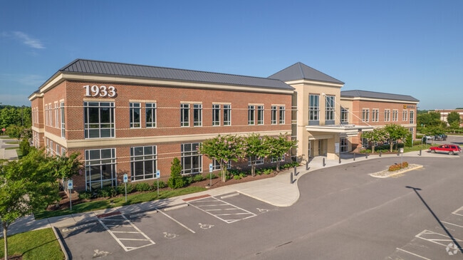
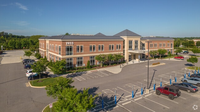
Property Record
1933 Edwin Dr, Chesapeake, VA 23322

Current Lease Availabilities
Property Detail
1933 Edwin Dr
0730000001860
PAR 10B SUB PAR 10 EDINBURGH COMMONS WEST 12.000AC
Medicalbuilding
Chesapeake City
PUD: PLANN
Virginia
B and X Area of moderate flood hazard, usually the area between the limits of the 100-year and 500-year floods.
12 AC
2024
Southern Chesapeake
2025
Hampton Roads
021004
Virginia Beach-Chesapeake-Norfolk, VA-NC
59,374 SF
NEARBY LISTINGS FOR SALE OR LEASE
DEMOGRAPHICS near 1933 Edwin Dr
1 mile
3 mile
5 mile
2025 Total Population
3,324
16,842
54,575
2030 Population
3,445
17,216
55,353
Pop Growth 2025-2030
+ 3.64%
+ 2.22%
+ 1.43%
Average Age
37
40
40
2025 Total Households
1,096
5,603
18,079
HH Growth 2025-2030
+ 3.74%
+ 2.32%
+ 1.52%
Median Household Inc
$161,260
$155,838
$137,563
Avg Household Size
3.00
3.00
2.90
2025 Avg HH Vehicles
2.00
3.00
2.00
Median Home Value
$697,324
$534,320
$468,484
Median Year Built
2010
1996
1990
Nearby Places
Map Layers
Map Styles
 Street
 Aerial
Transit
 Traffic
 Biking
Places
Listings with unknown addresses are not visible on the map
- Restaurants
- Banks
- Shops
- Fitness
- Groceries
PUBLIC TRANSPORTATION
AIRPORT
Norfolk International
Drive
Walk
Distance
Norfolk International
34 min
20.9 mi
Nearby Properties
Address
Land Use
TOTAL SIZE
Lot Size
Zoning
Address
Land Use
TOTAL SIZE
Lot Size
Zoning
295,711 SF
186.95 AC
MULTI: MUL
Address
Land Use
TOTAL SIZE
Lot Size
Zoning
219,005 SF
15.64 AC
PUD: PLANN
Address
Land Use
TOTAL SIZE
Lot Size
Zoning
7,682 SF
11.74 AC
PUD: PLANN
Address
Land Use
TOTAL SIZE
Lot Size
Zoning
264,336 SF
73.49 AC
A1: AGRICU
Address
Land Use
TOTAL SIZE
Lot Size
Zoning
99,662 SF
15.68 AC
B2: GENERA
Address
Land Use
TOTAL SIZE
Lot Size
Zoning
153,854 SF
20.35 AC
PUD: PLANN
Address
Land Use
TOTAL SIZE
Lot Size
Zoning
81,443 SF
5.87 AC
PUD: PLANN
Address
Land Use
TOTAL SIZE
Lot Size
Zoning
125,594 SF
11.80 AC
PUD: PLANN
Address
Land Use
TOTAL SIZE
Lot Size
Zoning
2,576 SF
101.54 AC
PUD: PLANN
Address
Land Use
TOTAL SIZE
Lot Size
Zoning
15,530 SF
11.99 AC
B2: GENERA
Address
Land Use
TOTAL SIZE
Lot Size
Zoning
110,805 SF
12.20 AC
PUD: PLANN
Address
Land Use
TOTAL SIZE
Lot Size
Zoning
46,615 SF
6.30 AC
B2: GENERA
Address
Land Use
TOTAL SIZE
Lot Size
Zoning
110 SF
3 AC
M1: LIGHT
Address
Land Use
TOTAL SIZE
Lot Size
Zoning
47,779 SF
5.85 AC
PUD: PLANN
Address
Land Use
TOTAL SIZE
Lot Size
Zoning
30,734 SF
4.93 AC
PUD: PLANN
Address
Land Use
TOTAL SIZE
Lot Size
Zoning
79,054 SF
17.61 AC
R15S: RESI
Address
Land Use
TOTAL SIZE
Lot Size
Zoning
48.50 AC
R8S: RESID
Address
Land Use
TOTAL SIZE
Lot Size
Zoning
26,139 SF
2.84 AC
PUD: PLANN
Address
Land Use
TOTAL SIZE
Lot Size
Zoning
16,130 SF
11.94 AC
AC: ASSEMB
Address
Land Use
TOTAL SIZE
Lot Size
Zoning
61.03 AC
PUD: PLANN
Address
Land Use
TOTAL SIZE
Lot Size
Zoning
20,468 SF
7.09 AC
B2: GENERA
Address
Land Use
TOTAL SIZE
Lot Size
Zoning
14,736 SF
2.27 AC
B2: GENERA
Address
Land Use
TOTAL SIZE
Lot Size
Zoning
5,698 SF
2.26 AC
PUD: PLANN
Address
Land Use
TOTAL SIZE
Lot Size
Zoning
71,430 SF
12.16 AC
R15S: RESI
Address
Land Use
TOTAL SIZE
Lot Size
Zoning
100,576 SF
40.64 AC
M1: LIGHT
Address
Land Use
TOTAL SIZE
Lot Size
Zoning
23.85 AC
PUD: PLANN
Address
Land Use
TOTAL SIZE
Lot Size
Zoning
13,036 SF
1.60 AC
O-I: OFFIC
Address
Land Use
TOTAL SIZE
Lot Size
Zoning
31.21 AC
RMF1: MULT
Address
Land Use
TOTAL SIZE
Lot Size
Zoning
22,402 SF
14.49 AC
A1: AGRICU
The World's #1 Commercial Real Estate Marketplace
Connect with us
© 2026 CoStar Group
The information above has been obtained from sources believed reliable. While we do not doubt its accuracy we have not verified it and make no guarantee, warranty or representation about it. It is your responsibility to independently confirm its accuracy and completeness. Any projections, opinions, assumptions, or estimates used are for example only and do not represent the current or future performance of the property. The value of this transaction to you depends on tax and other factors which should be evaluated by your tax, financial, and legal advisors. You and your advisors should conduct a careful, independent investigation of the property to determine to your satisfaction the suitability of the property for your needs.